Commons:Graphic Lab/Map workshop/Archive/2013
Federal states, including South Sudan[edit]
-
 A map displaying today's Unitary states and federations.

Request: Please add the South Sudan border and keep as green (see the basic image which includes the border: File:BlankMap-World6.svg . --Hazhk (talk) 00:21, 13 February 2013 (UTC)
Graphist opinion(s):
![]() Done--maxxl2
Done--maxxl2 ![]() - talk 22:54, 26 February 2013 (UTC)
- talk 22:54, 26 February 2013 (UTC)
- This section was archived on a request by: maxxl2
 - talk 22:54, 26 February 2013 (UTC)
LGBT rights in the world[edit]
-
 Current map

Article(s): Major map. Widely used in various Wikipedia projects, including Wikipedia's in pretty much every language.
Request:
- 0) Also made this request at English Wiki [1]
- 1) Make the map more in line with a reliable source: [2]
- 2) Add '"Propaganda law” restricting freedom of expression and association' (i.e., colour Russia)
- 3) Keep legal column colours as they are.
4) Change illeagal column colors: remove colour green (colour blind people confuse this colour [3]); merge "Up to life in prison" and "Heavy penalty"; and come up with a new colour scheme. The suggested scheme for illegal column:
|
Laws restricting freedom of expression and association
Imprisonment without precise indication of the length / unclear / other
Imprisonment up to 14 years
Imprisonment from 14 years to a life-long sentence
Up to death (ring = local judges)
|
:Cavann (talk) 00:23, 27 May 2013 (UTC) Withdrawn; editing svg maps was much easier than I thought Cavann (talk) 01:19, 4 July 2013 (UTC)
Graphist opinion(s):
- This section was archived on a request by: Cavann (talk) 01:19, 4 July 2013 (UTC)
New country of South Sudan NOT shown in map below[edit]
-
 Political map of Africa
 -
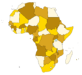


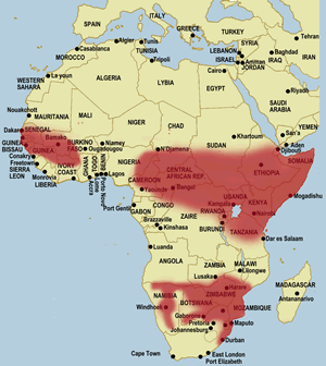
Request: Can this other political map of Africa--which is also heavily used on wikipedia--be updated with the borders of the new 2011 country of South Sudan? Right now it shows both Arab North Sudan and African South Sudan--which is not correct for 2012/2013. Perhaps South Sudan could be coloured white--or blue--if you wish to show that its a new state since July 2011. South Sudan is a member of the UN but this map shows a united North and South Sudan and is wrong today. Regards, --Leoboudv (talk) 05:52, 6 January 2013 (UTC)
Graphist opinion(s): Like this ? it's not svg, and it's rather raw. I don't consider learning svg to be a high priority, last thing I learn was 3D rendered animation, next thing is some programming languages. Someone else can vectorise this map, but I hope that the new map helps in the meantime. Penyulap ☏ 12:43, 7 January 2013 (UTC)
 Comment: Yes. The new map is fine. Thank You very much for your help Penyulap. Best Regards, --Leoboudv (talk) 19:31, 7 January 2013 (UTC)
- This section was archived on a request by: Patrick87 (talk) 11:13, 15 July 2013 (UTC)
Islamic Conquests[edit]
-
 Original map of the first 3 Islamic Caliphate conquests.
 -
 Abbasid Caliphate at its most extant
 -
 Suljuk Sultanate
 -
 Ottoman empire at its greatest extant


Request: Can you please add to the 1st map the Islands of the 2nd (Sicily and Sardinia) as well as Anatolia from the 3rd, and finally the Balkans and Crete and the other parts of eastern europe from the 4th, with color variation just like in the orginal map (maybe black for the Abbasids and red for the ottomans). Please Note: the areas to be added from the 2nd and 3rd maps should be in the same color since they both occurred during the Abbasid era and done by the name of the Abbasid caliph--باسم (talk) 21:34, 21 February 2013 (UTC)
Graphist opinion(s):

I'd like information not historical but rather graphical. If you can describe the parts and colours, I've made a sketch with extra parts and colours to assist. Penyulap ☏ 04:54, 26 February 2013 (UTC)
- Sure:
- Dark Red = Arabia, Prophet Muhammad Conquests.
- Light Red = Egypt and Libya and the Levant and Iraq and Iran and eastern Anatolia and beyond, Rashidun Conquests.
- Orange = Al-Maghrib, and Iberia, and Central Asia, Ummayid Conquests.
- Green = Western Anatolia, Mediterranean Islands , Abbasid Conquests (Note that North West Anatolia here in pink - byzantine lands, and the empire of trebizon should be black, since they are considered historically as ottoman conquests.
- Black: Eastern Europe (Just like the map you added, no other additions) = Ottoman conquests.
Hope this sums everything up--باسم (talk) 22:11, 26 February 2013 (UTC)
- like this ? Penyulap ☏ 01:13, 27 February 2013 (UTC)
- The parts in Circles should be black, the rest of Anatolia green. look here--باسم (talk) 21:19, 27 February 2013 (UTC)
- How about now ? Penyulap ☏ 23:51, 27 February 2013 (UTC)
- Yes, this is it :) Thanks!--باسم (talk) 16:16, 28 February 2013 (UTC)
- How about now ? Penyulap ☏ 23:51, 27 February 2013 (UTC)
- The parts in Circles should be black, the rest of Anatolia green. look here--باسم (talk) 21:19, 27 February 2013 (UTC)
- like this ? Penyulap ☏ 01:13, 27 February 2013 (UTC)
- This section was archived on a request by: Patrick87 (talk) 11:13, 15 July 2013 (UTC)
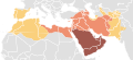
Upgrade 3 Maps: Remove Southern Sudan[edit]
-
 Silliwet block black map of the Arab World Including Southern Sudan
 -
 Arab World Including Southern Sudan
 -
new image


Request:
- These Maps still include southern Sudan as part of the Arab World although its been independent for almost 2 years now. Can you please crop it out of these maps. Thank you-- باسم (talk) 11:12, 12 May 2013 (UTC)
Graphist opinion(s):
-
there is a map here from another request which may be of use as a guide
-
 another image which might be helpful as a guide
.svg)
Penyulap ☏ 18:51, 15 May 2013 (UTC)
- here is one map, is it ok ? Penyulap ☏ 08:21, 22 May 2013 (UTC)
- Yeah these boarders need to be cut off--باسم (talk) 06:28, 23 May 2013 (UTC)
- I upload over the second one, I did not find good borders to use, it is approximate only. I hope this helps for now. Is it ok ? Penyulap ☏ 14:21, 19 June 2013 (UTC)
- Yes it is, Thanks alot :-)--باسم (talk) 07:26, 20 June 2013 (UTC)
- You're welcome باسم :) Penyulap ☏ 07:41, 20 June 2013 (UTC)
- Yes it is, Thanks alot :-)--باسم (talk) 07:26, 20 June 2013 (UTC)
- I upload over the second one, I did not find good borders to use, it is approximate only. I hope this helps for now. Is it ok ? Penyulap ☏ 14:21, 19 June 2013 (UTC)
- This section was archived on a request by: Patrick87 (talk) 11:13, 15 July 2013 (UTC)
Amelia Earhart flight route[edit]
-
 Start with something like this, then add lines for her route?
 -
 Or it might be better to start with a map centered on her missed leg?


Article(s): Amelia Earhart
Request:
- I would like to make a map of Amelia Earhart's flight plan to circumnavigate the world in 1937. I have it in table form in my sandbox, and was hoping there was an interactive map template where the points or lines could be created with latitude/longitude coordinates. Does such a template exist, or will I simply have to "eyeball" my lines on a world map? 74.4.31.253 13:12, 20 June 2013 (UTC)
Graphist opinion(s):
- This section was archived on a request by: Hellerick (talk) 02:45, 15 July 2013 (UTC)
Volta River[edit]
-
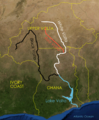 River Volta, showing Red, Black and White voltas
 -
 Penyulap's arabic version


Article(s): ar:نهر فولتا
Request:
- Blank map or Arabic version, in case of Arabic the names would be as follows:
- Upper Volta: الفولتا الأعلى
- Black Volta: الفولتا الأسود
- Red Volta: الفولتا الأحمر
- White Volta: الفولتا الأبيض
- Ivory Coast: ساحل العاج
- Ghana: غانا
- Lake Volta: بحيرة فولتا
- Atlantic Ocean: المحيط الأطلسي
Thank you --باسم (talk) 20:07, 26 June 2013 (UTC)
Graphist opinion(s): Like this ? if it is ok, can you fill out the filepage for me please.? Penyulap ☏ 21:11, 26 June 2013 (UTC)
- Yes this is it, thank you :-)--باسم (talk) 05:49, 27 June 2013 (UTC)
- This section was archived on a request by: Patrick87 (talk) 11:13, 15 July 2013 (UTC)
Map of Chinatown, Singapore[edit]

Request:
- Please crop. Thanks. — SMUconlaw (talk) 23:44, 17 July 2013 (UTC)
Graphist opinion(s):
 Done --Patrick87 (talk) 00:03, 18 July 2013 (UTC)
- Thanks for attending to this so quickly! — SMUconlaw (talk) 00:09, 18 July 2013 (UTC)
- This section was archived on a request by: Patrick87 (talk) 08:28, 18 July 2013 (UTC)
Map updating[edit]
- This section was archived on a request by: Aftab1995 (talk) 16:22, 24 December 2013 (UTC)
Request:
- Hello, can anyone please update those maps →File:BD Map admin.svg (just add Divisional Boundary for Rangpur Division & one ◙ for Rangpur District, Divisional Headquarter [under the Rangpur]), →File:Bangladesh physical map.svg (just add Divisional Boundary for Rangpur Division). This File:Bangladesh location map.svg map & this map will help you.
This is very very important coz this two maps use in many wikis. --Aftab1995 (talk) 19:06, 20 July 2013 (UTC)- Done by Wereldburger758 --Aftab1995 (talk) 16:22, 24 December 2013 (UTC)
- Hello, can anyone please update those maps →File:BD Map admin.svg (just add Divisional Boundary for Rangpur Division & one ◙ for Rangpur District, Divisional Headquarter [under the Rangpur]), →File:Bangladesh physical map.svg (just add Divisional Boundary for Rangpur Division). This File:Bangladesh location map.svg map & this map will help you.
Graphist opinion(s):
-
 This SVG file...
 -
 ...is replacing this.


Article(s): en:International Civil Aviation Organization airport code
Request:
- Just did the vector image above, and wonder whether the colours are suitable (e.g. to colour-blind users). I used six colours to separate the regions.
- I'm tempted to request it on the English wiki, but since the file is on Commons, I'll try here first. --Hytar (talk) 16:56, 27 July 2013 (UTC)
Graphist opinion(s):
- Color blind people have different problems so it's really hard to tell. I think I would have done it in different gray shades and with more visible borders. --Goran tek-en (talk) 21:54, 21 December 2013 (UTC)
- I agree that the colours are washed out, as I was concerned that darker shades might make identifying the text harder.
- After referring to colorbrewer2.org, I have found some other sets of base colours. I could go with A1 B1 C1 D1 E1 F1 , or your suggestion of A2 B2 C2 D2 E2 F2 . What do you think? Hytar (talk) 11:27, 3 January 2014 (UTC)
- I would go with the grayscale if your main concern was regarding color blinds ability to see it as intended. Done --Goran tek-en (talk) 12:19, 3 January 2014 (UTC)
- I would go with the grayscale if your main concern was regarding color blinds ability to see it as intended.
- This section was archived on a request by: Goran tek-en (talk) 12:23, 3 January 2014 (UTC)
Annexations of Riverside, California[edit]
-
 Riverside City Limit map, which shows upcoming annexations.

Request: This map (used here is not currently any more as you can see if you compare it with this. For example, part 107 in the map is already annexed to Riverside. I hope somebody can update it! Thanks! --Tgo9176 (talk) 11:21, 16 March 2013 (UTC)
Graphist opinion(s):
![]() Request taken by Goran tek-en (talk)
Request taken by Goran tek-en (talk)
I will make it into an svg which will make any changes in the future much easier. --Goran tek-en (talk) 16:56, 20 December 2013 (UTC)
- Have a look at this one here and give me feedback. --Goran tek-en (talk) 21:54, 22 December 2013 (UTC)
![]() Done You can find it here Annexr svg --Goran tek-en (talk)
Done You can find it here Annexr svg --Goran tek-en (talk)
- This section was archived on a request by: Goran tek-en (talk) 17:20, 10 January 2014 (UTC)
Montana Indian Reservations[edit]
-
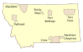 Montana Indian Reservations

Request: This has a misspelling on the map. "Rocky's Boys" should be "Rocky Boys". I tried to fix it but my software doesn't like SVG files.PumpkinSky talk 19:11, 24 March 2013 (UTC)
Graphist opinion(s):
- Done. 28bytes (talk) 19:28, 24 March 2013 (UTC)
- This section was archived on a request by: Goran tek-en (talk) 17:19, 10 January 2014 (UTC)
Updating municipality map of the Netherlands.[edit]
-
 2009 SVG of gemeenten in the Netherlands
 -
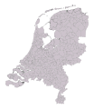 Success!


Request: I've been trying to update this map. I have found this GML file that has the gemeentegrenzen (published under CC-zero) that has the boundries as of 2012. Can anybody convert this into a SVG file where the id's have the kad:Code included? thanks. --Vera (talk) 13:57, 29 March 2013 (UTC)
Please?--Vera (talk) 11:42, 6 September 2013 (UTC)
Graphist opinion(s):
I have uploaded a SVG file here which I have created with QGIS. But I don't know any way to put data like ID's from the GIS file into the SVG file. --Alexrk2 (talk) 15:26, 6 September 2013 (UTC)
- I guess I need to go look for another GML file. This one doesn't have the borders between Flevoland and the Ijselmeer right. --Vera (talk) 15:40, 13 September 2013 (UTC)
- I found a Shapefile of the Dutch municipalities from 2012 here (you need gem_2012_v1) . It has the same license as the above mentioned file. I managed to load it in ArcGIS explorer but it doesn't draw anny border lines between the municipalities. Here the GM_CODE variable would be nice to have in the SVG file. Thanks for helping me out --Vera (talk) 21:19, 16 September 2013 (UTC)
- A friend of mine generated the SVG using the shapefile linked above. Yesterday I figured out that the order in which the SVG-path's were generated in this SVG is the same order in which the municipalities were listed under their CBS-number back in 2012 :). --Vera (talk) 13:56, 13 October 2013 (UTC)
- This section was archived on a request by: Goran tek-en (talk) 17:19, 10 January 2014 (UTC)
Bitmap in File:Volcanic_eruption_map.svg not showing[edit]

Request: I'm unsure where to post this so please move it to the appropriate place if needed.
Since the 4th version of this file, the embedded background bitmap has stopped showing in PNG rendered by Mediawiki. I can't see where it has gone wrong from the diffs, especially since it still shows when rendered directly by my browser (Firefox 20). Can someone please help? Thanks! --cmglee (talk) 18:56, 9 April 2013 (UTC)
Graphist opinion(s):
![]() Done: Fixed bitmap MIME type from image/jpg to image/jpeg.
Done: Fixed bitmap MIME type from image/jpg to image/jpeg.
- This section was archived on a request by: Goran tek-en (talk) 17:17, 10 January 2014 (UTC)
Mapping error in svg file[edit]
-
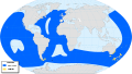 Map of Puffinus griseus distribution

Request:
- Please remove yellow dots in Caribbean area, the species does not nest there. Thanks! - MPF (talk) 14:59, 21 April 2013 (UTC)
Graphist opinion(s):
- Done - Dewclouds (talk) 23:08, 22 April 2013 (UTC)
- This section was archived on a request by: Goran tek-en (talk) 17:17, 10 January 2014 (UTC)
Please remove text from map[edit]

Article(s): [[]]
Request:
- A blank version of this map is requested, so that other languages can be added to it. Penyulap ☏ 16:27, 28 April 2013 (UTC)
Graphist opinion(s):
- Every user with basic SVG skills is able to edit a local version like the 8 other versions which are already available. The Arabic version can be prepared with a common text editor. I would have offered my help but unfortunately I'm not capable to type Arabic letters. --maxxl2 - talk 16:51, 28 April 2013 (UTC)
- I couldn't translate this map without ruining it, i can provide the Arabic text but i need a blank version. Thanks--باسم (talk) 20:46, 28 April 2013 (UTC)
- This section was archived on a request by: Goran tek-en (talk) 17:16, 10 January 2014 (UTC)
What is wrong?[edit]
I have just created and uploaded to commons the map below, and I can see two black rectangles over the map; once we see the full size map those rectangles disapear... Also, even in full size map some fonts are not as in original map I have created: DejaVu Sans Condensed and DejaVu Serif Condensed, that —once the map has been uploaded—, appear changed in other different font...
So, I have uploaded a map whose preview appears with two black rectangles over it; and whose fonts are not the same as those of my original map.
Any solution? Thank you

- I don't know why it happens (well, it seems mediawiki can't deal with some fonts), but I know how to deal with it. You should duplicate every text-containing layer (make their "export copies"), hide the original layers, and then convert "object to path" for each of these layers. Since no visible layer contains any text anymore, this bug won't show up. Here is a corrected version of the file. Hellerick (talk) 18:03, 29 May 2013 (UTC)
- Now it's ok. There were empy texts on the map: to find empty ‘Flowed text’ objects: 1) Edit - Deselect. 2) activate the text tool. 3) use TAB to cycle through all text objects in the drawing and watch the status line for the message “Type or edit flowed text (0 characters); Enter to start new paragraph”. 4) use DEL or Backspace to delete the selected empty ‘Flowed Text’ object. 5) continue with until the first text object is selected again. -- Yiyi (talk) 15:41, 30 May 2013 (UTC)
- The fonts still look ugly. Compare yours with mine Hellerick (talk) 03:43, 31 May 2013 (UTC)
- Now it's ok. There were empy texts on the map: to find empty ‘Flowed text’ objects: 1) Edit - Deselect. 2) activate the text tool. 3) use TAB to cycle through all text objects in the drawing and watch the status line for the message “Type or edit flowed text (0 characters); Enter to start new paragraph”. 4) use DEL or Backspace to delete the selected empty ‘Flowed Text’ object. 5) continue with until the first text object is selected again. -- Yiyi (talk) 15:41, 30 May 2013 (UTC)
- mmm no, I see my work exactly like your. But look at this link my work: [4]: it looks good... -- Yiyi (talk) 13:51, 31 May 2013 (UTC)
- This section was archived on a request by: Goran tek-en (talk) 17:15, 10 January 2014 (UTC)
West and East Malaysia[edit]
-
 West Malaysia
(Peninsular Malaysia) -
 East Malaysia
(Malaysian Borneo) -
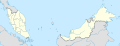 Map of Malaysia. Base map that could be used in making two separate maps
 -
 Kalimantan, Indonesia


Article(s): For Peninsular Malaysia, East Malaysia and other Malaysia-related articles that needs a map
Request:
- Since Malaysia is separated in two by the vast South China Sea, I'll make a request to have two separate maps to be created: for West (1st image) and East (2nd image). Currently there is a combined map of Malaysia (3rd image), I myself can separate it (but not deleting the original) however I'm not that much confident to do so since it needs geographical limits to have it done. Example is the 4th image which had been made (above Kalimantan is Brunei and Malaysian Borneo). Thanks! -- Adkranz (talk) 01:51, 1 June 2013 (UTC)
Graphist opinion(s):
- Here:


- Hellerick (talk) 09:40, 3 June 2013 (UTC)
- Good job! But one more thing Hellerick, the filenames were interchanged (East became West and vice-versa, see example above for reference). That's all and the rest is great :) Adkranz (talk) 23:03, 3 June 2013 (UTC)
- Oops, my bad. Fixed. Hellerick (talk) 08:28, 4 June 2013 (UTC)
- Good job! But one more thing Hellerick, the filenames were interchanged (East became West and vice-versa, see example above for reference). That's all and the rest is great :) Adkranz (talk) 23:03, 3 June 2013 (UTC)
- This section was archived on a request by: Goran tek-en (talk) 17:13, 10 January 2014 (UTC)
Blank Philippine Provinces map[edit]
-
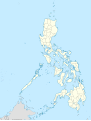 Philippines map
 -

-


Article(s):Articles on Philippine provinces
Request:
- Can someone make a version of the first map where each province can be recolored easily like the second map where each country can be recolored easily. I included a third map for reference, which is a svg map of the provinces of the Philipines, but the problem is the islands are not connected through groups (the provinces are connected through shapes, the thick white borders hide these) and if you remove the border of the provinces, gaps between provinces are revealed. Follow the borders of the first map--Hariboneagle927 (talk) 07:18, 3 October 2013 (UTC)
Graphist opinion(s):
- Done.
- The provincial division of the Philippines is quite complicated, please tell me if I made any mistake. Hellerick (talk) 07:23, 9 October 2013 (UTC)
- Thanks, there were some minor mistakes like sulu and tawi-tawi provinces were grouped as one province. Same case for Cagayan and Batanes provinces. I fixed these errors myself. Making the map colorable was my problem which was solved.--Hariboneagle927 (talk) 11:01, 14 October 2013 (UTC)
![]() Done
Done
- This section was archived on a request by: Goran tek-en (talk) 17:10, 10 January 2014 (UTC)
Assembly map of Delhi[edit]
Article(s): Some 100+ articles, e.g. Delhi, New Delhi, Chandni Chowk, Krishna Nagar, Janak Puri, Dwarka, etc.
Request:
- An SVG map of Delhi showing its assembly constituencies, similar to [5]. Thanks and regards.—Bill william comptonTalk 18:32, 22 October 2013 (UTC)
Graphist opinion(s):
- To me your request is not specific enough. I can do graphic work but I have to have all the information on hand. You link to some articles but do you want me to search for the information you want in those or what. It would be a great help if you could specify exactly what areas you want and if you can find a basic Delhi map to use as start. We can do graphic work but not search for all kind of information we know nothing about, please understand. --Goran tek-en (talk) 20:21, 5 December 2013 (UTC)
- Thanks for replying. I'm requesting an svg replica of the map available at this site or this one. I've created some, which you can find in Category:Election maps of Delhi and its sub-category. The map should depict Delhi and its 70 assembly constituencies (Hindi: Vidhan Sabha) and it would be much better if they are numbered, like here. Category:Maps of Delhi has some maps of Delhi which you can use. Or, you can directly trace the maps (from the aforementioned websites). I can do all this but I'm still learning to work with Inkscape. I would appreciate if you could give me some advice where to start learning or suggest a better tool.—Bill william comptonTalk 04:00, 13 December 2013 (UTC)
- You can have a check at a suggestion here. Give me feedback on it.
- I used this map as a base and then I imported and used this file for the numbers. I did clean up some in the original svg file manyally on junctions so they would met more correctly. I think Inkscape is very well suitet for this kind of work but you have to do it manually. The original svg file also had some white nearly following the borders which for me gave a disturbing look so I removed that as well. I think that a map or illustration should be as simple and clean as possible. Anything you add should be there for a reason, not just because you can do something fancy.
- So please have a look at my suggestion and give feedback. Also think of what name you want and which categoryes should be added for it when its finished. --Goran tek-en (talk) 13:48, 16 December 2013 (UTC)
- The constituency 38 is not numbered, it's in between 36 and 39; other than that, it looks very good. Thanks. You can name it "Vidhan Sabha constituencies of Delhi.svg" and add it to Category:Assembly constituencies of Delhi. I didn't add any white around the borders, at least not intentionally. I'm very naive to all this and only picked the tool because nobody had answered the request.—Bill william comptonTalk 04:47, 17 December 2013 (UTC)
- You can have a check at a suggestion here. Give me feedback on it.
- Thanks for replying. I'm requesting an svg replica of the map available at this site or this one. I've created some, which you can find in Category:Election maps of Delhi and its sub-category. The map should depict Delhi and its 70 assembly constituencies (Hindi: Vidhan Sabha) and it would be much better if they are numbered, like here. Category:Maps of Delhi has some maps of Delhi which you can use. Or, you can directly trace the maps (from the aforementioned websites). I can do all this but I'm still learning to work with Inkscape. I would appreciate if you could give me some advice where to start learning or suggest a better tool.—Bill william comptonTalk 04:00, 13 December 2013 (UTC)
Here is the file with 38 added Vidhan Sabha constituencies of Delhi. --Goran tek-en (talk) 14:26, 17 December 2013 (UTC)
![]() Done --Goran tek-en (talk) 14:26, 17 December 2013 (UTC)
Done --Goran tek-en (talk) 14:26, 17 December 2013 (UTC)
- Thanks again!—Bill william comptonTalk 13:28, 18 December 2013 (UTC)
- This section was archived on a request by: Goran tek-en (talk) 17:09, 10 January 2014 (UTC)
Geographical range of the Black mamba[edit]
-
 Africa land cover location
 -
 Black mamba distribution map for superimposition

Request:
- I would like the the distribution/geographical range of the black mamba (Dendroaspis polylepis) to be shown on this map. I'd like the geographic range of this species to be based on the map from here. But I want only one thing changed. The black mamba's distribution in Western Africa is questionable. So the patch of red seen in the source map over the western nations of Gambia, Senegel, etc, although I want that included in the map I am requesting, I would like a clearly visible question mark over that area. Color used doesn't matter, just make sure it is appropriate for the color of the blank map being used. Thanks in advance! --DendroNaja (talk) 00:26, 28 November 2013 (UTC)
Graphist opinion(s):

- Technically I prefer to take advantage of the overlapping option of {{Location map}}. We may create a transparent SVG file for superimposition over file:Africa land cover location map.jpg, this way it would be easier for other graphists to correct or revise the overlaying image without dealing with the "base map" should any data need modification. -- Sameboat - 同舟 (talk) 02:43, 28 November 2013 (UTC)
- Done. But instead of using a question mark to denote the questionable area, I use darker color for indication (precisely diagonal black-red stripe pattern but blurred for technical reason).-- Sameboat - 同舟 (talk) 05:21, 28 November 2013 (UTC)
How do I superimpose the transparent SVG file over file:Africa land cover location map.jpg? --DendroNaja (talk) 13:33, 28 November 2013 (UTC)
- You just copy the following markups to your article. It works in English Wikipedia as well. If it doesn't work in other Wikimedia project, you may need to copy the missing templates of location map to that Wikimedia project from English Wikipedia. -- Sameboat - 同舟 (talk) 23:20, 28 November 2013 (UTC)
{{location map|Africa
|AlternativeMap=Africa land cover location map.jpg
|width=300px
|caption=Distribution of black mamba in Africa
| marksize   = 1
| lat_deg    = 0
| lon_deg    = 0
|overlay_image=Africa location map black mamba distribution.svg
}}
- This section was archived on a request by: Goran tek-en (talk) 17:09, 10 January 2014 (UTC)
Change the grey area[edit]
![]() Done Sameboat - 同舟 (talk) 03:40, 15 December 2013 (UTC)
Done Sameboat - 同舟 (talk) 03:40, 15 December 2013 (UTC)
-
 01
01 -
 02
02 -
 03
03 -
 04
04 -
 05
05 -
 06
06 -
 07
07 -
 08
08 -
 09
09 -
 10
10 -
 11
11 -
 12
12 -
 13
13 -
 14
14


Article(s): [[]]
Request:
- Make the grey area darker. It's too close to white and some maps are not easy to look at. --C T Johansson (talk) 18:51, 10 December 2013 (UTC)
Graphist opinion(s):
Although I want to help, I don't have any text editor that is capable of automatically replacingecececby the desirable RGB hex value. (Normally you can use Google Drive for simple text replacement, but the size of each SVG file proves to be too much for any cloud service to manage.) -- Sameboat - 同舟 (talk) 04:54, 11 December 2013 (UTC)- WIP. I'm an idiot. The firstobject XML editor I'm using has the replacement function and I will do a mass cleanup of the codes in order to remove all the duplicated style attributes in the path elements which should be inherited from the group element instead. -- Sameboat - 同舟 (talk) 09:02, 11 December 2013 (UTC)
- I uploaded Biome_map_01.svg to my temporary file space file:Sameboat temp1.svg. Please check if #ccc dark enough. -- Sameboat - 同舟 (talk) 09:44, 11 December 2013 (UTC)
- Yes, it's dark enough. Thank you very much for helping out! C T Johansson (talk) 18:13, 14 December 2013 (UTC)
- I uploaded Biome_map_01.svg to my temporary file space file:Sameboat temp1.svg. Please check if #ccc dark enough. -- Sameboat - 同舟 (talk) 09:44, 11 December 2013 (UTC)
- This section was archived on a request by: Goran tek-en (talk) 17:08, 10 January 2014 (UTC)
Langues d'oïl[edit]

Article(s): Langues d'oïl
Request:
- can this be Wikified, made to look less sketchy and more mappy?... --Kintetsubuffalo (talk) 16:20, 14 October 2013 (UTC)
Graphist opinion(s):
- I can make a svg out of this but it will not look exactly the same.
- The borders down in south are red and to the east blue, has that also something to do with the different languages?
- They also seem to have different thickness, is that something which is supposed to be so? --Goran tek-en (talk) 17:24, 6 December 2013 (UTC)
![]() Request taken by Goran tek-en (talk) 17:24, 6 December 2013 (UTC)
Request taken by Goran tek-en (talk) 17:24, 6 December 2013 (UTC)
- @Kintetsubuffalo: I haven't got any more info from you so know I have made a suggestion based on the information I have and you can look at it here.
- As there are many fields that are mixed it gets very heavy (many points). I don't know if this is a problem or not. Get back to me when you have looked at it, thanks. --Goran tek-en (talk) 16:30, 20 December 2013 (UTC)
- @Kintetsubuffalo: I haven't got any more info from you so know I have made a suggestion based on the information I have and you can look at it here.
- Sorry for getting back with you so late. It's been very hectic. The blue, red and black borders each seem to cover a different branch of dialects. I think the line thickness is not so important. Again, thank you for the kind reminder! :) --Kintetsubuffalo (talk) 07:31, 13 January 2014 (UTC)
- I don't understand your feedback. If you tell me "The blue, red and black borders each seem to cover a different branch of dialects." you also have to tell me exactly which ones are wrong and how they should be. I have no knowledge of this so I just do what the originals/information I have give me. Also there are some names I couldn't read so please provide me with the complete names, thanks. --Goran tek-en (talk) 10:51, 13 January 2014 (UTC)
@Kintetsubuffalo: I need your feedback as above if you want me to be able to complete your request, thanks. --Goran tek-en (talk) 17:09, 17 January 2014 (UTC)
I'm not getting the feedback I need so I upload this version now. Perhaps it needs to be edited further on.
Langues d'oïl 2
If any changes has to be done just contact me and I will do it, thanks. --Goran tek-en (talk) 15:45, 22 January 2014 (UTC)
![]() Done
Done
- This section was archived on a request by: Goran tek-en (talk) 15:45, 22 January 2014 (UTC)
Maps of provinces of Zambia[edit]
Article(s): en:Provinces of Zambia and related pages
Request:
- In 2011-13 the administrativee subdivisions of Zambia have been changed (one province and 17 districts added). All of our maps reflect the old subdivisions. The correct map of districts seems to be unavailable. The map showing the provinces correctly is located for example here.
One needs to do the following:
- To create a new map similar to this one. (There may be smth useful in Category:Maps of Zambia).
- To create maps for provinces similar to File:Zambia-Central.png or File:Zambia Provinces Southern.png, 10 maps in total. The old maps should be moved to other names, I can take care of that.
I understand that this is great deal of work, but there is no hurry. If there is some easy part I could help with, I would be willing to help.
Thank you in advance, --Ymblanter (talk) 13:51, 22 December 2013 (UTC)
Graphist opinion(s):
- New province maps can be found at Category:SVG labeled maps of administrative divisions of Zambia (location map scheme). User:Profoss is informed that the maps in Category:SVG locator maps of provinces in Zambia (location map scheme) need to be updated. NNW 10:32, 15 January 2014 (UTC)
- Great, thank you very much.--Ymblanter (talk) 06:35, 16 January 2014 (UTC)
![]() Done
Done
- This section was archived on a request by: Goran tek-en (talk) 16:06, 23 January 2014 (UTC)
Help for the colorblind[edit]
-
 Map of countries by their en:Democracy Index rating

Request: This map's use of green and red makes it completely inaccessible for red-green colorblind types like me. Please switch it to some other color scale, and please remember that things like pink/grey and blue/purple have red-green problems too. Perhaps a monochrome scale, darkest to lightest? --Nyttend (talk) 01:05, 6 March 2013 (UTC)
Graphist opinion(s):
![]() Request taken by Goran tek-en (talk)
Request taken by Goran tek-en (talk)
@Nyttend: Now you can have a look at a draft here. It's not easy to get that many shades of grey that are visible on most screens so I had to add some patterns also. Give me feedback on it, thanks. --Goran tek-en (talk) 15:21, 21 January 2014 (UTC)
- Thank you! I can see the differences between all countries with only a little work. My only objection is with the key — even though I could easily tell the difference between Turkey, Sudan, and South Sudan, the boxes for 5-5.9, 2-2.9, and insufficient information look identical until I move around my screen and/or move my head for a different viewing angle. Nyttend (talk) 22:50, 21 January 2014 (UTC)
- Now I have made some changes and you can have a look at a new draft here. Maybe you will have to reload the page to get the new draft. Give me feedback, thanks. --Goran tek-en (talk) 12:24, 22 January 2014 (UTC)
- Much easier to see; I can't ask for any more work. Thanks a lot! Nyttend (talk) 22:56, 23 January 2014 (UTC)
- Now I have made some changes and you can have a look at a new draft here. Maybe you will have to reload the page to get the new draft. Give me feedback, thanks. --Goran tek-en (talk) 12:24, 22 January 2014 (UTC)
@Nyttend: Thanks. Now it's uploaded here Democracy Index 2011 monochrome but maybe you should check to see if any information need to be changed in any way.
I looked for a category which holds all images speciely made for color blind but I couldn't find any. Should there not be one?
![]() Done
Done
- This section was archived on a request by: Goran tek-en (talk) 15:22, 24 January 2014 (UTC)
Ninoy Aquino International Airport[edit]
-
 Airport map, which is not updated

Article(s): Ninoy Aquino International Airport
Request:
- Hi everyone. I wonder if someone can help me by updating the current map of Ninoy Aquino International Airport that we have on Wikipedia. The map was last updated in 2008 and is now really out of date, and it doesn't help that its creator, Darkcore, has been inactive since 2009. Airlines have come and go and the airline lists have to be updated to reflect that. The Domestic Terminal has also been renamed Terminal 4 (in the map, it should appear the same way as Terminal 2: "Terminal 4 - Domestic Terminal"), and Resorts World Manila, which is across from Terminal 3, has finally been opened. Also, if possible, I'd like to request for a map of the airport which has all the labels, but without the airline lists. Thanks. :) --Sky Harbor (talk) 09:16, 15 July 2013 (UTC)
Graphist opinion(s):
 Request taken by Goran tek-en (talk) 15:21, 16 January 2014 (UTC)
- I will make an svg (vector) version so it will be easier to update in the future. --Goran tek-en (talk) 15:21, 16 January 2014 (UTC)
- @Sky Harbor: I have now made the basic svg file as a draft and I need you to give me feedback on this. I also need a list of what airlines to remove/add and on what terminal. After that I will do a version without the airlines also. So get back to me with the info I need, thanks. --Goran tek-en (talk) 19:44, 16 January 2014 (UTC)
- @Goran tek-en: The list of airlines is available on the English Wikipedia at the Ninoy Aquino International Airport article. All the airlines are in one particular terminal, except PAL Express. which is split along Terminals 2 and 3. Also, I trust that the font used in the draft is not the final font, right? :) (However, thanks a lot for doing this: I really appreciate the time you're taking to do this for me!) --Sky Harbor (talk) 10:34, 26 January 2014 (UTC)
- @Sky Harbor: I have now made a new draft, maybe you have to reload the page to get the new image.
- You should check to see if it's right now I used the list so there were changes to 2 3 4 also.
- I don't know what the font look like for you but here you can see how it will look ones it's uploaded. If the draft-link looks different please let me know. It could be because you don't have that font I used or something with the presentation. As you can see on the links below fonts in svg can be a bit of a problem and look different in different browsers and depending on your system as well as other things. You can download the font I used here leberation sans if you don't have it.
- Not all fonts are supported in a svg file look at this list and I don't have all of the supported ones.
- You can also read about this issue here.
- Give me feedback on the draft and the questions above, thanks. --Goran tek-en (talk) 09:08, 27 January 2014 (UTC)
- @Sky Harbor: I have now made a new draft, maybe you have to reload the page to get the new image.
- @Goran tek-en: The list of airlines is available on the English Wikipedia at the Ninoy Aquino International Airport article. All the airlines are in one particular terminal, except PAL Express. which is split along Terminals 2 and 3. Also, I trust that the font used in the draft is not the final font, right? :) (However, thanks a lot for doing this: I really appreciate the time you're taking to do this for me!) --Sky Harbor (talk) 10:34, 26 January 2014 (UTC)
- @Sky Harbor: I have now made the basic svg file as a draft and I need you to give me feedback on this. I also need a list of what airlines to remove/add and on what terminal. After that I will do a version without the airlines also. So get back to me with the info I need, thanks. --Goran tek-en (talk) 19:44, 16 January 2014 (UTC)
I have now uploaded the current version NAIAmap 2014 as I'm not getting any feedback from the requester.
If any further work has to be done just contact me directly. --Goran tek-en (talk) 17:17, 6 February 2014 (UTC)
![]() Done
Done
- This section was archived on a request by: Goran tek-en (talk) 17:17, 6 February 2014 (UTC)
Updates and corrections for the map File:Islam by country.svg and its alternative map File:Islam by country 01.svg[edit]
-
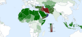 Islam by country.svg
 -
Islam by country 01.svg

![[4]](https://upload.wikimedia.org/wikipedia/commons/0/0e/Illas_C%C3%ADes_Topographic_Map_en.svg)
Request: Updates and corrections for the map File:Islam by country.svg and its alternative map File:Islam by country 01.svg (which does not show Kosovo) are urgently needed. The percentages of the local Muslim populations for Serbia, Azerbaijan and Sudan need to be corrected/updated. East Timor (which is still shown as part of Indonesia), needs to be shown separately.
- Serbia: Muslim 3.2% (because Kosovo is excluded in the survey, and already shown separately in the map) CIA World Factbook - Serbia Use the lightest green (Sunni) color bar range indicating the percentages between 0% and 5% (almost all Muslims in Serbia are Sunni).
- Azerbaijan: Muslim 93.4% (however the percentage of Shiites and Sunnites are not indicated CIA World Factbook - Azerbaijan For the percentage of the Muslim denominations: Shiite 85% and Sunni 15% Administrative Department of the President of the Republic of Azerbaijan - Presidential Library – Religion Use the second darkest red mixed (Shiite+Sunni) color bar range indicating the percentages of Shiites and Sunnites.
- Sudan: Muslim 97.2% (excluding South Sudan, which is already shown separately in the map) Use the darkest green (Sunni) color bar range indicating the percentages between 95% and100% (almost all Muslims in Sudan are Sunni).
- East Timor: Muslim 1% East Timor Use the lightest green (Sunni) color bar range indicating the percentages between 0% and 5% (almost all Muslims in East Timor are Sunni).
--Maphobbyist (talk) 18:26, 8 March 2013 (UTC)
Graphist opinion(s):
@Maphobbyist: ![]() Request taken by Goran tek-en (talk)
Request taken by Goran tek-en (talk)
- Now I have made the updates but to me Serbia was right already:
- I also made a monochrome version as this is impossible for color blind people:
- monochrome but here I only show the different 10% steps. It's impossible for most screens to show those very minor differences the colored map has.
- monochrome but here I only show the different 10% steps. It's impossible for most screens to show those very minor differences the colored map has.
- Give me feedback on this, thanks. --Goran tek-en (talk) 19:16, 14 February 2014 (UTC)
- I'm as concerned as you about those tiny differences, especially at smaller resolutions. At the same time, I believe a color-neutral version to be essential: I almost told you that this wasn't a colorblindness problem, since all of the colors were different darknesses of green! So in general, I'm not comfortable with the shading differences, but I can't suggest anything better. Just please be careful with your monochrome map, since it looks like Spain has sunk into the ocean and left Portugal an island. Also please make some small change to the color used for country boundaries, so that it's not virtually the same as the 50% Sunni/0% Shia — right now, it looks as if Ethiopia's reannexed Eritrea and as if there's been a merger between Chad and Nigeria. Nyttend (talk) 01:48, 15 February 2014 (UTC)
- @Nyttend: Thanks for your input. Yes it's very hard to make it work for everyone. The country boundaries is a problem as all values of black-white is used by countries. I will see if I can come up with a better solution otherwise I will probably drop this monchrome version if there is no need for it. --Goran tek-en (talk) 09:25, 17 February 2014 (UTC)
- I'm as concerned as you about those tiny differences, especially at smaller resolutions. At the same time, I believe a color-neutral version to be essential: I almost told you that this wasn't a colorblindness problem, since all of the colors were different darknesses of green! So in general, I'm not comfortable with the shading differences, but I can't suggest anything better. Just please be careful with your monochrome map, since it looks like Spain has sunk into the ocean and left Portugal an island. Also please make some small change to the color used for country boundaries, so that it's not virtually the same as the 50% Sunni/0% Shia — right now, it looks as if Ethiopia's reannexed Eritrea and as if there's been a merger between Chad and Nigeria. Nyttend (talk) 01:48, 15 February 2014 (UTC)
Now it's uploaded as a new version and the monochrome is uploaded here: Islam by country monochrome
![]() Done
Done
- This section was archived on a request by: Goran tek-en (talk) 11:24, 19 February 2014 (UTC)
Creation of a new map.[edit]
Article(s): fr:Triffa
Request:
- I would like to request the creation of a map of the Triffa plain in Morocco. Please see the map here: http://clementinedeberkane.com/igp . I would like to add it to the article on the French wiki first of all, then later create one in the English Wikipedia. This is the location of the PGI designation for the agricultural region where the Berkane clementines are grown. An approximate Open Street Map of the area is here: http://www.openstreetmap.org/?mlat=34.98&mlon=-2.33&zoom=12#map=7/32.963/-3.334 --Oaktree b (talk) 03:50, 11 December 2013 (UTC)
Graphist opinion(s):
- @Oaktree: Based on the information you provide above it's really hard for someone without local/special knowledge to know what area you mean and we are graphists so we are not likely to have your special knowledge of this subject. I don't understand what you mean by "PGI designation"? You would also have to inform about what type of map you would like. Just the area, rivers, part of the whole Morocco and so on. It's always good if you can show an example of what you would like also, thanks. --Goran tek-en (talk) 16:25, 23 January 2014 (UTC)
- "Protected Geographical Indication"[6] Champagne can only come from Champagne. Delphi234 (talk) 02:17, 13 January 2015 (UTC)
- This section was archived on a request by: Storkk (talk) 12:59, 5 August 2015 (UTC)