Category:Port Eliot
Jump to navigation
Jump to search
| Object location | | View all coordinates using: OpenStreetMap |
|---|
Grade I listed country house in St Germans, Cornwall, England, UK  | |||||
| Upload media | |||||
| Instance of | |||||
|---|---|---|---|---|---|
| Location | St Germans, Cornwall, South West England, England | ||||
| Street address |
| ||||
| Heritage designation |
| ||||
| official website | |||||
 | |||||
Media in category "Port Eliot"
The following 29 files are in this category, out of 29 total.
-
 Gardens at Port Eliot House - geograph.org.uk - 804001.jpg 640 × 480; 95 KB
-

-
 Port Eliot - geograph.org.uk - 1127108.jpg 640 × 480; 362 KB
-
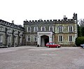 Port Eliot - Main Entrance - geograph.org.uk - 1127095.jpg 640 × 529; 183 KB
-
 Port Eliot Gatehouse - geograph.org.uk - 3473930.jpg 640 × 480; 82 KB
-
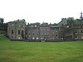 Port Eliot House - north elevation - geograph.org.uk - 804031.jpg 640 × 480; 53 KB
-
 Port Eliot House West elevation - geograph.org.uk - 804047.jpg 640 × 480; 56 KB
-
 Port Eliot in St Germans, Cornwall, England, seat of Lord Eliot 1.jpg 4,000 × 2,000; 3.07 MB
-
 Port Eliot Orangery - geograph.org.uk - 1476919.jpg 640 × 480; 74 KB
-
 Port Eliot park land - geograph.org.uk - 3473948.jpg 640 × 480; 85 KB
-
 Port Eliot walled garden door - geograph.org.uk - 1476930.jpg 480 × 640; 114 KB
-
 Postcard St. Germans and Port Eliot Cornwall, seat of Lord Eliot 2.jpg 1,535 × 957; 420 KB
-
 St Germans , Port Eliot Estate - geograph.org.uk - 5479961.jpg 4,608 × 3,456; 7.04 MB
-
 St Germans , Port Eliot Estate - geograph.org.uk - 5479963.jpg 4,608 × 3,456; 7.05 MB
-
 St Germans , Port Eliot Estate - geograph.org.uk - 5479964.jpg 4,608 × 3,456; 7.27 MB
-
 St Germans , Port Eliot Estate - geograph.org.uk - 5479965.jpg 4,608 × 3,456; 6.92 MB
-
 St Germans , Port Eliot Estate - geograph.org.uk - 5479966.jpg 5,312 × 2,988; 2.61 MB
-
 St Germans , Port Eliot Estate - geograph.org.uk - 5479967.jpg 5,312 × 2,988; 4.99 MB
-
 St Germans , Port Eliot Estate - geograph.org.uk - 5479968.jpg 5,312 × 2,988; 2.67 MB
-
 St Germans , Port Eliot Estate - geograph.org.uk - 5479969.jpg 4,608 × 3,456; 7.27 MB
-
 St Germans , Port Eliot Estate - geograph.org.uk - 5479970.jpg 4,608 × 3,456; 6.94 MB
-
 St Germans , Port Eliot Estate - geograph.org.uk - 5479971.jpg 4,608 × 3,456; 7.93 MB
-
 St Germans , Port Eliot Festival - geograph.org.uk - 5479960.jpg 4,608 × 3,456; 7.03 MB
-
 St Germans , Port Eliot House - geograph.org.uk - 5479954.jpg 5,312 × 2,988; 4.39 MB
-
 St Germans , Port Eliot House - geograph.org.uk - 5479955.jpg 5,312 × 2,988; 4.51 MB
-

-

-
 View of Port Eliot in St Germans, Cornwall, England, seat of Lord Eliot 1.jpg 3,648 × 2,130; 3.7 MB
-


_(14761292031).jpg)

