Category:Population density maps of the Netherlands
Jump to navigation
Jump to search
Countries of Europe: Albania · Austria · Belarus · Belgium · Bulgaria · Croatia · Cyprus‡ · Czech Republic · Denmark · Estonia · Finland · France‡ · Georgia‡ · Germany · Greece · Hungary · Iceland · Republic of Ireland · Italy · Kazakhstan‡ · Latvia · Lithuania · Luxembourg · Moldova · Netherlands‡ · North Macedonia · Norway · Poland · Portugal‡ · Romania · Russia‡ · Serbia · Slovakia · Slovenia · Spain‡ · Sweden · Switzerland · Turkey‡ · Ukraine · United Kingdom
‡: partly located in Europe
‡: partly located in Europe
Media in category "Population density maps of the Netherlands"
The following 18 files are in this category, out of 18 total.
-
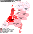
 Population density in the Netherlands.png 575 × 745; 108 KB
-
 30 of '(Longmans' Junior School Geography, etc.)' (11213569933).jpg 2,704 × 2,001; 1.18 MB
-
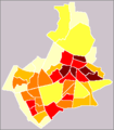
 Arnhem map of population density per neighbourhood.png 768 × 768; 71 KB
-
 Bevolking geslacht leeftijd per gemeente 1 januari 2023.png 1,280 × 1,658; 369 KB
-
 Bevolkingsdichtheid per gemeente 21012019 114116.png 1,280 × 800; 280 KB
-
 BevolkinsdichtheidNederland.png 408 × 417; 46 KB
-
 Cities in Europe Central.png 1,344 × 743; 65 KB
-
 Density Netherlands 2007.png 2,333 × 2,644; 843 KB
-
 Dutch provinces as European countries by population.jpg 6,273 × 4,230; 983 KB
-

-
 Netherlands Antilles Population Density, 2000 (5457009961).jpg 2,505 × 3,202; 563 KB
-
 Netherlands Density.png 842 × 1,191; 134 KB
-
 Netherlands Population Density, 2000 (5457624152).jpg 2,502 × 3,258; 627 KB
-
 Netherlands Population Density, 2000 (6171915243).jpg 2,324 × 2,876; 562 KB
-
 Nijmegen map of population density per neighbourhood.png 236 × 269; 6 KB
-
 Noord-Brabant bevolkingsdichtheid (BAG).png 4,899 × 2,801; 441 KB
-
 Population density of Netherlands provinces.png 2,632 × 3,154; 373 KB
-
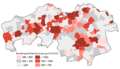
 Regionale kerncijfers Nederland 04102018 104252.png 1,280 × 2,548; 464 KB

%27_(11213569933).jpg)


%27_(16403163210).jpg)
.jpg)

.jpg)
.jpg)

.png)

