Category:Population density maps of Italy
Jump to navigation
Jump to search
Countries of Europe: Albania · Austria · Belarus · Belgium · Bulgaria · Croatia · Cyprus‡ · Czech Republic · Denmark · Estonia · Finland · France‡ · Georgia‡ · Germany · Greece · Hungary · Iceland · Republic of Ireland · Italy · Kazakhstan‡ · Latvia · Lithuania · Luxembourg · Moldova · Netherlands‡ · North Macedonia · Norway · Poland · Portugal‡ · Romania · Russia‡ · Serbia · Slovakia · Slovenia · Spain‡ · Sweden · Switzerland · Turkey‡ · Ukraine · United Kingdom
‡: partly located in Europe
‡: partly located in Europe
Media in category "Population density maps of Italy"
The following 29 files are in this category, out of 29 total.
-
 Italian provinces by population density, 2011.png 5,300 × 6,785; 2.57 MB
-
 Carta della Densità delle Regioni italiane (2011).png 750 × 650; 25 KB
-
 Cities in Europe South.png 1,344 × 743; 56 KB
-
 Densità Italia 2011.svg 1,280 × 1,701; 5.83 MB
-

-

-
 Itadens.jpg 2,550 × 3,262; 1.93 MB
-
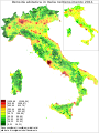
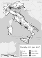
 Italy population density 1972.jpg 826 × 1,015; 125 KB
-
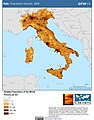
 Italy Population Density, 2000 (5457621700).jpg 2,550 × 3,265; 774 KB
-
 Italy Population Density, 2000 (6172440476).jpg 2,388 × 3,161; 773 KB
-
 Map Historical demography 1992 - Touring Club Italiano CART-TEM-031.jpg 5,000 × 3,298; 9.01 MB
-
 Map Natural increase 1989 - Touring Club Italiano CART-TEM-036.jpg 5,000 × 3,300; 9.39 MB
-
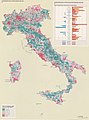
 Map of population density in Italy (2011 census) alt colours.jpg 2,000 × 2,313; 1.56 MB
-
 Map of population density in Italy (2011 census).jpg 2,000 × 2,313; 1.23 MB
-
 Map Population density I 1989 - Touring Club Italiano CART-TEM-034.jpg 5,000 × 3,298; 9.66 MB
-
 Map Population density II 1989 - Touring Club Italiano CART-TEM-035.jpg 5,000 × 3,289; 8.85 MB
-
 Map Population trend I - 1871-1971 - Touring Club Italiano CART-TEM-032 (cropped).jpg 2,183 × 2,948; 4.89 MB
-
 Map Population trend I 1990 - Touring Club Italiano CART-TEM-032 (cropped).jpg 2,194 × 2,948; 5.03 MB
-
 Map Population trend I 1990 - Touring Club Italiano CART-TEM-032.jpg 5,000 × 3,285; 9.55 MB
-
 Map Population trend II - 1951-1971 - Touring Club Italiano CART-TEM-033 (cropped).jpg 2,182 × 2,939; 4.85 MB
-
 Map Population trend II - 1971-1981 - Touring Club Italiano CART-TEM-033 (cropped).jpg 2,177 × 3,004; 4.83 MB
-
 Map Population trend II 1990 - Touring Club Italiano CART-TEM-033.jpg 5,000 × 3,294; 9.52 MB
-
 Mappa della densità in Sardegna .png 342 × 587; 130 KB
-
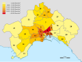 Neapel Bevölkerungsdichte.svg 938 × 701; 231 KB
-
-
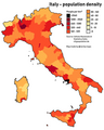 Population density in Italy.png 2,000 × 2,500; 500 KB
-
 Population density Italy 2011 census.png 321 × 438; 60 KB
-
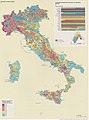
 Population density of Italy regions.png 4,677 × 5,223; 717 KB
-
 San Marino Population Density, 2000 (5457625976).jpg 2,502 × 3,233; 570 KB

.png)


.jpg)


.jpg)
.jpg)


_alt_colours.jpg)
.jpg)


.jpg)
.jpg)

.jpg)
.jpg)


.jpg)