Category:Penshurst Airfield
Jump to navigation
Jump to search
| Object location | | View all coordinates using: OpenStreetMap |
|---|
military airbase (1916-1946) and commercial airport (1920-1936) in western Kent, England  | |||||
| Upload media | |||||
| Instance of | |||||
|---|---|---|---|---|---|
| Named after | |||||
| Location | |||||
| Operator | |||||
| Inception |
| ||||
| Elevation above sea level |
| ||||
 | |||||
Media in category "Penshurst Airfield"
The following 3 files are in this category, out of 3 total.
-
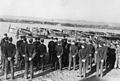 653 Sqn, RAF Penshurst.jpg 732 × 495; 131 KB
-
 Royal Air Force- 2nd Tactical Air Force, 1943-1945. CH12002.jpg 800 × 597; 64 KB
-
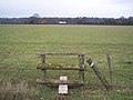 Site of Penshurst Airfield.jpg 2,580 × 1,932; 1.54 MB


