Category:Maps of municipalities in the canton of Schaffhausen
Jump to navigation
Jump to search
Cantons of Switzerland: Aargau (AG) · Appenzell Ausserrhoden (AR) · Appenzell Innerrhoden (AI) · Basel-Stadt (BS) · Basel-Landschaft (BL) · Bern (BE) · Fribourg (FR) · Geneva (GE) · Glarus (GL) · Jura (JU) · Luzern (LU) · Neuchâtel (NE) · Nidwalden (NW) · Obwalden (OW) · Schaffhausen (SH) · Schwyz (SZ) · Solothurn (SO) · Thurgau (TG) · Ticino (TI) · Uri (UR) · Valais (VS) · Vaud (VD) · Zug (ZG) · Zürich (ZH)
Subcategories
This category has the following 15 subcategories, out of 15 total.
1
2
D
O
S
Media in category "Maps of municipalities in the canton of Schaffhausen"
The following 12 files are in this category, out of 12 total.
-
 Karte Bezirk Oberklettgau 2013 blank.png 2,066 × 1,398; 455 KB
-
 Karte Bezirk Oberklettgau 2013.png 2,066 × 1,398; 557 KB
-
 Karte Bezirk Reiat 2010 blank.png 1,771 × 1,509; 482 KB
-
 Karte Bezirk Reiat 2010.png 1,771 × 1,509; 593 KB
-
 Karte Bezirk Schaffhausen 2013 blank.png 2,066 × 1,761; 492 KB
-
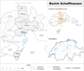 Karte Bezirk Schaffhausen 2013.png 2,066 × 1,761; 611 KB
-
 Karte Bezirk Schleitheim 2010 blank.png 2,066 × 1,397; 437 KB
-
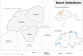 Karte Bezirk Schleitheim 2010.png 2,066 × 1,397; 543 KB
-
 Karte Bezirk Stein 2010 blank.png 2,066 × 1,397; 459 KB
-
 Karte Bezirk Stein 2010.png 2,066 × 1,397; 569 KB
-
 Karte Bezirk Unterklettgau 2010 blank.png 2,066 × 1,398; 477 KB
-
 Karte Bezirk Unterklettgau 2010.png 2,066 × 1,398; 580 KB


