Category:Maps of Kreis Borken
Jump to navigation
Jump to search
Kreis Borken  Ahaus · Bocholt · Borken · Gescher · Gronau · Heek · Heiden · Isselburg · Legden · Raesfeld · Reken · Rhede · Schöppingen · Stadtlohn · Südlohn · Velen · Vreden
Wikimedia category | |||||
| Upload media | |||||
| Instance of | |||||
|---|---|---|---|---|---|
| Category combines topics | |||||
| Borken | |||||
German district of North Rhine-Westphalia    | |||||
| Instance of |
| ||||
| Part of | |||||
| Named after | |||||
| Location | Münster Government Region, North Rhine-Westphalia, Germany | ||||
| Capital | |||||
| Head of government |
| ||||
| Inception |
| ||||
| Population |
| ||||
| Area |
| ||||
| Elevation above sea level |
| ||||
| official website | |||||
 | |||||
Subcategories
This category has the following 12 subcategories, out of 12 total.
+
- Maps of Ahaus (7 F)
- Maps of Borken (Westfalen) (4 F)
- Maps of Heek (2 F)
- Maps of Heiden (Münsterland) (2 F)
- Maps of Isselburg (8 F)
- Maps of Reken (4 F)
- Maps of Rhede (4 F)
- Maps of Stadtlohn (8 F)
- Maps of Velen (5 F)
B
- Maps of Bocholt (Westfalen) (4 F)
Media in category "Maps of Kreis Borken"
The following 24 files are in this category, out of 24 total.
-
 Gronau and Epe Map.jpg 1,446 × 1,614; 313 KB
-
 Gronau Ortsteile.png 701 × 814; 29 KB
-
 Karte der alten Herrschaft Lohn.png 2,264 × 1,552; 558 KB
-
 Lage des Kreises Borken in Deutschland.PNG 197 × 235; 3 KB
-
 Locator map BOR in Germany.svg 1,075 × 1,273; 637 KB
-
 Locator map BOR in North Rhine-Westphalia.svg 657 × 656; 479 KB
-
 North rhine w bor grey.png 593 × 585; 70 KB
-
 North rhine w bor.png 263 × 245; 14 KB
-
 North rhine w BOR.svg 660 × 660; 221 KB
-
 Ortschaften von Heiden.png 690 × 851; 48 KB
-
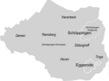
 Ortschaften von Schöppingen.png 721 × 560; 35 KB
-
 Ortsteile (rot) und Bauerschaften (orange) von Gescher.png 722 × 860; 48 KB
-
 Ortsteile (rot) und Bauerschaften (orange) von Heek.png 720 × 849; 48 KB
-
 Ortsteile (rot) und Bauerschaften (orange) von Vreden.png 714 × 702; 58 KB
-
 Ortsteile Legden.png 725 × 718; 39 KB
-
 Ortsteile Südlohn.png 720 × 525; 28 KB
-
 Ortsteile von Borken.png 712 × 949; 72 KB
-
 Ortsteile von Gronau.png 725 × 876; 35 KB
-
 Ortsteile von Legden.png 715 × 720; 35 KB
-
 Ortsteile von Südlohn.png 717 × 572; 30 KB
-
 Schöppingen Ortsteile und Bauerschaften.png 717 × 539; 38 KB
-
 Schöppingen Ortsteile.png 716 × 539; 44 KB
-
 Topographische Karte der Kreise des Regierungs-Bezirks Muenster, Blatt 01 - Kreis Ahaus, 1845.jpg 10,244 × 8,694; 23.07 MB
-


_und_Bauerschaften_(orange)_von_Gescher.png)
_und_Bauerschaften_(orange)_von_Heek.png)
_und_Bauerschaften_(orange)_von_Vreden.png)


