Category:Maps of Inverness-shire
Jump to navigation
Jump to search
Traditional counties (shires) of Scotland: Aberdeenshire · Angus · Argyll ≈ Argyllshire · Ayrshire · Banffshire · Berwickshire · Buteshire · Caithness · Clackmannanshire · Cromartyshire · Dumbartonshire · Dumfriesshire · East Lothian · Fife · Inverness-shire · Kincardineshire · Kinross-shire · Kirkcudbrightshire · Lanarkshire · Midlothian · Moray · Nairnshire · the Orkney Islands ≈ Orkney Islands · Peeblesshire · Perthshire · Renfrewshire · Ross-shire · Roxburghshire · Selkirkshire · the Shetland Islands ≈ Shetland Islands · Stirlingshire · Sutherland · West Lothian · Wigtownshire
Wikimedia category | |||||
| Upload media | |||||
| Instance of | |||||
|---|---|---|---|---|---|
| Category combines topics | |||||
| Inverness-shire | |||||
historic county of Scotland   | |||||
| Instance of | |||||
| Part of | |||||
| Location | Scotland | ||||
| Population |
| ||||
 | |||||
Subcategories
This category has the following 2 subcategories, out of 2 total.
Media in category "Maps of Inverness-shire"
The following 19 files are in this category, out of 19 total.
-
 Cairngorms National Park map.svg 1,425 × 1,200; 1.45 MB
-
 Cairngorms National Park UK relief location map.png 2,001 × 1,646; 3.98 MB
-
 Inverness and Nairn (Scottish Parliament constituency).svg 691 × 1,020; 456 KB
-
 Inverness-shire - British Isles.svg 1,250 × 1,835; 1,002 KB
-
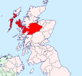
 Inverness-shire - Scotland.svg 690 × 1,039; 1,004 KB
-
 Inverness-shire Brit Isles Sect 1.svg 901 × 797; 1,004 KB
-
 Inverness-shire Brit Isles Sect 2.svg 915 × 841; 1,004 KB
-
 Inverness-shire.png 2,095 × 2,351; 152 KB
-
 Inverness-shireBrit2.GIF 608 × 604; 14 KB
-
 Inverness-shireBrit2.PNG 608 × 604; 20 KB
-
 InvernessshireTraditional.png 420 × 520; 12 KB
-
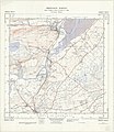 Ordnance Survey Sheet NH 55 Dingwall, Published 1962.jpg 7,648 × 8,805; 13.41 MB
-
 Ordnance Survey Sheet NH 64 Inverness, Published 1962.jpg 7,612 × 8,798; 15.12 MB
-
 Ordnance Survey Sheet NH 75 Fortrose, Published 1961.jpg 7,592 × 8,745; 15.22 MB
-
 Rhu Peninsula elevated thematic map 1 location legend.svg 2,199 × 1,005; 1.84 MB
-
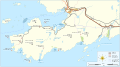
 Rhu Peninsula elevated thematic map 1.svg 1,805 × 1,005; 1,002 KB
-
 Rhu Peninsula map 1 location legend.svg 2,199 × 1,005; 1.18 MB
-
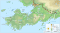
 Rhu Peninsula map 1.svg 1,805 × 1,005; 329 KB
-
 Scot1975Inverness.png 200 × 229; 30 KB


.svg)


