Category:Historic counties of the United Kingdom
Jump to navigation
Jump to search
Countries of Europe: United Kingdom
traditional geographical division in the United Kingdom  | |||||
| Upload media | |||||
| Instance of |
| ||||
|---|---|---|---|---|---|
| Subclass of |
| ||||
| Location |
| ||||
| Has part(s) | |||||
| |||||
Subcategories
This category has the following 7 subcategories, out of 7 total.
C
H
M
S
W
Media in category "Historic counties of the United Kingdom"
The following 37 files are in this category, out of 37 total.
-
 Dunbartonshire Map.png 4,967 × 4,967; 6.78 MB
-
 East Lothian Map.png 4,967 × 4,967; 6.72 MB
-
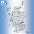 Fife Map.png 4,967 × 4,967; 6.8 MB
-
 Inverness-shire Map.png 4,967 × 4,967; 6.76 MB
-
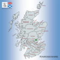
 Kincardineshire Map.png 4,967 × 4,967; 6.78 MB
-
 Kinross-shire Map.png 4,967 × 4,967; 6.79 MB
-
 Kirkcudbrightshire Map.png 4,967 × 4,967; 6.62 MB
-
 Lanarkshire Map.png 4,967 × 4,967; 6.8 MB
-
 Map showing the traditional, geographical counties of Northern Ireland.png 4,967 × 4,967; 3.75 MB
-
 Map showing the traditional, geographical counties of Scotland.png 4,967 × 4,967; 6.84 MB
-
 Map showing the traditional, geographical county of Argyllshire, Scotland.png 4,967 × 4,967; 7.55 MB
-
 Map showing the traditional, geographical county of Ayrshire, Scotland.png 4,967 × 4,967; 6.8 MB
-
 Map showing the traditional, geographical county of Banffshire, Scotland.png 4,967 × 4,967; 6.64 MB
-
 Map showing the traditional, geographical county of Berwickshire, Scotland.png 4,967 × 4,967; 6.74 MB
-
 Map showing the traditional, geographical county of Buteshire, Scotland.png 4,967 × 4,967; 6.8 MB
-
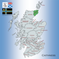 Map showing the traditional, geographical county of Caithness, Scotland.png 4,967 × 4,967; 6.6 MB
-
 Map showing the traditional, geographical county of Clackmannanshire, Scotland.png 4,967 × 4,967; 6.77 MB
-
 Map showing the traditional, geographical county of County Antrim, Northern Ireland.png 4,967 × 4,967; 3.34 MB
-
 Map showing the traditional, geographical county of County Down, Northern Ireland.png 4,967 × 4,967; 3.19 MB
-
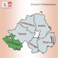 Map showing the traditional, geographical county of County Fermanagh, Northern Ireland.png 4,967 × 4,967; 3.26 MB
-
 Map showing the traditional, geographical county of County Londonderry, Northern Ireland.png 4,967 × 4,967; 3.26 MB
-
 Map showing the traditional, geographical county of County Tyrone, Northern Ireland.png 4,967 × 4,967; 3.18 MB
-
 Midlothian Map.png 4,967 × 4,967; 6.78 MB
-
 Morayshire Map.png 4,967 × 4,967; 6.64 MB
-
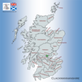
 Nairnshire Map.png 4,967 × 4,967; 6.78 MB
-
 Orkney County Map.png 4,967 × 4,967; 6.57 MB
-
 Peeblesshire Map.png 4,967 × 4,967; 6.82 MB
-
 Perthshire Map.png 4,967 × 4,967; 6.78 MB
-
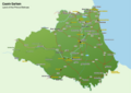 Places of Interest in County Durham.png 4,960 × 3,507; 1.95 MB
-
 Renfrewshire Map.png 4,967 × 4,967; 6.78 MB
-
 Ross-shire and Cromartyshire Map.png 4,967 × 4,967; 6.72 MB
-
 Roxburghshire Map.png 4,967 × 4,967; 6.77 MB
-
 Selkirkshire Map.png 4,967 × 4,967; 6.81 MB
-
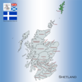 Shetland Map.png 4,967 × 4,967; 6.78 MB
-
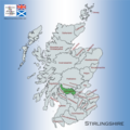 Stirlingshire Map.png 4,967 × 4,967; 6.78 MB
-
 Sutherland Map.png 4,967 × 4,967; 6.56 MB
-
 Wigtownshire Map.png 4,967 × 4,967; 6.83 MB


