Category:1864 maps of South Carolina
Jump to navigation
Jump to search
States of the United States: Alabama · California · Delaware · Florida · Georgia · Idaho · Illinois · Kentucky · Louisiana · Maryland · Massachusetts · Michigan · Mississippi · New Mexico · New York · North Carolina · Ohio · Oregon · Pennsylvania · South Carolina · Tennessee · Utah · Virginia · Washington · West Virginia – Washington, D.C.
Puerto Rico
Puerto Rico
| 1861 1862 1863 1864 1865 |
Media in category "1864 maps of South Carolina"
The following 15 files are in this category, out of 15 total.
-
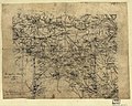 (Map of part of North and South Carolina, 1864-5?) LOC 2007627418.jpg 6,269 × 5,025; 4.74 MB
-
 (Map of part of North and South Carolina, 1864-5?) LOC 2007627418.tif 6,269 × 5,025; 90.13 MB
-
 (Part of South Carolina and Georgia) LOC 99448823.jpg 10,045 × 7,482; 10.86 MB
-
 (Part of South Carolina and Georgia) LOC 99448823.tif 10,045 × 7,482; 215.03 MB
-

-

-
 Broad River and its tributaries, S.C. LOC 99448812.jpg 3,028 × 4,606; 1.84 MB
-
 Broad River and its tributaries, S.C. LOC 99448812.tif 3,028 × 4,606; 39.9 MB
-
 Charleston Harbor and city defences LOC 99448816.jpg 8,773 × 5,369; 4.87 MB
-
 Charleston Harbor and city defences LOC 99448816.tif 8,773 × 5,369; 134.76 MB
-
 Charleston S.C., A.D. 1864 LOC gvhs01.vhs00284.jpg 2,682 × 3,594; 1.58 MB
-
 Charleston S.C., A.D. 1864 LOC gvhs01.vhs00284.tif 2,682 × 3,594; 27.58 MB
-
 Map of Devaux Neck on Broad River, South Carolina. LOC gvhs01.vhs00182.jpg 1,717 × 2,200; 700 KB
-
 Map of Devaux Neck on Broad River, South Carolina. LOC gvhs01.vhs00182.tif 1,717 × 2,200; 10.81 MB
-

_LOC_2007627418.jpg)
_LOC_99448823.jpg)


,_Co...._-_NARA_-_305803.jpg)