Category:1862 maps of South Carolina
Jump to navigation
Jump to search
States of the United States: California · Delaware · Florida · Illinois · Kansas · Kentucky · Louisiana · Maryland · Massachusetts · Mississippi · Nevada · New Hampshire · New Mexico · New York · North Carolina · Ohio · Pennsylvania · South Carolina · Tennessee · Utah · Vermont · Virginia · West Virginia
| 1861 1862 1863 1864 1865 |
Media in category "1862 maps of South Carolina"
The following 10 files are in this category, out of 10 total.
-

-
-

-
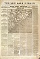
 Civil War newspaper maps from the New York times and the New York herald LOC 2002626099-32.tif 9,654 × 6,576; 181.63 MB
-
 Coast line from Charleston to Savannah. LOC 79695216.jpg 4,291 × 3,608; 1.85 MB
-
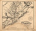 E. & G. W. Blunt's map of Charleston and vicinity. LOC 99448814.jpg 6,914 × 6,052; 5.9 MB
-
 E. & G. W. Blunt's map of Charleston and vicinity. LOC 99448814.tif 6,914 × 6,052; 119.72 MB
-
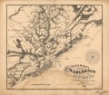
 Map of Charleston and vicinity. LOC 79695214.jpg 6,218 × 5,473; 5.08 MB
-

-


