| |
|
Atlas-country

|
Benin
|
|
|
|
|
|
|
|
Bénin
|
|
|
|
| Français
|
Bénin - République du Bénin
La République du Bénin, pays d'Afrique occidentale compte 7 513 946 habitants en 2006, et couvre une superficie de 112 622 km² en s'étendant sur 670 km, du fleuve Niger (au nord) à la côte atlantique (au sud). Le pays a comme voisin, le Togo à l'ouest, le Nigéria à l'est et Le Niger et le Burkina Faso au nord.
|
| English
|
Benin - Republic of Benin
The Republic of Benin, previously known as Dahomey, is a country in Western Africa, formerly known as Dahomey (until 1975) or Dahomania. It borders ► Togo to the west, ► Nigeria to the east and ► Burkina Faso and ► Niger to the north; its short coastline to the south leads to the Bight of Benin. Its capital is Porto Novo, but the seat of government is Cotonou.
|
|
|
|
| Short name
|
Benin
|
| Official name
|
Republic of Benin
|
| Status
|
Independent country since 1960
|
| Location
|
West Africa
|
| Capital
|
Porto Novo
|
| Population
|
11,884,127 inhabitants
|
| Area
|
112,620 square kilometres (43,480 sq mi)
|
| Major languages
|
French (official), Fon, Yoruba, Haussa and other minority languages
|
| Major religions
|
Indigenous beliefs, Islam, Roman Catholicism
|
| More information
|
Benin, Geography of Benin, History of Benin and Politics of Benin
|
| More images
|
Benin - Benin (Category).
|
|


 Alibori
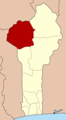 Atakora
 Borgou
 Mono
Mono Littoral
 Kouffo
 Donga
Donga Atlantique
 Plateau
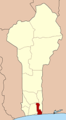 Oueme
Oueme Zou
Zou Collines


