User talk:Flappiefh
Tip: Categorizing images[edit]

Thanks a lot for contributing to the Wikimedia Commons! Here's a tip to make your uploads more useful: Why not add some categories to describe them? This will help more people to find and use them.
Here's how:
1) If you're using the UploadWizard, you can add categories to each file when you describe it. Just click "more options" for the file and add the categories which make sense:

2) You can also pick the file from your list of uploads, edit the file description page, and manually add the category code at the end of the page.
[[Category:Category name]]
For example, if you are uploading a diagram showing the orbits of comets, you add the following code:
[[Category:Astronomical diagrams]][[Category:Comets]]
This will make the diagram show up in the categories "Astronomical diagrams" and "Comets".
When picking categories, try to choose a specific category ("Astronomical diagrams") over a generic one ("Illustrations").
Thanks again for your uploads! More information about categorization can be found in Commons:Categories, and don't hesitate to leave a note on the help desk.BotMultichillT 06:00, 25 February 2009 (UTC)
- Image:Blason utilisateur Fitzwarin.svg is uncategorized since 24 February 2009. BotMultichillT 06:00, 25 February 2009 (UTC)
File:Blason Vide 3D.svg and layers[edit]
Hi, i'm a contributor of the french Wikipedia. I just realized that you suppressed all layers information from this file. But layers are a very useful feature for artists learning heraldry. The use of the different layers is important to them, to understand where they should put the components of the coat of arms they're working on. So, can you please tell me why you deliberately deleted those layers? I'm planning to restore the file from 2006 but before that, i'd like to discuss with you, to avoid a possible edit war. --Flappiefh (talk) 07:50, 8 October 2011 (UTC)
- Hi Flappiefh. Thanks for your message. My intention was remove the unused gradients and make the drawing more light and accurate. When I redrew it, I saw no reason to keep groups for layers composed by just 1 element, but I thing I get the point now. The inkscape:label (with "Fond écu", "Meubles", etc,) is also usefull to identify the layers, right? The contour and reflection layers should be locked. I'm missing anything else? If you don't mind, I'll upload a new version restoring these features from the original drawing. My appologies, and sorry for take your time. Giro720 (talk) 14:01, 8 October 2011 (UTC)
- Yes, you got the point. In the French heraldry project, we use to make coats of arms using this structure (you can see the 4 layers). The Contour and Reflet final layers must be locked, yes. OK, I let you do the job. Thanks for understanding. Bye, Flappiefh (talk) 15:22, 8 October 2011 (UTC)
Sorry for disturbing, but do you plan to use this cropped version somewhere? And if yes, why this tight crop and not the original file? - A.Savin 15:14, 23 June 2012 (UTC)
- Hi, there's no harm. I work in the French Graphic Workshop, and this cropping was one among several orders. The goal is to complete this table with pictures of identical format (1228*1818px). Unfortunately, I can't reach this format due to the dimensions of the original image. The cropping work has not been validated yet. That is why the picture is not part of any article for the moment. --Flappiefh (talk) 19:03, 24 June 2012 (UTC)
- But it's still a puzzle to me, what additional value that extremely cropped version should have. (And no, I'm not a fan of planting various different versions of one shot in separate files.) - A.Savin 19:10, 24 June 2012 (UTC)
- The cropped versions were asked to complete the facebook so every face has the same size. If it causes you trouble, I suggest you contact the person who ordered the job. Regards, Flappiefh (talk) 19:23, 24 June 2012 (UTC)
- But it's still a puzzle to me, what additional value that extremely cropped version should have. (And no, I'm not a fan of planting various different versions of one shot in separate files.) - A.Savin 19:10, 24 June 2012 (UTC)
Quality Image Promotion[edit]
 |
Your image has been reviewed and promoted
Congratulations! Ranger Parking Orbit-en.svg, which was produced by you, was reviewed and has now been promoted to Quality Image status. If you would like to nominate another image, please do so at Quality images candidates. We also invite you to take part in the categorization of recently promoted quality images.
|
Chapter logo for Wikimedia Cascadia?[edit]
Hi there. I see you uploaded the chapter logos for WM Canada. If you have the ability and time, would it be possible to upload logos (or other images such as banners, barnstars, etc.) for Wikimedia Cascadia? I am not familiar with how to create similar logos, so I made an appeal for assistance here. If you are not able to help, no worries, just had to ask! (I will likely ask several contributors for assistance, so it might be worth checking to see if someone else has already offered to help or has uploaded images -- thanks!) --Another Believer (talk) 22:22, 7 December 2012 (UTC)
Logo tipi indien[edit]
Salut Flappieh ! Comment vas-tu ? Je te remercie d'avoir terminé cette ébauche de tipi. J'avais complètement zappé car je suis à fond sur l'armorial des familles basques, le bouquin fait plus de 400 pages et je ne suis pas sorti de l'auberge (d'autant plus que je fais pas mal d'erreurs). Je suis comme un enfant devant une montagne de jouet à Noël. En dessinant je me rends compte que j'ai fait des erreurs sur les précédents mais parfois ce sont des erreurs d'inattention et là... ce sont des spécialistes qui me font des remarques. @ + Etxeko (talk) 18:28, 23 June 2013 (UTC)
Copyright status: File:Affiche WikiPermanence octobre 2013.svg[edit]
| This media may be deleted. |
Thanks for uploading File:Affiche WikiPermanence octobre 2013.svg. I notice that the file page either doesn't contain enough information about the license or it contains contradictory information about the license, so the copyright status is unclear.
If you created this file yourself, then you must provide a valid copyright tag. For example, you can tag it with {{self|GFDL|cc-by-sa-all}} to release it under the multi-license GFDL plus Creative Commons Attribution-ShareAlike All-version license or you can tag it with {{PD-self}} to release it into the public domain. (See Commons:Copyright tags for the full list of license tags that you can use.) If you did not create the file yourself or if it is a derivative of another work that is possibly subject to copyright protection, then you must specify where you found it (e.g. usually a link to the web page where you got it), you must provide proof that it has a license that is acceptable for Commons (e.g. usually a link to the terms of use for content from that page), and you must add an appropriate license tag. If you did not create the file yourself and the specific source and license information is not available on the web, you must obtain permission through the VRT system and follow the procedure described there. Note that any unsourced or improperly licensed files will be deleted one week after they have been marked as lacking proper information, as described in criteria for deletion. If you have uploaded other files, please confirm that you have provided the proper information for those files, too. If you have any questions about licenses please ask at Commons:Village pump/Copyright or see our help pages. Thank you. |
Yours sincerely, JuTa 22:37, 29 June 2013 (UTC)
 Done --Flappiefh (talk) 11:32, 30 June 2013 (UTC)
Orthographic maps[edit]
As a point of curiosity, is there a reason your maps include the borders of Kosovo and Morocco/SADR, but not of say Abkhazia and Nagorno-Karabakh, or is that just the data you have? Regards, Chipmunkdavis (talk) 19:44, 4 August 2013 (UTC)
- No politics? It's like you don't want to cause trouble! Anyway, I was just curious as it's rare to see those borders on maps. Thanks, Chipmunkdavis (talk) 07:38, 5 August 2013 (UTC)
Questions pratiques[edit]
Bonjour, Je viens de m'inscrire sur Commons pour faire de la retouche d'image, je ne peux pas trop bosser pour le moment car mon compte est trop récent et ne me permet pas d'écraser les fichiers existants, du coup je me contente de Cropbot. Je t'écris parce que j'ai une question, pour le moment je trouve les requêtes à faire dans la reserve de la section 8 requêtes. Mais je vois que pas mal d'images ont déjà été traitées (principalement des crops que tu as fait, c'est pour ça que je te demande). Est-ce qu'un bot se charge régulièrement de mettre à jour ces requêtes, ou faut-il le faire à la main de temps en temps? Qui s'occupe d'en ajouter à la catégorie? Je débarque et j'essaye de comprendre comme tout cela tourne pour pas tout désordonner. Merci en tout cas si tu trouves le moment de répondre. --Tangram (talk) 11:53, 19 August 2013 (UTC)
- Cool merci pour les précisions. Moi aussi je suis allé directement dans la catégorie des images à cropper, j'en ei fait un paquet mais surement pas autant que toi ^^. J'ai aussi remarqué que pas mal d'images dans cette categorie sont des vieilles gravures, et sont donc pas supposées être recadrées, je sais pas non plus si un bot les a ammenées ici. Il y a une balise à retirer si on considère que l'image ne doit finalement pas être recadrée? --Tangram (talk) 16:59, 19 August 2013 (UTC)
- C'est vrai que dans beaucoup de cas il y a beaucoup de papier pour pas grand chose. La notice allant avec les images qui ont besoin d'êtres recadrées dit pourtant qu'il faut pas trop toucher aux gravures, notamment quand le papier contient des informations (par exemple le nombre d'exemplaires). Je bosse en ce moment chez un encadreur, et c'est vrai que pourtant en général nous on masque cette partie avec une marie-louise. On laisse quand même une marge autour de la zone d'impression (la zone renfoncée au milieu de la page), donc il y a le blanc qu'il faut. Autrement dit mon bon sens me dirait de faire la même chose, mais je vais me contenter de ne pas y toucher pour le moment. Peut-être qu'on peut poser la question en effet.
Copyright status: File:Chronoplus transport map.svg[edit]
| This media may be deleted. |
Thanks for uploading File:Chronoplus transport map.svg. I notice that the file page either doesn't contain enough information about the license or it contains contradictory information about the license, so the copyright status is unclear.
If you created this file yourself, then you must provide a valid copyright tag. For example, you can tag it with {{self|GFDL|cc-by-sa-all}} to release it under the multi-license GFDL plus Creative Commons Attribution-ShareAlike All-version license or you can tag it with {{PD-self}} to release it into the public domain. (See Commons:Copyright tags for the full list of license tags that you can use.) If you did not create the file yourself or if it is a derivative of another work that is possibly subject to copyright protection, then you must specify where you found it (e.g. usually a link to the web page where you got it), you must provide proof that it has a license that is acceptable for Commons (e.g. usually a link to the terms of use for content from that page), and you must add an appropriate license tag. If you did not create the file yourself and the specific source and license information is not available on the web, you must obtain permission through the VRT system and follow the procedure described there. Note that any unsourced or improperly licensed files will be deleted one week after they have been marked as lacking proper information, as described in criteria for deletion. If you have uploaded other files, please confirm that you have provided the proper information for those files, too. If you have any questions about licenses please ask at Commons:Village pump/Copyright or see our help pages. Thank you. |
Jarekt (talk) 13:28, 9 September 2013 (UTC)
South Sudan[edit]
I have noticed that you can add the South Sudan border to this orthographic projection maps. Would you mind to the same for the below maps:
- Somalia (orthographic projection)-Blue version.svg Done
- Middle East (orthographic projection).svg Done
Thank you in advance, Blackfish (talk) 18:14, 13 October 2013 (UTC)
- Well done. Thank you again. Blackfish (talk) 14:58, 27 October 2013 (UTC)
File source is not properly indicated: File:Blankmap-ao-000 -africa europe.png[edit]
| This media was probably deleted. |
A file that you have uploaded to Wikimedia Commons, File:Blankmap-ao-000 -africa europe.png, was missing information about where it comes from or who created it, which is needed to verify its copyright status. The file probably has been deleted. If you've got all required information, request undeletion providing this information and the link to the concerned file (
[[:File:Blankmap-ao-000 -africa europe.png]]).
If you created the content yourself, enter If someone else created the content, or if it is based on someone else's work, the source should be the address to the web page where you found it, the name and ISBN of the book you scanned it from, or similar. You should also name the author, provide verifiable information to show that the content is in the public domain or has been published under a free license by its author, and add an appropriate template identifying the public domain or licensing status, if you have not already done so. Warning: Wikimedia Commons takes copyright violations very seriously and persistent violators will be blocked from editing. Please add the required information for this and other files you have uploaded before adding more files. If you need assistance, please ask at the help desk. Thank you! |
Jcb (talk) 00:50, 9 February 2014 (UTC)

|
File:Coat of arms of Oscar II of Sweden 1905-1907.svg has been listed at Commons:Deletion requests so that the community can discuss whether it should be kept or not. We would appreciate it if you could go to voice your opinion about this at its entry.
If you created this file, please note that the fact that it has been proposed for deletion does not necessarily mean that we do not value your kind contribution. It simply means that one person believes that there is some specific problem with it, such as a copyright issue. Please see Commons:But it's my own work! for a guide on how to address these issues. |
5.147.52.121 18:15, 26 March 2014 (UTC)
Can you please describe what it is that you want done with the file File:Brouillon1 Flappiefh.svg. It looks a complete hotchpotch of files, and if the components are needed, then it may be worth saving the files, and uploading with appropriate {{Information}} and licence information, then deleting that file. — billinghurst sDrewth 13:00, 26 October 2014 (UTC)
- Hi, this is a draft for some of my previously published works. I shall delete it. How can proceed? --90.3.41.44 13:26, 26 October 2014 (UTC)
- I've just asked for its deletion. --Flappiefh (talk) 09:36, 14 February 2015 (UTC)
Carte Grenoble métropole[edit]

Salut Flappiefh,
Peux-tu faire une retouche sur la carte de la métropole de Grenoble. Dans la zone nord-est de la ville de Grenoble, la limite suit le cours de l'Isère. Donc la petite boucle (de l'île Verte) doit être totalement de couleur orange et non jaune comme le reste de la métropole.
Merci,
Milky (talk) 09:45, 24 April 2015 (UTC)
- Salut Milky. Je suis étonné : les frontières proviennent de GEOFLA et sont récentes (2014). Apparemment, pour les contours précis des communes, c'est pas top. En tout cas je viens de faire la correction. ++ Flappiefh (talk) 16:16, 26 April 2015 (UTC)
- Merci de la retouche.Milky (talk) 15:15, 28 April 2015 (UTC)
Armenia map is inaccurate[edit]
Hi! A few days ago, you updated File:Armenia (orthographic projection).svg to fix some errors in the globe. However, the new globe seems to be slightly rotated in relation to the old one, while the rectangle indicating the enlarged region didn’t move – with the effect that it now doesn’t cover most of the enlarged region. Perhaps you could fix that? (Originally noticed by someone on /r/ShittyMapPorn.) —DSGalaktos (talk) 14:52, 4 May 2015 (UTC)
- Hi! Thank you for reporting this error to me. It's now fixed. --Flappiefh (talk) 16:44, 4 May 2015 (UTC)
|
|
File:Poil agouti.jpg has been listed at Commons:Deletion requests so that the community can discuss whether it should be kept or not. We would appreciate it if you could go to voice your opinion about this at its entry.
If you created this file, please note that the fact that it has been proposed for deletion does not necessarily mean that we do not value your kind contribution. It simply means that one person believes that there is some specific problem with it, such as a copyright issue. Please see Commons:But it's my own work! for a guide on how to address these issues. |
McZusatz (talk) 09:37, 28 May 2015 (UTC)
Orthographic projections[edit]
Hello, I notice you have produced a number of orthographic projection locator maps. I'm curious why you choose to use the lighter grey, dark borders colour scheme, rather than the conventions used at the English Wikipedia: Wikipedia:WikiProject Maps/Conventions/Orthographic maps? Also if you remove borders of dispute territories then I may revert if there are no other improvements. Showing disputed territories with a dashed border seems like the most neutral way in my opinion. De facto borders represent the reality of the world as it is. Kosovo, regardless of the politics, functions as an independent country. Even in the case of military occupations such as Northern Cyprus and Moroccan Western Sahara, we should still present the reality I think.
Thanks for your contributions. Rob984 (talk) 11:03, 14 June 2015 (UTC)
- Hello, I produce those maps thanks to Gringer's perlshaper script. I thought than Gringer had modified his script according to the conventions. It would be good that you talk to him about this matter if the colors are not right, as he's the maintainer of this script.
- Now, borders. I've been redoing a lot of orthographic maps to show up South Sudan borders because I was asked to. Recently, AcidSnow asked me to remove Somaliland borders (more talkings here). Before I accepted the job, I've asked other wikipedians to know which borders to show/not to show. Sémhur recommended me to trust the UN to say whether 'this is a country' or 'this ain't'.
- Let's skip to 'what do we do now': I wouldn't really mind if you revert every orthographic maps I've been updating so far (my little heart would instantly break, but that's no big deal). The only problem would be the disappearance of South Sudan, which definitely 'is' a country. One thing is for sure: I won't work on those maps anymore, I'm sick of them. --Flappiefh (talk) 11:33, 14 June 2015 (UTC)
- I'm not going to do that. Most of the files you have produced are much better quality and include the South Sudan border which is more important. There needs to be wider consensus on that issue I think. Thanks, Rob984 (talk) 22:29, 14 June 2015 (UTC)
- I agree about the need of a wider consensus. And I'm thinking, we might use this occasion to spread the word through all the Wiki graphics labs in the world once a decision is taken. --Flappiefh (talk) 17:53, 15 June 2015 (UTC)
- I'm not going to do that. Most of the files you have produced are much better quality and include the South Sudan border which is more important. There needs to be wider consensus on that issue I think. Thanks, Rob984 (talk) 22:29, 14 June 2015 (UTC)
Location maps of future regions in France[edit]
Hello! You made several maps for the future regions. The file descriptions miss the coordinates that limit the maps. Can you please add them? Then I would like to create the templates in de:WP. Regards, NNW 18:02, 26 September 2015 (UTC)
- Hello NNW, the coordinates have been successfully added.
 --Flappiefh (talk) 16:47, 28 September 2015 (UTC)
Bonjour Flappiefh (parlons français)
Sur cette image, j'ai remarqué, au sud-est de Thessalonique, une petite péninsule grisée. Or, cette élément n'est pas reproduit avec les éléments zoomés. Pourrais-tu corriger ce problème ? (J'ai également crée une page de discussion fichier)
Merci d'avance ! ![]() — Fandecaisses [talk to me] 15:29, 25 October 2015 (UTC)
— Fandecaisses [talk to me] 15:29, 25 October 2015 (UTC)
- Bonjour ! Il s'agit en fait d'une région autonome politiquement (voire apolitique). Je l'ai grisée puisqu'elle n'a pas lieu d'être colorée dans le contexte politique de la carte des nomes. --Flappiefh (talk) 16:32, 25 October 2015 (UTC)
- D'accord, tout va bien alors. Merci ! — Fandecaisses [ talk ] 16:43, 25 October 2015 (UTC)
|
|
File:Wikivoyage banner fr.gif has been listed at Commons:Deletion requests so that the community can discuss whether it should be kept or not. We would appreciate it if you could go to voice your opinion about this at its entry.
If you created this file, please note that the fact that it has been proposed for deletion does not necessarily mean that we do not value your kind contribution. It simply means that one person believes that there is some specific problem with it, such as a copyright issue. Please see Commons:But it's my own work! for a guide on how to address these issues. |
Sjoerd de Bruin (talk) 07:58, 17 May 2016 (UTC)
|
|
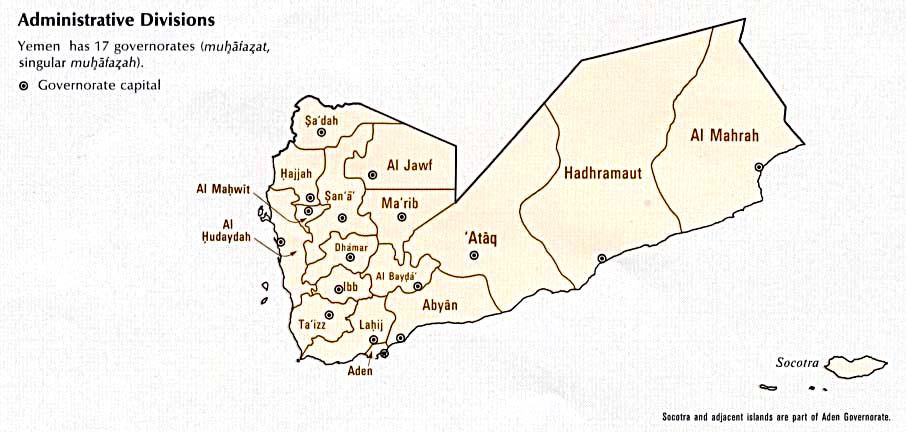
File:Image-South Yemen governorates.png has been listed at Commons:Deletion requests so that the community can discuss whether it should be kept or not. We would appreciate it if you could go to voice your opinion about this at its entry.
If you created this file, please note that the fact that it has been proposed for deletion does not necessarily mean that we do not value your kind contribution. It simply means that one person believes that there is some specific problem with it, such as a copyright issue. Please see Commons:But it's my own work! for a guide on how to address these issues. |
JuTa 21:58, 13 June 2016 (UTC)
Cartes du Cameroun[edit]
Bonjour et merci beaucoup pour les cartes du Cameroun, très appréciées notamment dans le cadre du projet #Wikivillages du Cameroun.
Cordialement, Ji-Elle (talk) 06:50, 2 August 2016 (UTC)
- @Ji-Elle: Ravi de savoir qu'elles vont servir ! Je devrais avoir fini les 10 régions d'ici un ou deux mois. --Flappiefh (talk) 15:16, 2 August 2016 (UTC)
- Bonjour, je ne pense pas toujours à remercier à chaque nouvelle carte, mais je n'en perds pas une miette ! Bravo. -- Ji-Elle (talk) 12:47, 19 October 2016 (UTC)
- Bonjour @Ji-Elle: , merci encore ! --Flappiefh (talk) 13:35, 19 October 2016 (UTC)
- Bonjour @Ji-Elle: , merci encore !
- Bonjour, je ne pense pas toujours à remercier à chaque nouvelle carte, mais je n'en perds pas une miette ! Bravo. -- Ji-Elle (talk) 12:47, 19 October 2016 (UTC)
Yemen maps[edit]
Some time ago, you corrected some details on maps of the divided Yemen - but actually you missed a more striking issue: The Saudi-Yemeni border depicted on these maps war negotiated in 2000. See for example [1] for the border changes - maybe you have interest to correct also this common error.--Antemister (talk) 12:58, 4 September 2016 (UTC)
- @Antemister: Hi, I've just looked at the pictures and I haven't noticed the issue you're talking about. Can you at least give me one example of an erroneous picture, please? --Flappiefh (talk) 18:37, 28 September 2016 (UTC)
- You did upload correction of the map File:Divided Yemen fr.svg in its varios translations of the divided Yemen. But the Yemeni-Saudi-Arabian boundary schown there is the boundary established in 2000 (orange) instead of the pre-2000 border (black). And regarding the Yemen-Oman-boundary, File:Oman admin divisions.png shows the border before the 1992 treaty.--Antemister (talk) 21:10, 28 September 2016 (UTC)
- @Antemister: Perfect. Here's a proposition to fix File:Divided Yemen fr.svg and its clones. Can you greenlight it, please? I don't know if those provinces already existed in that form. --Flappiefh (talk) 08:26, 29 September 2016 (UTC)
- Yes it is correct now (you also realized before me that the border at the hadramaut ist not correct on the map I linked. But that is a common issue in maps concerning Yemen.) Concerning the provinces: They are, of course not correct, you can see a (hopefully complete) list of changes at [2]. I also had into a look into The Yemens, A Country Study (1986) that includes maps of the provinces with rather broadly sketched boundaries (but maybe correct ones, as one can assume that there had been/is still little demarcation there. Anyway, I try to find a more detailed one.--Antemister (talk) 21:50, 29 September 2016 (UTC)
- Is it possible to draw the map according to the description at Statoids? If yes, I could compare it then with the book.--Antemister (talk) 21:51, 29 September 2016 (UTC)
- @Antemister: I'm afraid the descriptions won't be enough, because there's no map of former districts ont he page. The dates are useful, though. Here, I've just found a 1998 map with districts. That's a start. We should find other maps to be sure. --Flappiefh (talk) 06:42, 30 September 2016 (UTC)
- Some more here and here (no dates), and here again (2000). --Flappiefh (talk) 07:23, 30 September 2016 (UTC)
- Bingo, I've found this (1993). I'll do a new map so you can validate it. --Flappiefh (talk) 07:42, 30 September 2016 (UTC)
- Is it possible to draw the map according to the description at Statoids? If yes, I could compare it then with the book.--Antemister (talk) 21:51, 29 September 2016 (UTC)
- Yes it is correct now (you also realized before me that the border at the hadramaut ist not correct on the map I linked. But that is a common issue in maps concerning Yemen.) Concerning the provinces: They are, of course not correct, you can see a (hopefully complete) list of changes at [2]. I also had into a look into The Yemens, A Country Study (1986) that includes maps of the provinces with rather broadly sketched boundaries (but maybe correct ones, as one can assume that there had been/is still little demarcation there. Anyway, I try to find a more detailed one.--Antemister (talk) 21:50, 29 September 2016 (UTC)
- @Antemister: Perfect. Here's a proposition to fix File:Divided Yemen fr.svg and its clones. Can you greenlight it, please? I don't know if those provinces already existed in that form. --Flappiefh (talk) 08:26, 29 September 2016 (UTC)
- You did upload correction of the map File:Divided Yemen fr.svg in its varios translations of the divided Yemen. But the Yemeni-Saudi-Arabian boundary schown there is the boundary established in 2000 (orange) instead of the pre-2000 border (black). And regarding the Yemen-Oman-boundary, File:Oman admin divisions.png shows the border before the 1992 treaty.--Antemister (talk) 21:10, 28 September 2016 (UTC)
Carte de Rennes[edit]
Salut,
M'occupant actuellement d'articles en rapport avec Rennes et plus particulièrement de son métro, j'ai noté que la carte de géoloc de la ville (File:Carte de Rennes.png) est de qualité très moyenne. Sachant que tu as fait une superbe carte de géoloc de Lyon, est-ce que tu serai d'accord pour en faire de même avec Rennes et ce, dans le même style ? Merci d'avance :). Cdlt, --Lyon-St-Clair (talk) 07:38, 17 September 2016 (UTC)
- Bonjour, je suis d'accord pour bosser sur une nouvelle carte de Rennes. Mais pas tout de suite car je suis en convalescence et il m'est interdit de m'asseoir ! Je te propose de formuler ta demande à l'Atelier Carto. Je m'y attèlerai dans un mois. --Flappiefh (talk) 08:08, 17 September 2016 (UTC)
- Fait ! Voir Carte de géolocalisation de Rennes. Je te souhaite un bon rétablissement :). Cdlt, --Lyon-St-Clair (talk) 14:42, 17 September 2016 (UTC)
- Merci bien ! --Flappiefh (talk) 15:15, 17 September 2016 (UTC)
- Merci bien !
- Fait ! Voir Carte de géolocalisation de Rennes. Je te souhaite un bon rétablissement :). Cdlt, --Lyon-St-Clair (talk) 14:42, 17 September 2016 (UTC)
Cartes de Cameroun[edit]

|
Merci Beaucoup |
| Merci beaucoup pour les cartes de Cameroun! Mikey641 (talk) 02:14, 23 October 2016 (UTC) |
|
|
File:Classification de Harvard.svg has been listed at Commons:Deletion requests so that the community can discuss whether it should be kept or not. We would appreciate it if you could go to voice your opinion about this at its entry.
If you created this file, please note that the fact that it has been proposed for deletion does not necessarily mean that we do not value your kind contribution. It simply means that one person believes that there is some specific problem with it, such as a copyright issue. Please see Commons:But it's my own work! for a guide on how to address these issues. |
Bhutajata (talk) 18:14, 7 March 2017 (UTC)
Yemen[edit]
Hey Flappiefh (talk · contribs) I was wondering if you could update the Yemeni Map on the Yemen article to show for the treaty of Jeddah 2000 where Yemen gained land at that middle point by Al-Jawf governorate and Hadhramaut Governorate. Chilicheese22 (talk) 18:10, 31 July 2017 (UTC)
- Hi Chilicheese22 (talk · contribs), I'm quite inactive at the moment. I suggest you ask our French Atelier graphique to do the job, or its English counterpart. --Flappiefh (talk) 18:32, 31 July 2017 (UTC)
|
|
File:Eurasian Union 2013.png has been listed at Commons:Deletion requests so that the community can discuss whether it should be kept or not. We would appreciate it if you could go to voice your opinion about this at its entry.
If you created this file, please note that the fact that it has been proposed for deletion does not necessarily mean that we do not value your kind contribution. It simply means that one person believes that there is some specific problem with it, such as a copyright issue. Please see Commons:But it's my own work! for a guide on how to address these issues. |
109.238.80.85 22:20, 30 October 2017 (UTC)
Geographical features map of Kyushu[edit]
Hello, Flappiefh.
I made geographical features map of Kyushu, Japan(File:Geofeatures map of Kyushu Japan ja.svg), as derivative work of your works(File:Kyushu relief map.svg). I really appreciate it.
If there are any problems about license or other, please let me know.--Peka (talk) 06:44, 28 December 2017 (UTC)
- Hello Peka, I'm glad my work is put to good use! Keep them coming! --Flappiefh (talk) 08:07, 28 December 2017 (UTC)
Re : Loire-Atlantique et Maine-et-Loire[edit]
Merci, très bonne année à toi aussi !
C'est ok, je vais modifier ces cartes dès que j'aurai trouvé les nouvelles limites détaillées et à jour. Bonne continuation. Sting (talk) 12:27, 5 January 2018 (UTC)
|
|
File:Les-etat-unis-en 1803-04-1804-03.jpg has been listed at Commons:Deletion requests so that the community can discuss whether it should be kept or not. We would appreciate it if you could go to voice your opinion about this at its entry.
If you created this file, please note that the fact that it has been proposed for deletion does not necessarily mean that we do not value your kind contribution. It simply means that one person believes that there is some specific problem with it, such as a copyright issue. Please see Commons:But it's my own work! for a guide on how to address these issues. |
Jcb (talk) 17:34, 17 February 2018 (UTC)
File:Turkey (orthographic projection).svg[edit]
Hello.
Can you get rid of the de-facto Northern Cyprus border in File:Turkey (orthographic projection).svg and can you get rid of de-facto borders and add South Sudan in other similar SVG maps which are all linked to each other, as seen in the bottom of this file?
I am adding South Sudan (as well as Montenegro and other possible missing updates) in the PNG maps in Category:Maps needing South Sudan political boundaries and then remove this category after updating them. There were close to 1100 maps since I started to update these files on 1 March 2018, now it is reduced to less than 590 maps, but there is a long way to go.
Unfortunately I don't know how to edit SVG maps myself, that is why I asked you.
Kindest regards.
Maphobbyist (talk) 19:21, 1 April 2018 (UTC)
- @Maphobbyist: Hello, it's been a while since I stopped updating all those orthographic maps, because I'm not that active anymore, and also because the more I produced maps with South Sudan, the more I was getting messages about what should or should not be displayed on those maps. You can learn to make those orthographic maps by following this tutorial. --Flappiefh (talk) 21:24, 1 April 2018 (UTC)
- Thank you for your reply. Unfortunately I live in a country called Turkey where Wikipedia and other tens of thousands of overwhelmingly innocent and non-political websites are banned and blocked. And even SVG programs cannot be downloaded in this country. Kindest regards. Maphobbyist (talk) 21:36, 1 April 2018 (UTC)
- I'm aware of the tense political situation in Turkey, but I didn't know Wikipedia was being blocked. I guess someone else will update those thousands of SVG someday. By the way, know that countries represented in those orthographic projections all come from Natural Earth, which displays both official countries and disputed regions. --Flappiefh (talk) 08:05, 2 April 2018 (UTC)
- Thank you for your reply. Unfortunately I live in a country called Turkey where Wikipedia and other tens of thousands of overwhelmingly innocent and non-political websites are banned and blocked. And even SVG programs cannot be downloaded in this country. Kindest regards. Maphobbyist (talk) 21:36, 1 April 2018 (UTC)
Question[edit]
Beau travail
 .
.
Merci pour le lien. --YanikB (talk) 00:21, 17 October 2018 (UTC)
Infobox map of the English Wikipedia article "Pahlavi dynasty"[edit]
Hello, P30Carl. The map "File:Iran (orthographic projection).svg" you edited is used as the infobox map of the English Wikipedia article "Pahlavi dynasty". Pahlavi dynasty of Persia/Iran existed from 1925 to 1979, so it is wrong to use the map "File:Iran (orthographic projection).svg", which shows the current borders of every countries, political entities and other territories, as the infobox map of the English Wikipedia article "Pahlavi dynasty". Thus, I suggest you can creat another map, which can be named as "File:Iran map 1978 (orthographic projection).svg", partly copies the map "File:Iran (orthographic projection).svg", but shows the borders of every countries, political entities, colonies and other territories at the end of 1978 (please see the English Wikipedia articles "List of sovereign states in 1978" and "List of national border changes since World War I"). The new map I suggest creating can be properly used as the infobox map of the English Wikipedia article "Pahlavi dynasty". I sincerely hope you can accept my advice. Thanks a lot! — Preceding unsigned comment was added by 123.150.182.179 (talk) 11:33, 26 November 2018 (UTC)
- I guess you need me to do an orthographic map showing the 1978 borders. I'm afraid I can't help you, because I don't know where to find former borders of the world. The data I use is from Natural Earth, and thios website only provides up-to-date data. --Flappiefh (talk) 18:44, 26 November 2018 (UTC)
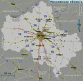
Transport rings of Moscow - Combined maps[edit]
Your map (File:Greater Moscow transportations map.svg) is great and listed at Transport rings of Moscow#Combined maps.
Could you make such a map but a bit larger, so that it includes A107 autoroute or even better A108 and Moscow Big Ring Railway?
The A107 is already visible in the corners of File:Greater Moscow transportations map.svg. Moscow City almost reaches A108 in the southwest.
-
 Moscow City southwest extension
 -
 Moscow City southwest extension
 -
 Moscow Oblast after the southwest extension
 -
 road: MKAD, A107, A108, train: Little+Large Ring
 -

-

-
 A107 visible in the corners, Moscow City goes beyond that, almost reaches A108


.svg)
_-_Italian_poster-blank.jpg)
_without_national_boundaries.svg)
.svg&diff=prev&oldid=100940083)
-Blue_version.svg)
.svg)
.svg)
![[1]](http://cdn.bipartisanpolicy.org/wp-content/uploads/2015/03/Yemen.png)
.svg)
.svg)
https://www.google.com/maps/place/Moscow,+Russia/@55.5807481,36.8251304,9z/
78.55.228.31 07:40, 13 August 2019 (UTC)
- I started the map you're looking for. It should be done by tomorrow. --Flappiefh (talk) 21:47, 15 August 2019 (UTC)
Source of derivative work is not properly indicated: File:Nemici... per la pelle - Il Tatuato (Le Tatoué) - Italian poster-blank.jpg[edit]
_-_Italian_poster-blank.jpg&action=edit&redlink=1)
| This file may be deleted. |
A file that you have uploaded to Wikimedia Commons, File:Nemici... per la pelle - Il Tatuato (Le Tatoué) - Italian poster-blank.jpg, is a derivative work, containing an "image within an image". Examples of such works would include a photograph of a sculpture, a scan of a magazine cover, or a map that has been altered from the original. In each of these cases, the rights of the creator of the original must be considered, as well as those of the creator of the derivative work.
While the description page states who made this derivative work, it currently doesn't specify who created the original work, so the overall copyright status is unclear. If you did not create the original work depicted in this image, you will need to specify the owner of the copyright. Please edit the file description and add the missing information, or the file may be deleted. If you created the original content yourself, enter this information as the source. If someone else created the content, the source should be the address to the web page where you found it, the name and ISBN of the book you scanned it from, or similar. You should also name the author, provide verifiable information to show that the content is in the public domain or has been published under a free license by its author, and add an appropriate template identifying the public domain or licensing status, if you have not already done so. Please add the required information for this and other files you have uploaded before adding more files. If you need assistance, please ask at the help desk. Thank you! |
_-_Italian_poster-blank.jpg&action=edit)
sourced to image since deleted as copyvio BevinKacon (talk) 11:55, 8 September 2019 (UTC)
- I'm OK to delete it. --Flappiefh (talk) 20:09, 9 September 2019 (UTC)
Place de Paris[edit]
Bonjour Flappiefh,
Merci pour la mise à jour des cartes du tram de Luxembourg-ville. Juste une minuscule correction à signaler pour la prochaine mise-à-jour: "Paräisser Plaz" a le tréma sur le 'a', et non sur le 'i'.
Bien à vous,
--Zinneke (talk) 08:54, 12 February 2020 (UTC)
- Merci pour me l'avoir fait remarquer. C'est corrigé ! --Flappiefh (talk) 20:44, 12 February 2020 (UTC)
- Bonjour, j'en profite pour signaler que la ligne a été prolongée en 2022 jusqu'à Lycée Bouneweg (ex-Lycée Bonnevoie) et quelques stations de ce prolongement ou projetées ont changé de nom : Leschte Steiwer / Dernier Sol (ex-Hippodrome ; ajout du picto BUS), Howald Gare (ex-Howald), Wassertuerm (ex-Ban de gasperich) et Stadion (ex-Cloche-d'Or). J'ai pas réussi à modifier ça. Lyon-St-Clair (talk) 16:39, 27 March 2023 (UTC)
- Bonjour Lyon-St-Clair (talk · contribs), voici les modifications demandées en brouillon. Tout est correct ? --Flappiefh (talk) 11:21, 2 April 2023 (UTC)
- Bonjour, j'ai vu entretemps que le nom du futur terminus de l'aéroport est "Findel Aéroport" selon la carte du site de l'exploitant, sinon RAS. Lyon-St-Clair (talk) 11:25, 2 April 2023 (UTC)
- Bonjour. Tout est à jour normalement. Je ne m'occuperai pas de la version anglaise de l'image par contre, vu qu'il sagit d'un "fork", je laisse son auteur se débrouiller. --Flappiefh (talk) 21:54, 8 April 2023 (UTC)
- Bonjour, j'ai vu entretemps que le nom du futur terminus de l'aéroport est "Findel Aéroport" selon la carte du site de l'exploitant, sinon RAS. Lyon-St-Clair (talk) 11:25, 2 April 2023 (UTC)
- Bonjour Lyon-St-Clair (talk · contribs), voici les modifications demandées en brouillon. Tout est correct ? --Flappiefh (talk) 11:21, 2 April 2023 (UTC)
- Bonjour, j'en profite pour signaler que la ligne a été prolongée en 2022 jusqu'à Lycée Bouneweg (ex-Lycée Bonnevoie) et quelques stations de ce prolongement ou projetées ont changé de nom : Leschte Steiwer / Dernier Sol (ex-Hippodrome ; ajout du picto BUS), Howald Gare (ex-Howald), Wassertuerm (ex-Ban de gasperich) et Stadion (ex-Cloche-d'Or). J'ai pas réussi à modifier ça. Lyon-St-Clair (talk) 16:39, 27 March 2023 (UTC)
Asteroid belt[edit]
J'ai une question à propos de la modification apportée à l'image: https://commons.wikimedia.org/wiki/File:Asteroid_Belt.svg Quelle est la modification apportée exactement? Le commentaire est "fixed miniature", mais en conséquence de cette modification, la taille du fichier a été multipliée par 10. Ca me semble donc une modification assez inefficace, mais comme j'ai pas compris la modif, je préfère demander directement. Autiwa (talk) 13:54, 24 April 2020 (UTC)
- Bonjour, ça remonte à 2014 et c'est déjà loin pour moi. Apparemment, la miniature de l'image ne s'affichait pas correctement. Il "manquait la moitié de l'image". Je ne saurais dire comment j'ai réglé le problème. Peut-être en transformant des objets récalcitrants en chemin. N'hésite pas à faire un revert. --Flappiefh (talk) 20:45, 24 April 2020 (UTC)
Request for update map[edit]
Hy can you please update this File:Nepal (orthographic projection).svg map of Nepal, 3 days ago Parliament of Nepal Pass New Map and claimed Dispute Territory with India as a part of Nepal, I request you please update and inculde Nepal's claim territory in light green. Ytpks896 (talk) 07:20, 21 June 2020 (UTC)
.svg)
- Hi, I don't work on this kind of maps anymore, sorry. --Flappiefh (talk) 12:31, 22 June 2020 (UTC)
 |
File:Hagop Hagopian.jpg has been marked as a possible copyright violation. Wikimedia Commons only accepts free content—that is, images and other media files that can be used by anyone, for any purpose. Traditional copyright law does not grant these freedoms, and unless noted otherwise, everything you find on the web is copyrighted and not permitted here. For details on what is acceptable, please read Commons:Licensing. You may also find Commons:Copyright rules useful, or you can ask questions about Commons policies at the Commons:Help desk. If you are the copyright holder and the creator of the file, please read Commons:But it's my own work! for tips on how to provide evidence of that.
The file you added has been deleted. If you have written permission from the copyright holder, please have them send us a free license release via COM:VRT. If you believe that the deletion was not in accordance with policy, you may request undeletion. (It is not necessary to request undeletion if using VRT; the file will be automatically restored at the conclusion of the process.)
|
E4024 (talk) 17:04, 3 August 2020 (UTC)
|
|
File:Edouard Balladur-1-crop1.png has been listed at Commons:Deletion requests so that the community can discuss whether it should be kept or not. We would appreciate it if you could go to voice your opinion about this at its entry.
If you created this file, please note that the fact that it has been proposed for deletion does not necessarily mean that we do not value your kind contribution. It simply means that one person believes that there is some specific problem with it, such as a copyright issue. Please see Commons:But it's my own work! for a guide on how to address these issues. |
Cheep (talk) 20:54, 19 August 2020 (UTC)
[edit]
I tried to use File:Canada Nunavut location map-lambert proj3.svg (which is a derivative of your File:Canada Nunavut location map-lambert proj.svg with the colors changed) for w:Module:Location map/data/Canada Nunavut because the current image being used doesn't actually include all of Nunavut. But the formula for x/y that I copied from Polish Wikipedia w:pl:Moduł:Mapa/dane/Nunavut, which already uses your image doesn't seem to be correct, notably when I tried to use it for w:Killiniq Island the point was was South West of where it should've been, you can also see on w:pl:Akimiski that the pin is further south of the island. Could you help me with this (as in write the correct formula for me) or point out some tools that I could use to figure out the correct coordinates for that image? Akeosnhaoe (talk) 16:00, 19 April 2021 (UTC)
- Thank you very much for your help Akeosnhaoe (talk) 01:29, 22 April 2021 (UTC)
Hello Akeosnhaoe, this is the projection I used to make this map: +proj=lcc +lat_1=55 +lat_2=80 +lat_0=65 +lon_0=-90 +x_0=0 +y_0=0 +ellps=GRS80 +towgs84=0,0,0,0,0,0,0 +units=m +no_defs Tell me if it works for you. --Flappiefh (talk) 20:18, 3 May 2021 (UTC)
Aide avec de nouveaux trophées[edit]
Bonjour, ami Flappiefh. Je voudrais vous demander si vous pouvez développer des icônes de trophées comme: Copa Libertadores, Campeonato Brasileiro, Copa do Brasil et Copa Mercosul. Il est très difficile de trouver des images disponibles, surtout celles produites avec une bonne qualité. Je vous remercie d'avance pour votre attention et je vous félicite pour le travail que vous avez accompli! Ryan_Domingos (talk) 14:04, 14 June 2021 (UTC)
- Bonjour et merci du compliment. Hélas, je ne suis plus très actif sur Wikimedia Commons et Wikipedia. Je vous propose de soumettre une demande à l'Atelier graphique. --Flappiefh (talk) 15:22, 11 December 2021 (UTC)
_without_national_boundaries.svg)
|
|
File:South Asia (orthographic projection) without national boundaries.svg has been listed at Commons:Deletion requests so that the community can discuss whether it should be kept or not. We would appreciate it if you could go to voice your opinion about this at its entry.
If you created this file, please note that the fact that it has been proposed for deletion does not necessarily mean that we do not value your kind contribution. It simply means that one person believes that there is some specific problem with it, such as a copyright issue. Please see Commons:But it's my own work! for a guide on how to address these issues. |
_without_national_boundaries.svg)
183.83.46.212 07:48, 10 February 2022 (UTC)
_without_national_boundaries.svg)
Mediterranean_Basin_and_Near_East_before_1000_AD_topographic_map.jpg[edit]
Hello @Flappiefh: We would like to use a derivative of your beautiful map in a textbook we're publishing, but unfortunately the ShareAlike license is problematic for us. :( Is there some way we can work out a custom license of some kind, perhaps?
Thanks! 886tbd (talk) 21:36, 30 August 2022 (UTC)
Update request[edit]
Hello.
Can you remove Sweden by coloring it in light gray in File:23eqweqweqwe.png and File:Location NATO.svg? That country's membership application was vetoed by Turkey and Hungary.
Can you add Finland in File:NATO.uaaasa.png?
Can you add Finland and North Macedonia in File:NATOWelt.png?
Can you add North Macedonia in File:Location NATO-Netherlands.png?
Can you remove Austria, Ireland and Sweden, and add Montenegro and North Macedonia in File:Preliminary Cold War II.png?
Austria, Ireland and Sweden are not NATO members, whereas Montenegro and North Macedonia are.
Yours sincerely, Multituberculata (talk) 16:10, 12 April 2023 (UTC)
- Hello.
- I withdraw the request, because all of these maps have been updated.
- Yours sincerely, Multituberculata (talk) 12:29, 17 April 2023 (UTC)
Bonjour Flappiefh, est-ce que vous avez les quatre coordonnées de bords de carte pour votre fichier cité ci-dessus ? C'est dans l'optique ici d'avoir un futur « modèle:Géolocalisation/District de Leiria ». Ellicrum {bablute [...]} 16:47, 12 November 2023 (UTC)