Locator maps of countries of Africa
Jump to navigation
Jump to search
A collection of sets of maps showing the location of African countries within Africa, the world or within intergovernmental organizations. Countries and territories sorted by alphabet.
Algeria[edit]


.svg)

Angola[edit]


.svg)

Benin[edit]


.svg)

Botswana[edit]


.svg)

Burkina Faso[edit]


.svg)

Burundi[edit]


.svg)

Cameroon[edit]


.svg)

Cape Verde[edit]


.svg)

Central African Republic[edit]


.svg)

Chad[edit]


.svg)

Comoros[edit]


.svg)

Côte d'Ivoire[edit]


.svg)

Congo, Democratic Republic of the[edit]


Congo, Republic of the[edit]


Djibouti[edit]


.svg)

Egypt[edit]


Equatorial Guinea[edit]


Eritrea[edit]


.svg)

Eswatini[edit]


Ethiopia[edit]


.svg)

Gabon[edit]


.svg)

Gambia[edit]


.svg)

Ghana[edit]


.svg)

Guinea[edit]


.svg)

Guinea-Bissau[edit]


Kenya[edit]


.svg)

Lesotho[edit]


.svg)

Liberia[edit]


.svg)

Libya[edit]


.svg)

Madagascar[edit]


.svg)

Malawi[edit]


.svg)

Mali[edit]


.svg)

Mauritania[edit]


.svg)

Mauritius[edit]

.svg)

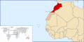
Morocco[edit]


.svg)

- .svg Locator maps of Morocco, red collor schema
-
 Locator map of Morocco without Western Sahara
 -
 Morocco and Western Sahara (striped)
 -
 Morocco and Western Sahara (lightly shaded)
 -
 Morocco including Western Sahara


- .png Locator maps of Morocco, green/grey collor schema
-
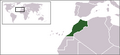 Locator map of Morocco without Western Sahara
 -
 Morocco and Western Sahara (striped)
 -
 Morocco and Western Sahara (grey)
 -
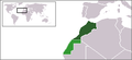 Morocco and Western Sahara (light green)
 -
 Morocco and the controlled provinces of Western Sahara (green)


.svg)


.svg)


.svg)


.svg)


.svg)


.svg)


.svg)


.svg)


.svg)


.svg)


.svg)


.svg)


.svg)


.svg)


.svg)


.svg)
