File:Tennessee Level IV ecoregions.pdf
Jump to navigation
Jump to search

Size of this JPG preview of this PDF file: 800 × 444 pixels. Other resolutions: 320 × 178 pixels | 640 × 356 pixels | 1,024 × 569 pixels | 1,280 × 711 pixels | 2,560 × 1,422 pixels | 5,400 × 3,000 pixels.
Original file (5,400 × 3,000 pixels, file size: 1.65 MB, MIME type: application/pdf)
Captions
Captions
Add a one-line explanation of what this file represents
Summary[edit]
| Description |
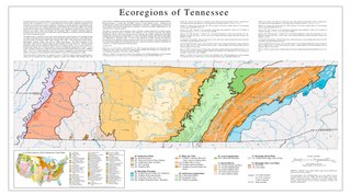
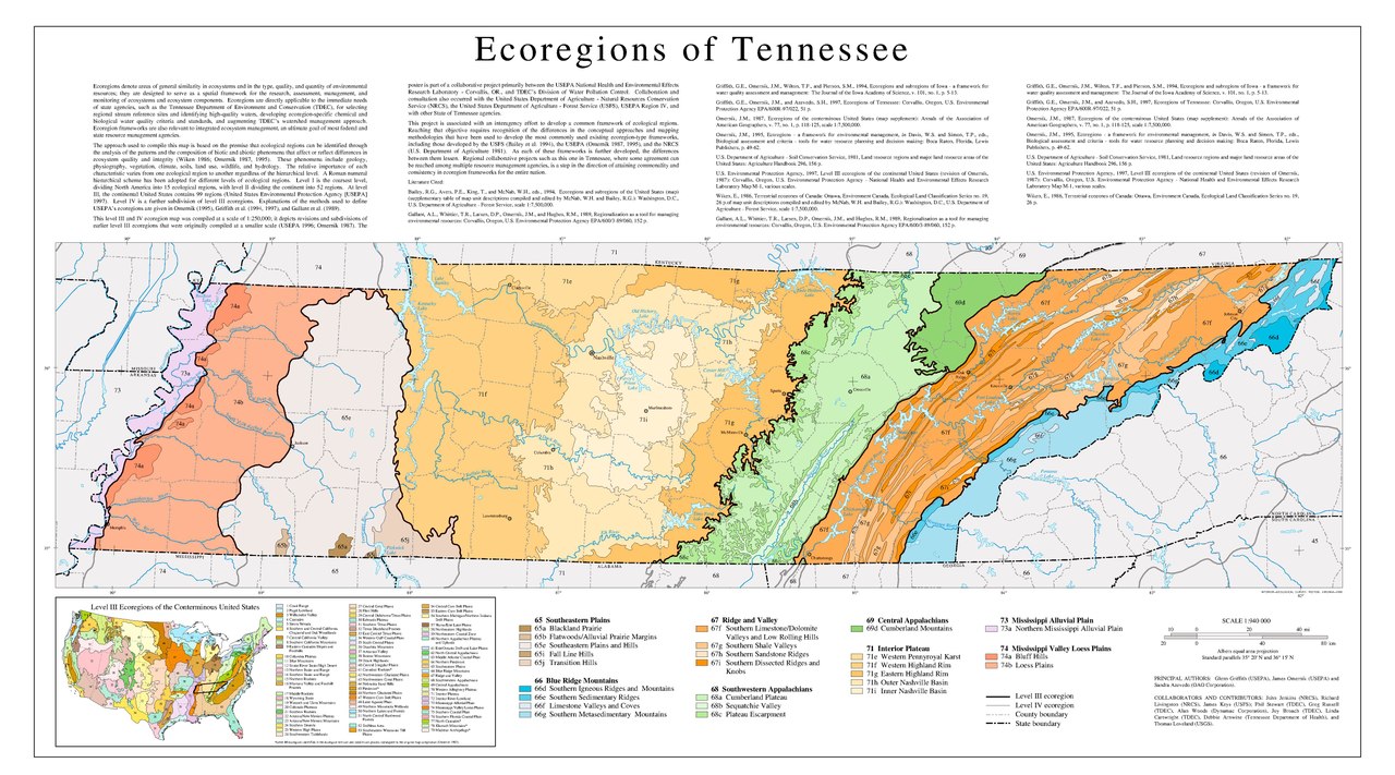
Map of Level IV ecoregions in the U.S. state of Tennessee, as defined by the United States Environmental Protection Agency.
|
|||||
| Date | ||||||
| Source | https://gaftp.epa.gov/EPADataCommons/ORD/Ecoregions/tn/tn_eco_lg.pdf | |||||
| Author | Glenn Griffith (USEPA), James Omernik (USEPA) and Sandra Azevedo (OAO Corporation) |
File history
Click on a date/time to view the file as it appeared at that time.
| Date/Time | Thumbnail | Dimensions | User | Comment | |
|---|---|---|---|---|---|
| current | 12:40, 4 June 2022 |  | 5,400 × 3,000 (1.65 MB) | TimK MSI (talk | contribs) | {{Information |Description= Map of Level IV ecoregions in the U.S. state of Tennessee, as defined by the United States Environmental Protection Agency. {{PD-USGov-EPA}} |Source=https://gaftp.epa.gov/EPADataCommons/ORD/Ecoregions/tn/tn_eco_lg.pdf |Date=2003 |Author=Glenn Griffith (USEPA), James Omernik (USEPA) and Sandra Azevedo (OAO Corporation) |Permission= |other_versions= }} Category:Maps of EPA ecoregions Category:Maps of Tennessee Category:Nature of Tennessee [[Category:Ecolo... |
You cannot overwrite this file.
File usage on Commons
There are no pages that use this file.