Category:Maps of the Cuban Missile Crisis
Jump to navigation
Jump to search
Media in category "Maps of the Cuban Missile Crisis"
The following 22 files are in this category, out of 22 total.
-
 1962 Cuba Missiles (30848755396).jpg 1,268 × 616; 394 KB
-
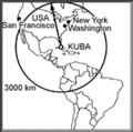 Amerikar.gif 322 × 320; 14 KB
-
 CubaMap1b w.jpg 593 × 512; 94 KB
-
 Cuban crisis map missile range.jpg 666 × 662; 198 KB
-
 CubaSites1962.jpg 760 × 627; 171 KB
-
 Estats Units - Crisi de Cuba (teatre american).png 568 × 510; 75 KB
-
 Fuerza de Tareas 137. 1962.jpg 953 × 960; 92 KB
-
-

-

-

-
 MRBM Field Launch Site San Cristobal No. 1 14 October 1962 - NARA - 193926.tif 3,000 × 2,532; 7.24 MB
-
 MRBM Field Launch Site San Cristobal No. 2 14 October 1962 - NARA - 193927.tif 3,000 × 2,524; 7.22 MB
-
 MRBM Launch Site 1 Sagua La Grande 1 November 1962 - NARA - 193932.tif 3,000 × 2,532; 7.24 MB
-
 MRBM Launch Site 1 San Cristobal, Cuba 25 October 1962 - NARA - 193928.tif 3,000 × 2,531; 7.24 MB
-
 MRBM Launch Site 1, 25 October 1962.jpg 760 × 623; 420 KB
-
 MRBM Launch Site 3 San Cristobal Cuba 27 January 1963 - NARA - 193935.tif 3,000 × 2,522; 7.22 MB
-
 MRBM Launch Site 3 San Cristobal, Cuba 27 October 1962 - NARA - 193931.tif 3,000 × 2,534; 7.25 MB
-
 Reconnaissance objectives in Cuba, 1962.JPG 1,800 × 1,292; 302 KB
-
 SA-2 Launch sites in Cuba.jpg 3,212 × 2,536; 2.99 MB
-
 Soviet Forces on Cuba (October 22, 1962).GIF 540 × 411; 16 KB
-
 The relative ranges of the IL-28, SS-4, and SS-5, stationed on Cuba.png 843 × 730; 182 KB
.jpg)


.png)


.jpg)


.GIF)
