Category:Maps of San Antonio, Texas
Jump to navigation
Jump to search
- 100 most populous cities of the United States
- 1–25
- Austin
- Boston
- Charlotte
- Chicago
- Columbus
- Dallas
- Denver
- El Paso
- Fort Worth
- Houston
- Indianapolis
- Jacksonville
- Los Angeles
- Nashville
- New York City
- Oklahoma City
- Philadelphia
- Phoenix
- Portland
- San Antonio
- San Diego
- San Francisco
- San Jose
- Seattle
- Washington, D.C.
- 26–50
- Arlington
- Atlanta
- Bakersfield
- Colorado Springs
- Detroit
- Fresno
- Kansas City
- Las Vegas
- Long Beach
- Louisville
- Memphis
- Miami
- Minneapolis
- Oakland
- Omaha
- Raleigh
- Sacramento
- Tucson
- Tulsa
- 51–75
- Anaheim
- Anchorage
- Cincinnati
- Cleveland
- Corpus Christi
- Durham
- Greensboro
- Honolulu
- Irvine
- Jersey City
- Lexington
- Lincoln
- Newark
- New Orleans
- Orlando
- Pittsburgh
- Plano
- Saint Paul
- Santa Ana
- St. Louis
- Tampa
- 76–100
- Boise
- Buffalo
- Chesapeake
- Chula Vista
- Fort Wayne
- Laredo
- Lubbock
- Madison
- Norfolk
- Richmond
- Santa Clarita
- Scottsdale
- St. Petersburg
- Spokane
- Toledo
- Winston-Salem
Wikimedia category | |||||
| Upload media | |||||
| Instance of | |||||
|---|---|---|---|---|---|
| Category combines topics | |||||
| San Antonio | |||||
city in Bexar County, Texas, United States      | |||||
| Instance of | |||||
| Named after | |||||
| Location | Bexar County, Texas | ||||
| Visitor center |
| ||||
| Head of government |
| ||||
| Inception |
| ||||
| Significant event |
| ||||
| Population |
| ||||
| Area |
| ||||
| Elevation above sea level |
| ||||
| Different from | |||||
| official website | |||||
 | |||||
Subcategories
This category has the following 2 subcategories, out of 2 total.
M
S
Media in category "Maps of San Antonio, Texas"
The following 49 files are in this category, out of 49 total.
-
 San Antonio Light Bird's Eye View Map of San Antonio, Texas December 1891 UTA.jpg 3,150 × 2,136; 3.32 MB
-

-

-

-

-

-

-
-

-

-

-
-

-

-

-

-
-

-

-
-

-

-

-

-

-

-
-
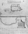 AlamoplanF0385.jpg 600 × 739; 111 KB
-
 Areacode830.svg 400 × 355; 2 MB
-

-
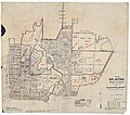
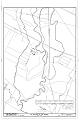
 Map of the city of San Antonio, Bexar County- including suburbs both north and south LOC 2010593158.jpg 10,282 × 15,555; 21.05 MB
-
 Map of the city of San Antonio, Bexar County- including suburbs both north and south LOC 2010593158.tif 10,282 × 15,555; 457.58 MB
-
 Map San Antonio.jpg 1,914 × 2,012; 928 KB
-
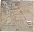
 Old map-San Antonio-1873.jpg 8,889 × 7,178; 15.55 MB
-
 Race and ethnicity 2010- San Antonio (5559903509).png 3,009 × 3,009; 3.55 MB
-
 Race and ethnicity San Antonio.png 3,009 × 3,009; 3.52 MB
-
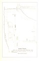
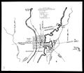
 Randolphafb-map.jpg 320 × 288; 12 KB
-
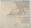
 Rullman's map of the city of San Antonio LOC 2009583814.jpg 12,818 × 14,324; 22.93 MB
-
 Rullman's map of the city of San Antonio LOC 2009583814.tif 12,818 × 14,324; 525.3 MB
-
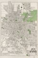
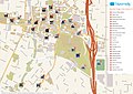 San Antonio printable tourist attractions map.jpg 2,105 × 1,488; 1.71 MB
-
 San Antonio satellite map (3).jpg 358 × 527; 215 KB
-
 San antonio satellite map.jpg 584 × 857; 360 KB
-
 San Antonio, Texas 1955 Yellow Book.jpg 800 × 824; 227 KB
-
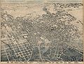 San Antonio, Texas in 1886.jpg 15,037 × 11,525; 69.58 MB
-
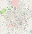
 San Antonio, TX.png 1,285 × 824; 502 KB
-
 Siege of Bexar.jpg 930 × 805; 76 KB
-
-
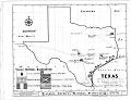
 TXMap-doton-SanAntonio.PNG 300 × 284; 15 KB
-
 Wurzbach map.svg 1,088 × 645; 426 KB

.jpg)
.jpg)
.jpg)
.jpg)
_-_Bexar_County_-_San_Antonio_-_ED_265-1_to_462_-_NARA_-_44271092_(page_1).jpg)
_-_Bexar_County_-_San_Antonio_-_ED_265-1_to_462_-_NARA_-_44271092_(page_2).jpg)
_-_Bexar_County_-_San_Antonio_-_ED_265-1_to_462_-_NARA_-_44271092_(page_3).jpg)
_-_Bexar_County_-_San_Antonio_-_ED_265-1_to_462_-_NARA_-_44271092_(page_4).jpg)
_-_Bexar_County_-_San_Antonio_-_ED_265-1_to_462_-_NARA_-_44271092_(page_5).jpg)
_-_Bexar_County_-_San_Antonio_-_ED_265-1_to_462_-_NARA_-_44271092_(page_6).jpg)
_-_Bexar_County_-_San_Antonio_-_ED_265-1_to_462_-_NARA_-_44271092_(page_7).jpg)
_-_Bexar_County_-_San_Antonio_Vicinity_-_ED_15-20,_15-32_to_40,_15-50_to_54,_15-53,_15-56_to_57,_15-59_to_73,_15-79_to_87,_15-91,_15-98_to_99,_15-101_-_NARA_-_44271100_(page_1).jpg)
_-_Bexar_County_-_San_Antonio_Vicinity_-_ED_15-20,_15-32_to_40,_15-50_to_54,_15-53,_15-56_to_57,_15-59_to_73,_15-79_to_87,_15-91,_15-98_to_99,_15-101_-_NARA_-_44271100_(page_2).jpg)
_-_Bexar_County_-_San_Antonio_Vicinity_-_ED_15-20,_15-32_to_40,_15-50_to_54,_15-53,_15-56_to_57,_15-59_to_73,_15-79_to_87,_15-91,_15-98_to_99,_15-101_-_NARA_-_44271100_(page_3).jpg)
_-_Bexar_County_-_San_Antonio_Vicinity_-_ED_15-20,_15-32_to_40,_15-50_to_54,_15-53,_15-56_to_57,_15-59_to_73,_15-79_to_87,_15-91,_15-98_to_99,_15-101_-_NARA_-_44271100_(page_4).jpg)
_-_Bexar_County_-_San_Antonio_Vicinity_-_ED_15-20,_15-32_to_40,_15-50_to_54,_15-53,_15-56_to_57,_15-59_to_73,_15-79_to_87,_15-91,_15-98_to_99,_15-101_-_NARA_-_44271100_(page_5).jpg)
_-_Bexar_County_-_San_Antonio_Vicinity_-_ED_15-20,_15-32_to_40,_15-50_to_54,_15-53,_15-56_to_57,_15-59_to_73,_15-79_to_87,_15-91,_15-98_to_99,_15-101_-_NARA_-_44271100_(page_6).jpg)
%27_(11207287404).jpg)
%27_(11207325135).jpg)
%27_(11202546243).jpg)
.png)
.png)
.png)


.jpg)


.png)


.jpg)


