Category:Maps of Ansbach
Jump to navigation
Jump to search
Urban districts (cities): Amberg · Ansbach · Aschaffenburg · Augsburg · Bamberg · Bayreuth · Coburg · Erlangen · Fürth · Hof · Ingolstadt · Kaufbeuren · Kempten · Landshut · Memmingen · Munich · Nuremberg · Passau · Regensburg · Rosenheim · Schweinfurt · Straubing · Weiden in der Oberpfalz · Würzburg
Deutsch: Karten und Pläne der Stadt Ansbach
Wikimedia category | |||||
| Upload media | |||||
| Instance of | |||||
|---|---|---|---|---|---|
| Category combines topics | |||||
| Ansbach | |||||
town in Bavaria, Germany   .svg) | |||||
| Pronunciation audio | |||||
| Instance of |
| ||||
| Part of |
| ||||
| Location | |||||
| Located in or next to body of water | |||||
| Street address |
| ||||
| Head of government |
| ||||
| Population |
| ||||
| Area |
| ||||
| Elevation above sea level |
| ||||
| Different from | |||||
| official website | |||||
 | |||||
Subcategories
This category has only the following subcategory.
A
Media in category "Maps of Ansbach"
The following 13 files are in this category, out of 13 total.
-
 Die fraenkischen Fuerstenthuemer.jpg 1,414 × 1,435; 827 KB
-
 AN (St) in Bayern.svg 1,227 × 1,236; 311 KB
-
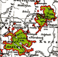
 Ansbach-Bayreuth 1792.png 1,180 × 825; 590 KB
-
 Ansbach-Bayreuth 1805.png 1,180 × 825; 498 KB
-
 Ansbach-Bayreuth.png 361 × 359; 44 KB
-
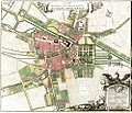 Ansbach.jpg 993 × 850; 188 KB
-
 Ansbach.png 188 × 235; 5 KB
-
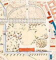 Hofgarten-1808-12.jpg 1,335 × 1,417; 222 KB
-
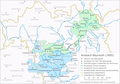
 Karte - Ansbach und Umgebung - um 1800.jpg 9,765 × 11,154; 4 MB
-
 Karte von Bayern Ansbach (Stadt).png 338 × 350; 35 KB
-
 Locator map AN (town) in Bavaria.svg 867 × 855; 1,000 KB
-
 Locator map AN (town) in Germany.svg 1,075 × 1,273; 581 KB
-
 Sprengstoffanschlag von Ansbach – Lageplan.jpg 928 × 672; 258 KB

_in_Bayern.svg)


.png)
_in_Bavaria.svg)
_in_Germany.svg)
