Category:Hand-Drawn Maps and Views of World War I Battlefields by H.M.
Jump to navigation
Jump to search
Media in category "Hand-Drawn Maps and Views of World War I Battlefields by H.M."
The following 33 files are in this category, out of 33 total.
-

-
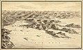
 Hand-drawn bird's eye view map of the Eastern Front of World War I.jpg 14,919 × 9,591; 36.62 MB
-
 Hand-drawn bird's eye view map of the Gulf of Venice in World War I.jpg 15,412 × 9,197; 26.84 MB
-
 Hand-drawn bird's eye view of the Gulf of Thessaloniki in World War I.jpg 19,376 × 11,773; 44.13 MB
-
 Hand-drawn bird's eye view of the Western Front of World War I between Arras and Soisson.jpg 11,915 × 16,823; 43.84 MB
-

-
 Hand-drawn bird's eye view of the Western Front of World War I near Pont-A-Mousson in Lorraine.jpg 15,407 × 10,977; 39.29 MB
-
 Hand-drawn bird's eye view of the Western Front of World War I near Suippes.jpg 20,317 × 12,933; 52.28 MB
-
 Hand-drawn bird's eye view of the Western Front of World War I north of Verdun.jpg 11,540 × 6,584; 19.73 MB
-
 Hand-drawn bird's eye view of the Western Front of World War I, showing Lille, Ypres and Ostende.jpg 12,770 × 8,147; 25.52 MB
-
 Hand-drawn map of Albania during World War I.jpg 3,787 × 8,377; 5.46 MB
-
 Hand-drawn map of Cernay and the Hartmannsweilerkopf Peak during World War I.jpg 3,862 × 5,671; 4.25 MB
-

-
 Hand-drawn map of Romania in World War I.jpg 6,913 × 8,478; 8.11 MB
-

-
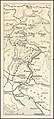
 Hand-drawn map of the Eastern Front of World War I in Latvia and Lithuania.jpg 5,517 × 8,836; 9.39 MB
-
 Hand-drawn map of the English Channel highlighting Schouwen-Duiveland during World War I.jpg 6,332 × 5,113; 4.67 MB
-
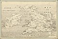
 Hand-drawn map of the Italian Front in World War I.jpg 11,670 × 8,757; 18.81 MB
-
 Hand-drawn map of the Italian Front of World War I north of Trieste.jpg 3,817 × 8,405; 4.98 MB
-
 Hand-drawn map of the Kamerun Campaign of World War I in West Africa.jpg 5,736 × 7,046; 6.12 MB
-
 Hand-drawn map of the Macedonian Front of World War I.jpg 7,732 × 7,590; 12.71 MB
-
 Hand-drawn map of the Romanian Campaign of World War I in 1916.jpg 10,817 × 10,756; 21.99 MB
-
 Hand-drawn map of the Siege of Kut-El-Amara in World War I in Iraq.jpg 7,223 × 5,095; 5 MB
-
 Hand-drawn map of the Somme Front of World War I between Theipval and Combles.jpg 9,407 × 6,797; 11.29 MB
-
 Hand-drawn map of the Western Front of World War I around Verdun.jpg 11,489 × 6,259; 14.27 MB
-
 Hand-drawn map of the Western Front of World War I at Verdun, between August 20th and 25th, 1917.jpg 13,151 × 7,276; 15.65 MB
-
 Hand-drawn map of the Western Front of World War I between Hebuterne and Courcelette.jpg 4,939 × 6,111; 5.15 MB
-
 Hand-drawn map of the Western Front of World War I between Lille and Peronne.jpg 6,943 × 13,398; 14.08 MB
-
 Hand-drawn map of the Western Front of World War I northeast of Soissons.jpg 10,984 × 6,424; 11.21 MB
-
 Hand-drawn map of the Western Front of World War I outside Bapaume.jpg 9,399 × 7,349; 10.56 MB
-
 Hand-drawn map of the Western Front of World War I outside Cambrai.jpg 9,392 × 10,349; 15.35 MB
-
 Hand-drawn map of the World War I Italian Front.jpg 9,097 × 8,305; 14.49 MB
-
 Hand-drawn view of the British Isles showing enemy attacks between 1915 and 1916 in World War I.jpg 10,987 × 7,365; 16.37 MB


