File:Topographic Map of the UK - hr.pdf
Jump to navigation
Jump to search

Size of this JPG preview of this PDF file: 414 × 599 pixels. Other resolutions: 166 × 240 pixels | 331 × 480 pixels | 530 × 768 pixels | 1,210 × 1,752 pixels.
Original file (1,210 × 1,752 pixels, file size: 4.17 MB, MIME type: application/pdf)
Captions
Captions
Add a one-line explanation of what this file represents
| Description |
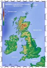
Hrvatski: Topografska karta Ujedinjenog Kraljevstva i Sjeverne Irske English: Topographic Map of the UK |
||
| Date | |||
| Source | Topographic Map of the UK - Blank.png | ||
| Author | |||
| PDF development |
|
I, the copyright holder of this work, hereby publish it under the following license:
This file is licensed under the Creative Commons Attribution 3.0 Unported license.
- You are free:
- to share – to copy, distribute and transmit the work
- to remix – to adapt the work
- Under the following conditions:
- attribution – You must give appropriate credit, provide a link to the license, and indicate if changes were made. You may do so in any reasonable manner, but not in any way that suggests the licensor endorses you or your use.
File history
Click on a date/time to view the file as it appeared at that time.
| Date/Time | Thumbnail | Dimensions | User | Comment | |
|---|---|---|---|---|---|
| current | 14:30, 20 April 2013 |  | 1,210 × 1,752 (4.17 MB) | MaGa (talk | contribs) | Title corrected |
| 18:51, 15 April 2013 |  | 1,193 × 1,735 (4.17 MB) | MaGa (talk | contribs) | {{Information |Description={{hr|Topografska karta Ujedinjenog Kraljevstva i Sjeverne Irske}}{{en|Topographic Map of the UK}} |Source=*Topographic Map of the UK - Blank.png |Date=2013-04-15 |Author=*[[:Fil... |
You cannot overwrite this file.
File usage on Commons
The following 4 pages use this file:
File usage on other wikis
The following other wikis use this file:
- Usage on hr.wikipedia.org