File:The "Farmer & Settler" map of Gallipoli War area - 1915.tif
Jump to navigation
Jump to search

Size of this JPG preview of this TIF file: 800 × 599 pixels. Other resolutions: 320 × 240 pixels | 640 × 479 pixels | 1,024 × 767 pixels | 1,280 × 958 pixels | 2,560 × 1,917 pixels | 11,792 × 8,829 pixels.
Original file (11,792 × 8,829 pixels, file size: 297.89 MB, MIME type: image/tiff)
Captions
Captions
The "Farmer & Settler" map of Gallipoli War area - 1915 / for The Farmers & Settlers' Newspaper Ltd., 437 Kent Street, Sydney ; J. H. Leonard
Summary[edit]
| Warning | The original file is very high-resolution. It might not load properly or could cause your browser to freeze when opened at full size. |
|---|
| Description |
English: The "Farmer & Settler" map of Gallipoli War area - 1915 / for The Farmers & Settlers' Newspaper Ltd., 437 Kent Street, Sydney ; J. H. Leonard |
|||||||||||||||||||||||
| Date | ||||||||||||||||||||||||
| Source |
|
|||||||||||||||||||||||
| Author | Sydney : printed by Marchant [& Co.], | |||||||||||||||||||||||

Licensing[edit]
|
This work is in the public domain in its country of origin and other countries and areas where the copyright term is the author's life plus 70 years or fewer. This work is in the public domain in the United States because it was published (or registered with the U.S. Copyright Office) before January 1, 1929. | |
| This file has been identified as being free of known restrictions under copyright law, including all related and neighboring rights. | |
File history
Click on a date/time to view the file as it appeared at that time.
| Date/Time | Thumbnail | Dimensions | User | Comment | |
|---|---|---|---|---|---|
| current | 11:11, 20 September 2019 | 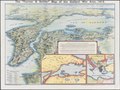 | 11,792 × 8,829 (297.89 MB) | Balkanique (talk | contribs) | User created page with UploadWizard |
You cannot overwrite this file.
File usage on Commons
There are no pages that use this file.