File:Sixth Map of Asia - 1478.tif
Jump to navigation
Jump to search

Size of this JPG preview of this TIF file: 800 × 594 pixels. Other resolutions: 320 × 238 pixels | 640 × 476 pixels | 1,024 × 761 pixels | 1,280 × 951 pixels | 1,378 × 1,024 pixels.
Original file (1,378 × 1,024 pixels, file size: 4.04 MB, MIME type: image/tiff)
Captions
Captions
Add a one-line explanation of what this file represents
Summary[edit]
| Description |
Latina: Sexta Asiae Tabula: Carmania altera[,] Arabia felix
English: Several editions of Ptolemy’s Geographia (Geography), translated into Latin from the original Greek, were published in Europe in the 15th century. This map is from the 1478 edition, which was published in Rome. Ptolemaic atlases included 12 maps of Asia. The “Sixth Map of Asia” covered the Arabian Peninsula. The outlines of this map are crude, but many geographic features, including the Red Sea, the Indian Ocean, and different features of the peninsula are clearly recognizable.
فارسی: از نسخههای نقشهٔ بطلمیوس، ترجمهشده به لاتین از نسخهٔ اصل یونانی. منتشرشده در سدهٔ ۱۵ میلادی در اروپا (رم). شامل شبه جزیرهٔ عربستان، خلیج فارس، دریای سرخ اقیانوس هند و دیگر سرزمینهای پیرامون.
العربية: إن العديد من طبعات جيوغرافيا (الجغرافيا) لبطليموس التي ترجمت من اليونانية الأصلية إلى اللاتينية، نُشرت في أوروبا في القرن الخامس عشر. وقد وردت هذه الخريطة في طبعة ١٤٧٨،التي نشرت في روما. وقد اشتملت أطالس بطليموس على ١٢خريطة لآسيا. واشتملت "خريطة آسيا السادسة" على شبه الجزيرة العربية. ورغم أن الخطوط العريضة لهذه الخريطة غير متقنة، فإن الكثير من المعالم الجغرافية، بما فيها البحر الأحمر، والمحيط الهندي، وملامح مختلفة من شبه الجزيرة يمكن التعرف عليها بوضوح.
Español: Varias ediciones de la Geographia (Geografía) de Ptolomeo, traducidas al latín del griego original, se publicaron en Europa en el siglo XV. Este mapa pertenece a la edición de 1478, que se publicó en Roma. Los atlas de Ptolomeo incluyen 12 mapas de Asia. El "Sexto mapa de Asia" abarcaba la Península Arábiga. Los contornos de este mapa son toscos, pero muchos de los accidentes geográficos, incluyendo el Mar Rojo, el océano Índico, y otros accidentes de la península son claramente reconocibles.
Français : Plusieurs éditions de l'œuvre de la Geographia (Géographie) de Ptolémée, traduites en latin à partir à partir de l'original grec, ont été publiées en Europe au XVe siècle. Cette carte provient de l'édition de 1478, publiée à Rome. Les atlas ptolémaïques comprennent 12 cartes de l'Asie. La "Sixième carte de l'Asie" couvrait la péninsule arabique. Les contours de cette carte sont rudimentaires, mais beaucoup d'éléments géographiques, dont la mer Rouge, l'océan Indien, et d'autres caractéristiques de la péninsule sont clairement reconnaissables.
Português: (Geografia), traduzida para o Latim do original Grego, foi publicado na Europa no século XV. Este mapa da edição 1478, a qual foi publicada em Roma. Os atlas ptolemaicos incluem 12 mapas da Ásia. O "Sexto Mapa da Ásia" cobre a Península Arábica. As linhas deste mapa são toscas, mas muitas características geográficas, incluindo o Mar Vermeho, o Oceano Índico, e diferentes características da península podem ser claramente reconhecidas.
Русский: ("География") Птолемея, переведенных на латинский язык с греческого оригинала, были опубликованы в Европе в XV веке. Данная карта — из издания 1478 года, опубликованного в Риме. Атласы Птолемея включают в себя 12 карт Азии. На "Шестой карте Азии" изображен весь Аравийский полуостров. Общие контуры на этой карте весьма схематичны, однако многие географические объекты, в том числе Красное море, Индийский океан и различные географические особенности полуострова четко узнаваемы.
中文(简体):几个版本的托勒密《地理学指南》(地理学),均从原希腊文翻译为拉丁文,并于 15 世纪在欧洲出版。 这幅地图是在罗马出版的 1478 年的版本。 托勒密地图册包括 12 幅亚洲地图。 "亚洲第六幅地图"涵盖了阿拉伯半岛。 地图的轮廓比较粗糙,但众多地理特征包括红海、印度洋以及半岛的不同特点均十分清晰。 |
||||||||||||||||||||||||||||||||||||||||||
| Date | |||||||||||||||||||||||||||||||||||||||||||
| Source |
|
||||||||||||||||||||||||||||||||||||||||||
| Author |
|
||||||||||||||||||||||||||||||||||||||||||
| Other versions |
|
||||||||||||||||||||||||||||||||||||||||||

.jpg)


Licensing[edit]
|
This work is in the public domain in its country of origin and other countries and areas where the copyright term is the author's life plus 100 years or fewer. | |
| This file has been identified as being free of known restrictions under copyright law, including all related and neighboring rights. | |
File history
Click on a date/time to view the file as it appeared at that time.
| Date/Time | Thumbnail | Dimensions | User | Comment | |
|---|---|---|---|---|---|
| current | 02:27, 5 September 2011 | 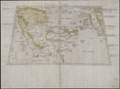 | 1,378 × 1,024 (4.04 MB) | ZxxZxxZ (talk | contribs) |
You cannot overwrite this file.
File usage on Commons
The following 6 pages use this file:
File usage on other wikis
The following other wikis use this file:
- Usage on arz.wikipedia.org
- Usage on de.wikipedia.org
- Usage on fa.wikipedia.org
- Usage on www.wikidata.org