File:Pyrenees-Atlantiques topographic map-fr.svg
Jump to navigation
Jump to search

Size of this PNG preview of this SVG file: 800 × 545 pixels. Other resolutions: 320 × 218 pixels | 640 × 436 pixels | 1,024 × 697 pixels | 1,280 × 871 pixels | 2,560 × 1,743 pixels | 2,350 × 1,600 pixels.
Original file (SVG file, nominally 2,350 × 1,600 pixels, file size: 2.61 MB)
Captions
Captions
Add a one-line explanation of what this file represents
Summary[edit]
| Camera location | | View this and other nearby images on: OpenStreetMap |
|---|
| Description |
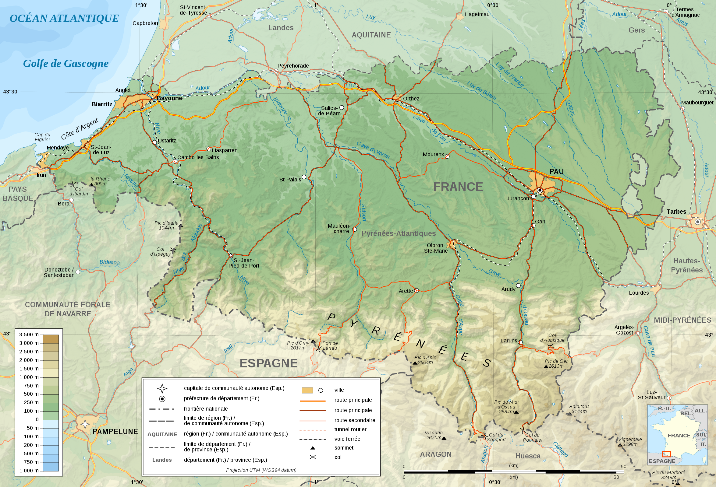
English: Topographic map in French of the department of the Pyrénées-Atlantiques Français : Carte topographique en français du département des Pyrénées-Atlantiques |
||
| Date | |||
| Source |
English: Own work ; Topographic data : NASA Shuttle Radar Topography Mission (SRTM3 v.2) (public domain) edited with 3DEM and dlgv32 Pro and vectorized with Inkscape ; UTM projection ; WGS84 datum ; shaded relief (composite image of N-W, W and N lightning positions) ; Bathymetry : USGov public domain data provided by Demis (see the approval e-mail and the Demis forum) ; References used for the additional data : * Géoportail France ; * ViaMichelin ; Approximate scales : * Topographic data : 1:400,000 (accuracy : about 100 m) ; * Bathymetry : 1:4 000 000 (accuracy : about 1,000 m) ; Note : The shaded relief is a raster image embedded in the SVG file. Français : Création personnelle ; Données topographiques de la NASA Shuttle Radar Topography Mission (SRTM3 v.2) (domaine public) éditées avec 3DEM et dlgv32 Pro et vectorisées avec Inkscape ; projection UTM ; WGS84 datum ; relief ombré (image composite d'éclairages du N-O, O et N) ; Bathymétrie : Données du gouvernement des ÉUA dans le domaine public fournies par Demis (voir le courriel d'approbation et le forum de Demis) ; Références utilisées pour les données complémentaires : * Géoportail France ; * ViaMichelin ; Échelles approximatives : * Données topographiques : 1:400 000 (précision : environ 100 m) : * Bathymétrie : 1:4 000 000 (précision : environ 1 000 m) ; Note : Le relief ombré est une image bitmap embarquée dans le fichier SVG. Approximate geographic limits of the map (15" close) : * SW corner : 42°41'N – 01°53'W * S-center latitude : 42°41'30"N * SE corner : 42°41'N – 00°07'E * NE corner : 43°41'N – 00°08'E * NW corner : 43°41'N – 01°54'W |
||
| Author | Eric Gaba (Sting - fr:Sting) | ||
| Permission (Reusing this file) |
|
||
| Other versions |
[]
|
||
| SVG development |


Licensing[edit]
I, the copyright holder of this work, hereby publish it under the following licenses:

|
Permission is granted to copy, distribute and/or modify this document under the terms of the GNU Free Documentation License, Version 1.2 or any later version published by the Free Software Foundation; with no Invariant Sections, no Front-Cover Texts, and no Back-Cover Texts. A copy of the license is included in the section entitled GNU Free Documentation License. |
This file is licensed under the Creative Commons Attribution-Share Alike 4.0 International, 3.0 Unported, 2.5 Generic, 2.0 Generic and 1.0 Generic license.
- You are free:
- to share – to copy, distribute and transmit the work
- to remix – to adapt the work
- Under the following conditions:
- attribution – You must give appropriate credit, provide a link to the license, and indicate if changes were made. You may do so in any reasonable manner, but not in any way that suggests the licensor endorses you or your use.
- share alike – If you remix, transform, or build upon the material, you must distribute your contributions under the same or compatible license as the original.
You may select the license of your choice.
File history
Click on a date/time to view the file as it appeared at that time.
| Date/Time | Thumbnail | Dimensions | User | Comment | |
|---|---|---|---|---|---|
| current | 07:54, 18 November 2016 | | 2,350 × 1,600 (2.61 MB) | Sémhur (talk | contribs) | Mise à jour : ajout de l'autoroute A65, ajout de la voie ferrée d'Oloron-Sainte-Marie à Bedous (ligne Pau-Canfranc), suppression de la voie ferrée de Buzy à Arudy. + Valid SVG |
| 02:03, 25 February 2013 |  | 2,350 × 1,600 (2.49 MB) | Ysangkok (talk | contribs) | scour | |
| 00:45, 23 September 2008 |  | 2,350 × 1,600 (3.27 MB) | Sting (talk | contribs) | Standardization of some colors and icons | |
| 12:37, 7 March 2008 |  | 2,350 × 1,600 (3.27 MB) | Sting (talk | contribs) | Detail | |
| 02:50, 7 March 2008 |  | 2,350 × 1,600 (3.26 MB) | Sting (talk | contribs) | Forgotten locator map | |
| 11:57, 5 March 2008 |  | 2,350 × 1,600 (3.19 MB) | Sting (talk | contribs) | Additional info | |
| 22:08, 4 March 2008 |  | 2,350 × 1,600 (3.26 MB) | Sting (talk | contribs) | Correction of a text rendering | |
| 21:53, 4 March 2008 |  | 2,350 × 1,600 (3.26 MB) | Sting (talk | contribs) | {{Location|43|12|00|N|00|50|00|W|scale:1000000}} <br/> {{Information |Description={{en|Topographic map in French of the department of the Pyrénées-Atlantiques}}{{fr|Carte topographique en français du département des [[:f |
You cannot overwrite this file.
File usage on Commons
The following 9 pages use this file:
- User:Jacopo Werther/Favourites/SVG
- User talk:Sting/Archive 01
- Commons:Quality images/Subject/Non photographic media
- Commons:Quality images candidates/Archives September 2008
- File:Pyrenees-Atlantiques administrative map-fr.jpg
- File:Pyrenees-Atlantiques topographic map-eu.png
- File:Pyrenees-Atlantiques topographic map-fr.jpg
- File:Pyrenees-Atlantiques topographic map-fr.svg
- Template:Other versions/Pyrenees-Atlantiques topographic map
File usage on other wikis
The following other wikis use this file:
- Usage on de.wikipedia.org
- Usage on el.wikipedia.org
- Usage on eo.wikipedia.org
- Usage on fr.wikipedia.org
- Usage on hy.wikipedia.org