File:Map of fertile cresent-sr.svg
Jump to navigation
Jump to search

Size of this PNG preview of this SVG file: 488 × 600 pixels. Other resolutions: 195 × 240 pixels | 391 × 480 pixels | 625 × 768 pixels | 833 × 1,024 pixels | 1,667 × 2,048 pixels | 1,987 × 2,441 pixels.
Original file (SVG file, nominally 1,987 × 2,441 pixels, file size: 467 KB)
Captions
Captions
Add a one-line explanation of what this file represents
| Description |
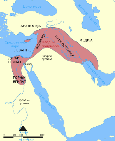
English: This map shows the location and extent of the Fertile Crescent, a region in the Middle East incorporating Ancient Egypt; the Levant; and Mesopotamia |
||
| Date | (UTC) | ||
| Source | Map of fertile cresent.svg | ||
| Author |
|
||
| SVG development | This map was created with Adobe Illustrator.
|
This file is licensed under the Creative Commons Attribution-Share Alike 3.0 Unported license.
- You are free:
- to share – to copy, distribute and transmit the work
- to remix – to adapt the work
- Under the following conditions:
- attribution – You must give appropriate credit, provide a link to the license, and indicate if changes were made. You may do so in any reasonable manner, but not in any way that suggests the licensor endorses you or your use.
- share alike – If you remix, transform, or build upon the material, you must distribute your contributions under the same or compatible license as the original.
Original upload log[edit]
This image is a derivative work of the following images:
- Map of fertile cresent.svg licensed with Cc-by-sa-3.0,2.5,2.0,1.0, GFDL
- 2011-05-22T11:06:47Z Nafsadh 1987x2441 (746245 Bytes) previous upload gurbled
- 2011-05-22T11:04:30Z Nafsadh 1987x2441 (746245 Bytes) Fonts enlarged
- 2011-05-22T10:53:48Z Nafsadh 1987x2441 (744760 Bytes) Fonts embedded
- 2011-05-22T10:45:20Z Nafsadh 1987x2441 (459645 Bytes) added region borders
- 2011-05-22T10:37:59Z Nafsadh 1987x2441 (186126 Bytes) {{Information |Description ={{en|1=This map shows the location and extent of the Fertile Crescent, a region in the Middle East incorporating Ancient Egypt; the Levant; and Mesopotamia}} |Source =Map_of_fertile_cres
Uploaded with derivativeFX
File history
Click on a date/time to view the file as it appeared at that time.
| Date/Time | Thumbnail | Dimensions | User | Comment | |
|---|---|---|---|---|---|
| current | 09:06, 14 September 2011 | | 1,987 × 2,441 (467 KB) | BokicaK (talk | contribs) | поцрнео нешто |
| 09:01, 14 September 2011 |  | 1,987 × 2,441 (467 KB) | BokicaK (talk | contribs) | flowed converted to text | |
| 02:40, 10 September 2011 |  | 1,987 × 2,441 (467 KB) | BokicaK (talk | contribs) | {{Information |Description={{en|1=This map shows the location and extent of the Fertile Crescent, a region in the Middle East incorporating Ancient Egypt; the Levant; and Mesopotamia}} |Source=*File:Map_of_fertile_cresent.svg |Date=2011-09-10 02:39 |
You cannot overwrite this file.
File usage on Commons
The following page uses this file:
File usage on other wikis
The following other wikis use this file:
- Usage on bs.wikipedia.org
- Usage on sh.wikipedia.org
- Usage on sr.wikipedia.org