File:Map of Sumner Co., Tennessee - from new and actual surveys LOC 2012593685.tif
Jump to navigation
Jump to search

Size of this JPG preview of this TIF file: 427 × 600 pixels. Other resolutions: 171 × 240 pixels | 342 × 480 pixels | 547 × 768 pixels | 729 × 1,024 pixels | 1,458 × 2,048 pixels | 11,295 × 15,868 pixels.
Original file (11,295 × 15,868 pixels, file size: 512.78 MB, MIME type: image/tiff)
Captions
Captions
Add a one-line explanation of what this file represents
Summary[edit]
| Warning | The original file is very high-resolution. It might not load properly or could cause your browser to freeze when opened at full size. |
|---|
| Description |
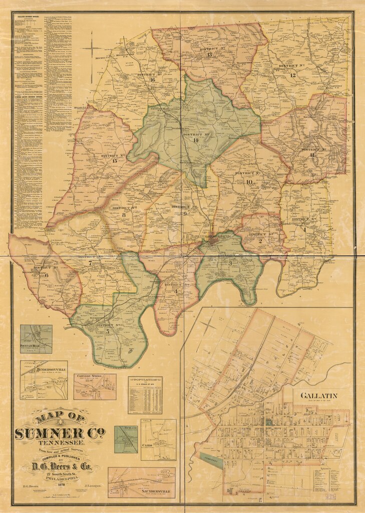
English: Cadastral map showing buildings, householders' names, warranty-deed tracts, warrantees' names, and tract acreages; the insets show real-property tracts (lots), owners' names, and building coverage. Hand col. to emphasize township/borough boundaries and areas. Relief shown by hachures. LC Land ownership maps, 880 Includes index to businesses, map of "Gallatin," and 1870 population census. Insets: Fountain Head -- Hendersonville -- Castalian Springs -- Richland -- Cairo -- Saundersville. Available also through the Library of Congress Web site as a raster image. Copy imperfect: Brittle, shellacked, hemmed at outer edges, and mounted on cloth. |
||
| Title | Map of Sumner Co., Tennessee : from new and actual surveys | ||
| Shelf ID | G3963.S9G46 1878 .B4 | ||
| Date | |||
| Source | https://www.loc.gov/item/2012593685/ | ||
| Author | Beers, D. G. (Daniel G.); Lanagan, J.; Bourquin, F. (Frederick); D.G. Beers & Co.; Worley & Bracher; Beers, D. G. | ||
| Permission (Reusing this file) |
|
||
| Other versions |
|
||
| Location | United States · Tennessee · Sumner County | ||
| Part of | American Memory · Catalog · County Landownership Maps · Geography And Map Division · Cultural Landscapes | ||
| Subject | Cadastral Maps · Maps · United States · Sumner County (Tenn.) · Tennessee · Sumner County · Real Property · Landowners |


Licensing[edit]
|
This is a faithful photographic reproduction of a two-dimensional, public domain work of art. The work of art itself is in the public domain for the following reason:
The official position taken by the Wikimedia Foundation is that "faithful reproductions of two-dimensional public domain works of art are public domain".
This photographic reproduction is therefore also considered to be in the public domain in the United States. In other jurisdictions, re-use of this content may be restricted; see Reuse of PD-Art photographs for details. | ||||
File history
Click on a date/time to view the file as it appeared at that time.
| Date/Time | Thumbnail | Dimensions | User | Comment | |
|---|---|---|---|---|---|
| current | 03:54, 5 June 2018 |  | 11,295 × 15,868 (512.78 MB) | Fæ (talk | contribs) | LOC Maps https://www.loc.gov/item/2012593685/ #20413 |
You cannot overwrite this file.
File usage on Commons
The following page uses this file: