File:Map Greece expansion 1832-1947 ja.svg
Jump to navigation
Jump to search

Size of this PNG preview of this SVG file: 457 × 599 pixels. Other resolutions: 183 × 240 pixels | 366 × 480 pixels | 586 × 768 pixels | 781 × 1,024 pixels | 1,563 × 2,048 pixels | 2,000 × 2,621 pixels.
Original file (SVG file, nominally 2,000 × 2,621 pixels, file size: 3.37 MB)
Captions
Captions
Add a one-line explanation of what this file represents
| Description |
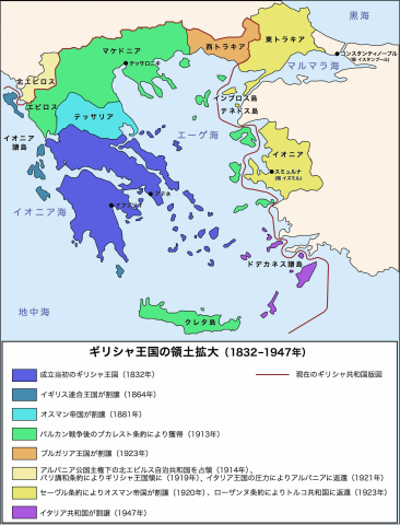
English: The territorial expansion of Greece, 1832-1947
日本語: ギリシャ王国の版図拡大 (1832-1947年) |
||||||||
| Date | |||||||||
| Source | File:Map Greece expansion 1832-1947-fr.svg | ||||||||
| Author | Original version created by Historicair, Japanese version created by 白拍子花子 | ||||||||
| Permission (Reusing this file) |
|
||||||||
| Other versions |
[]
|
||||||||
| SVG development |


.PNG)


.png)


File history
Click on a date/time to view the file as it appeared at that time.
| Date/Time | Thumbnail | Dimensions | User | Comment | |
|---|---|---|---|---|---|
| current | 17:38, 3 December 2010 | | 2,000 × 2,621 (3.37 MB) | 白拍子花子 (talk | contribs) | {{Information |Description= {{en|The territorial expansion of Greece, 1832-1947}} {{ja|ギリシャ王国の版図拡大 (1832-1947年)}} |Source=File:Map Greece expansion 1832-1947-fr.svg |Date=2010-12-03 |Author=Original version created by [[User:H |
You cannot overwrite this file.
File usage on Commons
There are no pages that use this file.