File:Lucky Peak Lake Recreation Areas.pdf
Jump to navigation
Jump to search

Size of this JPG preview of this PDF file: 800 × 518 pixels. Other resolutions: 320 × 207 pixels | 640 × 414 pixels | 1,024 × 663 pixels | 1,280 × 828 pixels | 2,550 × 1,650 pixels.
Original file (2,550 × 1,650 pixels, file size: 300 KB, MIME type: application/pdf)
Captions
Captions
Add a one-line explanation of what this file represents
Summary[edit]
| Description |
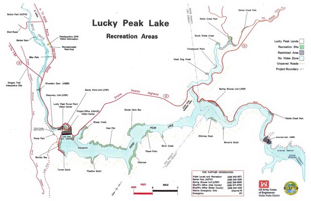
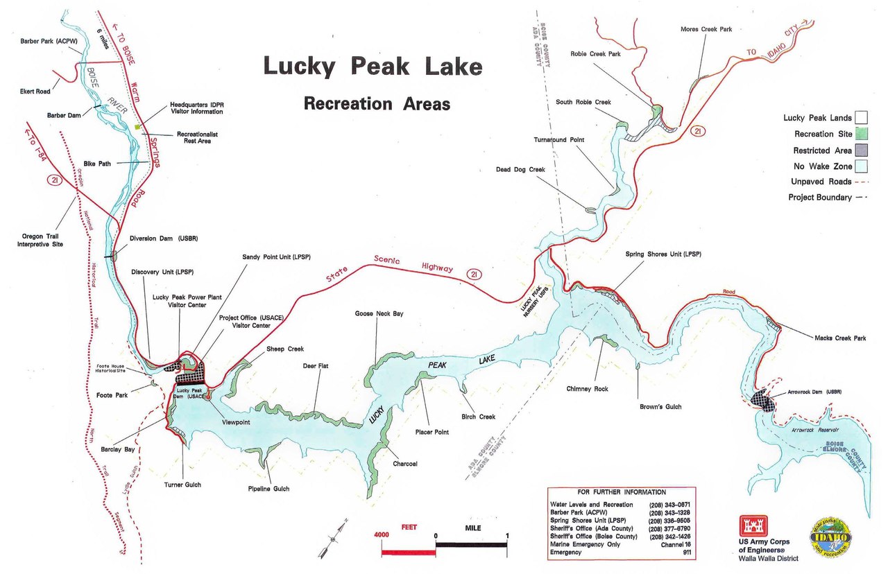
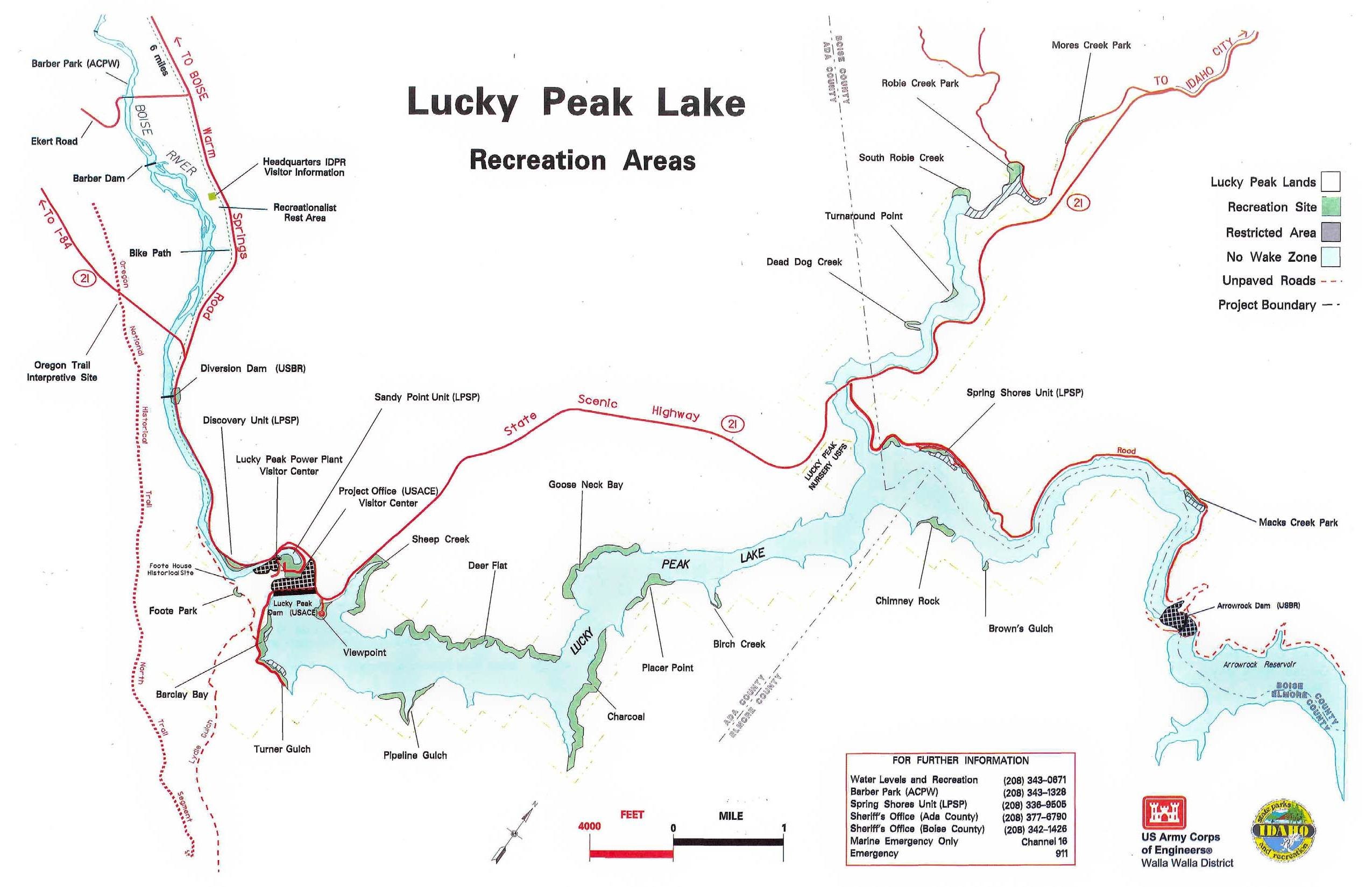
English: Map of Lucky Peak Lake Recreation Areas in Idaho by the US Army Corps of Engineers Walla Walla District published on 2014-04-09 |
| Date | |
| Source | https://www.nww.usace.army.mil/Portals/28/docs/recreation/LuckyPeak/TearOffMap.pdf |
| Creator |
US Army Corps of Engineers - Walla Walla District |
| Other versions | File:Lucky Peak Lake Recreation Areas.png |
Licensing[edit]
This work is in the public domain in the United States because it is a work prepared by an officer or employee of the United States Government as part of that person’s official duties under the terms of Title 17, Chapter 1, Section 105 of the US Code.
Note: This only applies to original works of the Federal Government and not to the work of any individual U.S. state, territory, commonwealth, county, municipality, or any other subdivision. This template also does not apply to postage stamp designs published by the United States Postal Service since 1978. (See § 313.6(C)(1) of Compendium of U.S. Copyright Office Practices). It also does not apply to certain US coins; see The US Mint Terms of Use.
|
 | |
| This file has been identified as being free of known restrictions under copyright law, including all related and neighboring rights. | ||
File history
Click on a date/time to view the file as it appeared at that time.
| Date/Time | Thumbnail | Dimensions | User | Comment | |
|---|---|---|---|---|---|
| current | 22:04, 9 January 2021 |  | 2,550 × 1,650 (300 KB) | Iketsi (talk | contribs) | Uploaded a work by US Army Corps of Engineers - Walla Walla District from https://www.nww.usace.army.mil/Portals/28/docs/recreation/LuckyPeak/TearOffMap.pdf with UploadWizard |
You cannot overwrite this file.
File usage on Commons
The following page uses this file: