File:Karte der alten Herrschaft Lohn.png
Original file (2,264 × 1,552 pixels, file size: 558 KB, MIME type: image/png)
Captions
Captions
Summary[edit]
| Description |
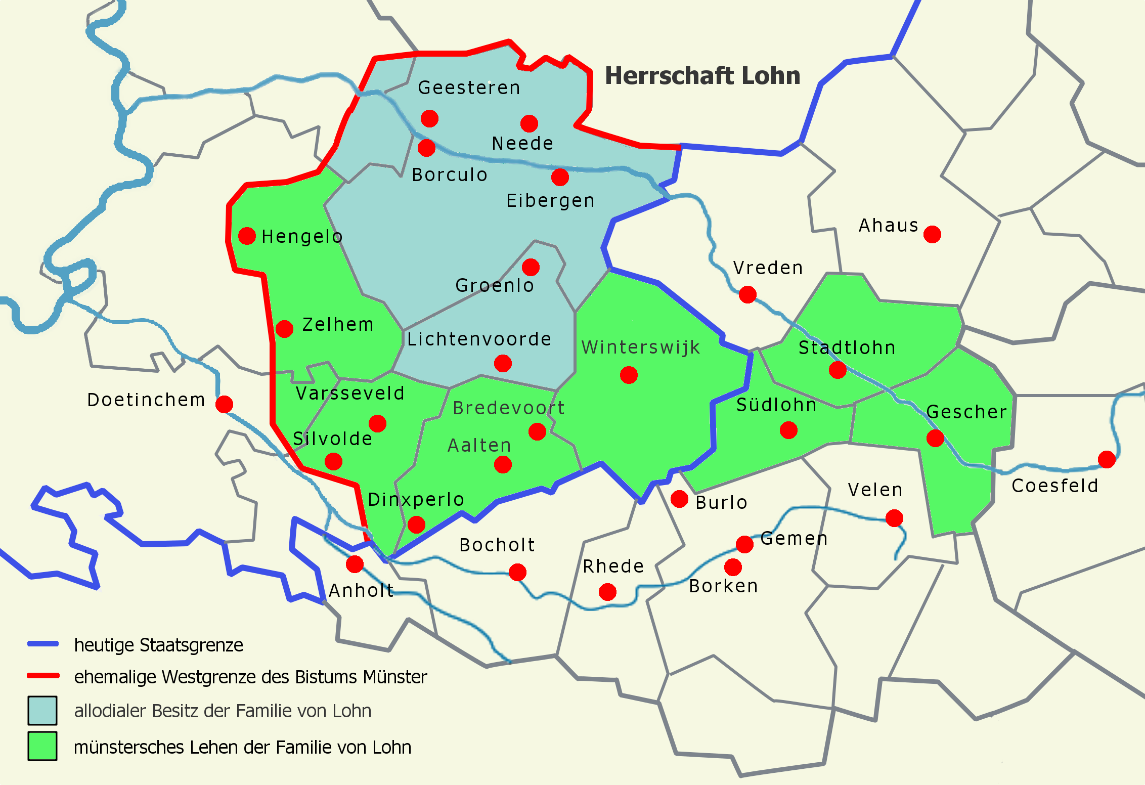
Deutsch: Karte mit der ungefähren Ausdehnung der historischen Herrschaft Lohn im Bereich des heutigen Westmünsterlandes und Achterhoeks um das Jahr 1250. Hier besaßen die Grafen von Lohn die vier Pfarreien Eibergen, Neede, Groenlo und Geesteren als Allodialbesitz. Vermutlich waren auch die Burg Borculo mit Teilen des Kirchspiels Geesteren, später Zentrum der Herrschaft Borculo, und die Herrlichkeit Lichtenvoorde Teil der Herrschaft Lohn. In den sechs Pfarreien Winterswijk (mit den Filialen Bredevoort, Aalten und Dinxperlo), Stadtlohn, Südlohn, Varsseveld (mit Silvolde), Zelhem und Hengelo (letztere beide bilden das sog. Land auf dem Goy) dagegen waren sie mit den Grafschaftsrechten lediglich durch den Bischof von Münster belehnt. Gleiches wird für das von Nordlohn abgepfarrte Gescher gegolten haben. Die Darstellung der Westgrenze der Diözese Münster basiert auf der Darstellung auf der letzten Seite von Germania Sacra NF 37.2. Die Südgrenze der Herrschaft folgt in seinen westlichen Teilen etwa der heutigen Staatsgrenze. |
| Date | |
| Source | Watzmann, own work |
| Author | Günter Seggebäing, Coesfeld |
Licensing[edit]
- You are free:
- to share – to copy, distribute and transmit the work
- to remix – to adapt the work
- Under the following conditions:
- attribution – You must give appropriate credit, provide a link to the license, and indicate if changes were made. You may do so in any reasonable manner, but not in any way that suggests the licensor endorses you or your use.
- share alike – If you remix, transform, or build upon the material, you must distribute your contributions under the same or compatible license as the original.
I have published this image (this file) as author under the Creative-Commons-License CC BY-SA 3.0 (“Attribution-ShareAlike 3.0”). Legally binding is only the full legalcode.
This means that free usage outside of Wikimedia projects is possible under the following terms of license:
- The image is credited with “© Günter Seggebäing, CC BY-SA 3.0” as part of the caption, of the image credits or of the edition notice. Provide a copy of, or the URI for, the applicable license (https://creativecommons.org/licenses/by-sa/3.0/legalcode).
- If this is not possible (due to shortage of space), contact me first.
- In online presences the author is mentioned, and weblinks to the original image and to the licence model are set: “© Günter Seggebäing, Wikimedia Commons, CC BY-SA 3.0”
Any of the above conditions can be waived if you get permission from the copyright holder.
This license and the rights granted hereunder will terminate automatically upon any breach by you of the terms of this license. In this case the author reserves to demand declaration to cease and desist, and compensation (according to the MFM fee references currently in force).
I would be happy to receive a specimen copy or the URL of the website where the image is used.
Please contact me (eMail via Wikipedia), if you
- need my postal address for sending a specimen copy or
- have further questions to the terms of license or
- like to have the picture in higher resolution or
- need another license model for usage.
⇒ More informations about reusing content from Wikimedia Commons.
|
The license of this work is not consistent with the licensing terms of Facebook. Therfore it is not permitted to use this work on Facebook |
File history
Click on a date/time to view the file as it appeared at that time.
| Date/Time | Thumbnail | Dimensions | User | Comment | |
|---|---|---|---|---|---|
| current | 20:15, 11 March 2016 | | 2,264 × 1,552 (558 KB) | Watzmann (talk | contribs) | == {{int:filedesc}} == {{Information |Description= {{de|1=Karte mit der ungefähren Ausdehnung der historischen Herrschaft Lohn im Bereich des heutigen Westmünsterlandes und [[:de:Achterhoek|Achterhoeks... |
You cannot overwrite this file.
File usage on Commons
There are no pages that use this file.
File usage on other wikis
The following other wikis use this file:
- Usage on de.wikipedia.org
- Usage on nl.wikipedia.org