Category:German-language maps showing history of Europe
Jump to navigation
Jump to search
Subcategories
This category has only the following subcategory.
Media in category "German-language maps showing history of Europe"
The following 200 files are in this category, out of 252 total.
(previous page) (next page)-
 01Europe blank map with Germany Region (detail).png 514 × 428; 35 KB
-
 01Europe blank map with Germany Region.png 1,360 × 1,245; 80 KB
-

-
-
 Mitteleuropa vor dem Beginn der Freiheitskriege 1813.jpg 2,048 × 1,705; 1.14 MB
-
 1834 Keller Pocket Map of Switzerland - Geographicus - Switzerland-keller-1834.jpg 5,000 × 4,239; 8.18 MB
-
 1850 Justus Perthes Map of Italy - Geographicus - Italy-perthes-50.jpg 4,000 × 3,334; 2.62 MB
-
 1850 Perthes Map of Bohemia ( Czech Republic ) - Geographicus - Boheme-perthes-1850.jpg 4,000 × 3,304; 3.58 MB
-
 1850 Perthes Map of France - Geographicus - France-perthes-1850.jpg 2,892 × 2,530; 2.07 MB
-
 (Spruner-Menke, map 14) The Iberian peninsula 531-711.jpg 3,355 × 2,759; 2.18 MB
-
 (Spruner-Menke, map 15) The Iberian peninsula 711-1028.jpg 3,359 × 2,763; 2.34 MB
-
 (Spruner-Menke, map 16) The Iberian peninsula 1086-1257.jpg 3,338 × 2,767; 2.32 MB
-
 (Spruner-Menke, map 17) The Iberian peninsula 1257-1492.jpg 3,368 × 2,813; 2.68 MB
-
 (Spruner-Menke, map 19) The Iberian peninsula at the start of the 16th century.jpg 3,363 × 2,776; 2.45 MB
-
 1905-03-ge-frankf-mapo.jpg 649 × 521; 69 KB
-
 20 europa 1849.jpg 9,850 × 7,575; 12.33 MB
-
 Abstimmungsergebnisse Ostpreußen 1920.JPG 2,197 × 1,389; 264 KB
-
 Alamannien Hochburgund ca 1000.png 2,500 × 2,107; 1.11 MB
-
 Angriff Bessarabien 02.png 436 × 332; 94 KB
-
 Ausbreitungroemischesreich.png 1,218 × 730; 256 KB
-
 Ausdehnung Bistum Basel korr.JPG 865 × 1,049; 120 KB
-
 Austria 1945-55.png 1,400 × 542; 60 KB
-
 Austria-Hungary (ethnic).jpg 4,314 × 2,820; 3.63 MB
-
 Austria-Hungary1899.JPG 3,340 × 2,520; 1.89 MB
-
 AntikeGriechen1.jpg 2,836 × 1,616; 1.96 MB
-
 Bessarabien und Dobrudscha.png 2,421 × 3,871; 1.79 MB
-
 Bessarabien und Moldawien.jpg 2,894 × 2,902; 2.48 MB
-
 Bezirk Bialystok.jpg 3,101 × 2,960; 9.8 MB
-
 Bezirk Lothringen.jpg 3,267 × 2,738; 2.13 MB
-
 Bezirk Ober-Elsaß (Karte).jpg 2,424 × 3,520; 1.64 MB
-
 Bezirk Unter-Elsaß (Karte).jpg 2,407 × 3,478; 1.98 MB
-
 Bistum Basel im 15. Jahrhundert.png 780 × 833; 83 KB
-
 Bistum Basel im 15. Jahrhundert0105a.png 780 × 833; 102 KB
-
 Bistum-Basel2.png 2,500 × 1,956; 898 KB
-
 Bourbonnais 12. Jh.png 557 × 494; 141 KB
-
 Bukarest 1900.JPG 2,409 × 1,779; 5.17 MB
-
 Bulgaria (ethnic) 1892.JPG 4,175 × 3,430; 1.7 MB
-
 Bulgarians in 1912.jpg 2,696 × 1,964; 2.05 MB
-
 Burggrafschaft Friedberg.png 1,387 × 660; 269 KB
-
 Burgund 12. Jh.png 1,792 × 1,471; 1,006 KB
-
 CarlSaxET1877.jpg 3,100 × 2,968; 7.57 MB
-
 Carte de la végétation de l'Europe.png 660 × 605; 773 KB
-
 Central Europe (economy).jpg 2,306 × 1,450; 3.28 MB
-
 Central Europe (ethnic).JPG 2,230 × 1,436; 2.81 MB
-
 Ceskoslovensko37.jpg 3,115 × 1,563; 1.02 MB
-
 Charte vom Niedersächsischen Kreise, 1804.jpg 3,226 × 2,939; 9.12 MB
-
 Constantinople map German.png 995 × 1,279; 163 KB
-
 Danube mouths 1867.JPG 4,064 × 3,088; 3.7 MB
-
 Das Grossdeutsche Reich.jpeg 1,500 × 1,584; 713 KB
-
 Das roemische Wien.png 971 × 803; 532 KB
-
 Der westfälische Hellweg.jpg 3,287 × 1,142; 1.11 MB
-
 Deutsch-Niederländischer Sprachraum (nach Werner König).png 2,912 × 2,232; 1.39 MB
-
 Deutsche Dialekte 1910.png 7,107 × 4,683; 13.39 MB
-
 Deutsche Rechts- und Gerichtskarte (1895).jpg 6,550 × 5,100; 6.56 MB
-
 Deutscher Orden 1260+Farb.png 1,200 × 1,043; 436 KB
-
 Deutscher Orden 1260.png 1,200 × 1,043; 857 KB
-
 Deutscher Orden 1410+Farb.png 1,200 × 1,043; 370 KB
-
 Deutscher Orden 1410.png 1,200 × 1,043; 868 KB
-
 Deutscher Orden 1466+Farb.png 1,200 × 1,043; 321 KB
-
 Deutscher Orden 1466.png 1,200 × 1,043; 742 KB
-
 Deutscher Orden in Europa 1300.png 2,500 × 1,897; 522 KB
-
 Deutsches Reich Konfessionskarte.jpg 2,400 × 1,942; 1.68 MB
-
 Die Illyrischen Stamme (German).png 643 × 800; 200 KB
-
 Die Völker und Reiche der Slaven zwichen Elbe und Don bis 1125 - Chrobacia.jpg 1,296 × 1,320; 703 KB
-
 Die Völker und Reiche der Slaven zwichen Elbe und Don bis 1125.jpg 5,008 × 3,498; 12.21 MB
-
 Map of Dobrudja, 1878-1879.jpg 1,609 × 1,518; 849 KB
-
 Droysens-24.jpg 8,925 × 5,837; 4.68 MB
-
 Elsass-Lothringen 1905.png 1,457 × 2,000; 1.97 MB
-
 England Grosses Heer 865.png 848 × 868; 711 KB
-
 Ethnic map (1914).jpg 1,396 × 998; 562 KB
-
 Ethnic map East Prussia 1907.jpeg 1,682 × 2,139; 4.75 MB
-
 Ethnische Karte Bessarabiens 1930.png 1,335 × 1,423; 416 KB
-
 Ethnographic map of Epirus, based on P. Aravandinos, 1878.jpg 2,696 × 3,101; 2.55 MB
-
 Europa 1400.jpg 3,054 × 2,436; 2.01 MB
-
 Europa 1477.JPG 3,036 × 2,418; 2.08 MB
-
 Europa 1519.JPG 3,042 × 2,424; 1.93 MB
-
 Europa1899.JPG 3,111 × 2,574; 2.01 MB
-
 EuropaNATOWP1959.png 1,165 × 1,200; 353 KB
-
 Europe 1812 map de.png 2,284 × 1,503; 1.13 MB
-
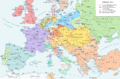 Europe 1815 map de.png 2,284 × 1,503; 1.07 MB
-
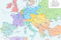
 Europe 1848 map de.png 2,284 × 1,503; 1.22 MB
-
 Europe 1867 map de.png 2,284 × 1,503; 1.07 MB
-
 Europe 1871 map de.png 2,284 × 1,503; 1.03 MB
-
 Europe 1878 map de.png 2,284 × 1,503; 1.01 MB
-
 Franken Expansion bis 6Jhdt.png 2,102 × 1,674; 856 KB
-
 Frankreich 12. Jh (ohne Süd).png 2,607 × 2,640; 2.41 MB
-
 Frankreich 12. Jh 2021-08-03.png 2,607 × 2,640; 2.47 MB
-
 Frankreich1860Bahnstrecken.png 783 × 800; 32 KB
-
 Freiburg in Brockhaus 1937.jpg 1,579 × 2,672; 2.44 MB
-
 Friedrich List und die erste grosse Eisenbahn 2.jpg 1,683 × 2,064; 422 KB
-
 Fuerstbistum Basel 16Jh.png 1,500 × 1,174; 237 KB
-
 Fürstentümer Nitra und Mähren.png 492 × 582; 18 KB
-
 Historische Karte von Gansheim.jpg 465 × 399; 64 KB
-
 General.governement.map.1943.jpg 690 × 709; 771 KB
-
 Generalgouvernement.png 2,092 × 2,505; 2.71 MB
-
 Geological map germany 1869 equirect.png 1,823 × 2,132; 7.22 MB
-
 Brockhaus 1894 Deutsche Mundarten Sorbisch.jpg 900 × 675; 464 KB
-
 Germania Magna nach Ptolemaeus.jpg 666 × 748; 178 KB
-
 Germanische und slavische Volksstaemme zwischen Elbe und Weichsel.jpg 1,973 × 1,665; 1.03 MB
-
 Germany962.jpg 618 × 770; 172 KB
-
 Gliederung Stadtstaat Basel 1798.png 1,500 × 1,266; 285 KB
-
 Grafik - Lagebesprechung Wolfsschanze, 20. Juli 1944.png 721 × 750; 99 KB
-
-
 Grafschaft Mark 1791 Friedrich C Mueller.jpg 2,033 × 1,800; 1.32 MB
-
 Great Moravia-deu.png 1,323 × 1,122; 533 KB
-
 Greater German Reich NS Administration 1944 Variant.png 2,616 × 2,031; 531 KB
-
 Greater German Reich NS Administration 1944.png 2,607 × 2,021; 547 KB
-
 Greece ethnic 1897.JPG 2,268 × 2,358; 901 KB
-
 Greek history.png 868 × 624; 29 KB
-
 Greek-Colonisation-of-Sicily-bjs-1.jpg 1,099 × 733; 252 KB
-
 Griechische Gegenoffensive.png 300 × 500; 50 KB
-
 Griechische-Offensive-3.png 330 × 355; 19 KB
-
 Grossdeutsches Reich NS Administration 1944.png 2,615 × 2,030; 250 KB
-
 Grossdeutsches Reich Staatliche Administration 1944.png 2,606 × 2,023; 270 KB
-
 Grossfuerstentum Siebenbuergen 1857.JPG 2,312 × 3,100; 2.5 MB
-
 Güssefeld, Karte der Braunschweigischen Lande, 1786.jpg 2,924 × 2,316; 4.72 MB
-
 Hansesprache-mit Legende.jpg 6,750 × 4,000; 8.38 MB
-
 Hansesprache.jpg 6,750 × 4,000; 9.61 MB
-
 Heinrich Berghaus. Europe, Ethnographic, 1855.jpg 851 × 649; 134 KB
-
 Hilfe gmt beispiel italien.png 1,062 × 1,140; 42 KB
-
 Historische Karte CH Rom 1.png 2,500 × 1,588; 1.22 MB
-
 Historische Regionen Europas.png 800 × 525; 180 KB
-
 Humoristische Karte von Europa im Jahre 1870.jpg 1,965 × 1,495; 1.25 MB
-
 Hungary (population in 1880).JPG 6,090 × 4,676; 5.27 MB
-
 Hungary, Galicia and Transylvania.jpg 3,000 × 2,354; 2.48 MB
-
 Hungary-ethnic groups.jpg 2,913 × 2,250; 2.18 MB
-
 Imperium Germaniae.jpg 8,926 × 4,439; 5.41 MB
-
 Iraq war opponents.PNG 1,360 × 1,245; 122 KB
-
 Istria (ethnic)-Czörnig.png 515 × 668; 932 KB
-
 Istria (ethnic).JPG 877 × 1,391; 1,010 KB
-
 Italien 1843–1870.png 924 × 953; 215 KB
-
 Johanniterorden in Europa 1300.png 2,500 × 1,899; 574 KB
-
 Juden 1881.JPG 4,782 × 3,936; 3.96 MB
-
 KaisertumOsterreich.png 800 × 593; 213 KB
-
 Kanton Basel-Stadt 1836.jpg 2,914 × 2,211; 2.98 MB
-
 Karte - Britisch-Kanadischer Vormarsch, April 1945.png 1,164 × 577; 214 KB
-
 Karte - Bündnissysteme in Europa 1725-1730.png 3,872 × 2,761; 1,009 KB
-
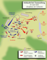 Karte - Schlacht bei Tannenberg 1410, Ende.png 1,003 × 1,279; 376 KB
-
 Karte - Schlacht bei Tannenberg 1410, Eröffnung.png 1,003 × 1,279; 434 KB
-
 Karte aus dem Buch Römische Provinzen von Theodor Mommsen 1921 07.jpg 2,310 × 2,169; 6.01 MB
-
 Karte der alten Herrschaft Lohn.png 2,264 × 1,552; 558 KB
-
 Karte Deutsch-Dänischer Krieg Militärereignisse.png 1,861 × 2,228; 708 KB
-
 Karte Elsass-Lothringens 1905.jpg 2,695 × 3,821; 3.8 MB
-
 Karte Mährerreich Mojmír I.png 1,126 × 994; 1.14 MB
-
 Karte Mährerreich Rastislav.png 1,126 × 994; 1.14 MB
-
 Karte Mährerreich Svatopluk I.png 1,126 × 994; 1.22 MB
-
 Karte Schwabenkrieg.png 1,990 × 1,052; 346 KB
-
 Karte Schwarzburger Fürstentümer.jpg 445 × 395; 127 KB
-
 Karte Slowakischer Nationalaufstand 1944 - Schlussoffensive.png 2,013 × 1,107; 2.03 MB
-
 Karte westwall.png 800 × 1,391; 161 KB
-
 Kelten Austria.png 2,324 × 1,495; 418 KB
-
 Kimbern Teutonen Wanderung.png 806 × 523; 39 KB
-
 Kimbernkriege, Karte 1.png 896 × 554; 986 KB
-
 Kimbernkriege, Karte 2.png 896 × 554; 980 KB
-
 Kirchenprovinzen Deutschland 1500.jpg 1,116 × 900; 529 KB
-
 Konzentrazionslager auschwitz map.png 1,205 × 1,047; 234 KB
-
 Konzept eines Süddeutschen Pufferstaates (1941).png 1,195 × 758; 333 KB
-
 Krain SCHPRACHEN-KARTE 1880 Pict 1.JPG 763 × 632; 250 KB
-
 Kriegsschauplatz Ostsee.jpg 2,252 × 2,806; 401 KB
-
 Kriegsziele im Westen.jpg 3,090 × 1,958; 1.23 MB
-
 Krondomäne 12. Jh.png 1,054 × 1,017; 481 KB
-
 Księstwo Cieszyńskie (Herzogtum Teschen) - mapa niem. (1893).jpg 472 × 508; 59 KB
-
 Lateinisches Kaisereich.png 3,404 × 2,035; 1.03 MB
-
 Luthmer V - 257 - Karte.jpg 2,986 × 3,443; 3.01 MB
-
 Lutizenbund.PNG 713 × 616; 122 KB
-
 Lutizenbund1.png 713 × 616; 156 KB
-
 Main ethnic groups in Europe (1899).JPG 1,152 × 1,166; 323 KB
-
 Map Greece expansion 1832-1947-de.png 990 × 836; 181 KB
-
 Map of Curonian Spit.jpg 377 × 537; 29 KB
-
 Map of europe in 385 BC.jpg 1,273 × 894; 526 KB
-
 Map of Spain 1490.jpg 1,637 × 1,504; 224 KB
-
 MarkChamNabburg.jpg 564 × 694; 332 KB
-
 Mediterranean at 218 BC-de.png 2,858 × 1,696; 453 KB
-
 Minoan Ash.png 580 × 500; 423 KB
-
 Mitteleuropa (ethnische Karte) 1932.jpg 1,571 × 1,446; 383 KB
-
 Mitteleuropa – Völker und Sprachgebiete 1904.jpg 5,625 × 4,153; 16.82 MB
-
 Mitteleuropa-Konfessionen 1901.JPG 2,895 × 2,181; 1.73 MB
-
 Moldova 1917.JPG 3,762 × 4,926; 3.03 MB
-
 Das Mongolenreich unter den Erben Dschingis Khans.GIF 752 × 591; 135 KB
-
 NordgauMarkNabburgMarkCham.jpg 412 × 650; 181 KB
-
 Norwegen Wikingerzeit.JPG 575 × 750; 83 KB
-
 NS administrative Gliederung 1944.png 8,000 × 6,094; 4.14 MB
-
 OldHighGermanlanguagearea962.png 1,114 × 1,585; 2.04 MB
-
 Operation Wunderland.png 1,772 × 1,772; 677 KB
-
 Ordensstaat-kirchlich.jpg 539 × 539; 78 KB
-
 Ostseegliederung.png 871 × 1,039; 80 KB
-
 Paläografische Evolution des Donaudeltas.png 876 × 990; 1.03 MB
-
 Pelopones ethnic.JPG 2,334 × 1,918; 929 KB
-
 Peloponnese relief map2de.png 2,000 × 1,566; 1.15 MB
-
 Perserkriege Mykale.jpg 1,800 × 1,091; 353 KB
-
 Perserkriege.jpg 1,800 × 1,091; 774 KB
-
 Pestilence spreading 1347-1351 europe.png 1,280 × 1,387; 350 KB
-
 Petroleum in Rumania (1900).JPG 2,660 × 3,496; 2.11 MB
-
 Polen1020.png 700 × 691; 483 KB
-
 Polen960.png 520 × 513; 270 KB
-

-
 Provinz Pommern.jpg 11,163 × 8,713; 18.22 MB
-
 Regierunsgbezirk Eger 1938–1945.png 1,198 × 1,372; 93 KB
-
 Reichsgau Danzig Westpreussen.jpg 2,097 × 2,512; 511 KB
-
 Reichskommissariat Ostland.png 442 × 448; 41 KB
_-_Geographicus_-_Franconiae-homann-1720.jpg)
_-_Geographicus_-_SaxoniaeInferioris-homann-1730.jpg)


_-_Geographicus_-_Boheme-perthes-1850.jpg)

_The_Iberian_peninsula_531-711.jpg)
_The_Iberian_peninsula_711-1028.jpg)
_The_Iberian_peninsula_1086-1257.jpg)
_The_Iberian_peninsula_1257-1492.jpg)
_The_Iberian_peninsula_at_the_start_of_the_16th_century.jpg)


.jpg)


.jpg)
.jpg)


_1892.JPG)


.jpg)
.JPG)


.png)

.jpg)


.png)


.jpg)


.png)


.JPG)


-Cz%C3%B6rnig.png)
.JPG)


.png)


_-_mapa_niem._(1893).jpg)


.JPG)


_1932.jpg)


.JPG)


.png)