File:Egypt and Syria 1768 to 1774 map de.png
Jump to navigation
Jump to search

Size of this preview: 771 × 600 pixels. Other resolutions: 309 × 240 pixels | 617 × 480 pixels | 987 × 768 pixels | 1,280 × 996 pixels | 2,560 × 1,992 pixels | 2,792 × 2,172 pixels.
Original file (2,792 × 2,172 pixels, file size: 874 KB, MIME type: image/png)
Captions
Captions
Add a one-line explanation of what this file represents
Summary[edit]
| Description |
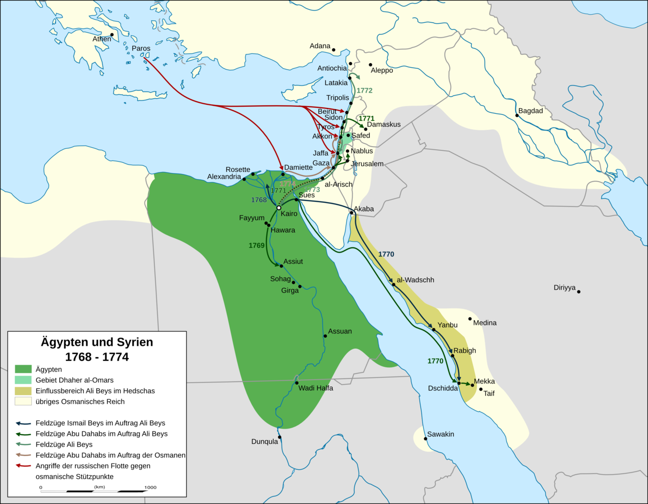
English: map of mamluk egypt, palestine and syria 1768 to 1774. campaigns and advances according to Sauveur Lusignan: A history of the Revolution of Ali Bey against the Ottoman Porte (London 1783) and Meyers Konversationslexikon, vol. 1, page 359 (Leipzig, 4th edition, 1885-1892)
Deutsch: Karte der Feldzüge in Ägypten, Palästina und Syrien 1768 bis 1774 |
| Date | |
| Source | Own work, derivat of File:Africa location map.svg |
| Author | Don-kun, Eric Gaba (Sting - fr:Sting) |
| Other versions |
 |
Licensing[edit]
I, the copyright holder of this work, hereby publish it under the following licenses:

|
Permission is granted to copy, distribute and/or modify this document under the terms of the GNU Free Documentation License, Version 1.2 or any later version published by the Free Software Foundation; with no Invariant Sections, no Front-Cover Texts, and no Back-Cover Texts. A copy of the license is included in the section entitled GNU Free Documentation License. |
This file is licensed under the Creative Commons Attribution 3.0 Unported license.
- You are free:
- to share – to copy, distribute and transmit the work
- to remix – to adapt the work
- Under the following conditions:
- attribution – You must give appropriate credit, provide a link to the license, and indicate if changes were made. You may do so in any reasonable manner, but not in any way that suggests the licensor endorses you or your use.
You may select the license of your choice.
File history
Click on a date/time to view the file as it appeared at that time.
| Date/Time | Thumbnail | Dimensions | User | Comment | |
|---|---|---|---|---|---|
| current | 17:04, 26 April 2015 | | 2,792 × 2,172 (874 KB) | Don-kun (talk | contribs) | corrections in Hedschas and south egypt according discussion. |
| 21:04, 31 December 2014 |  | 2,792 × 2,172 (866 KB) | Don-kun (talk | contribs) | some corrections | |
| 18:40, 12 December 2014 |  | 2,792 × 2,172 (571 KB) | Kopiersperre (talk | contribs) | optipng | |
| 19:25, 8 December 2014 |  | 2,792 × 2,172 (826 KB) | Don-kun (talk | contribs) | geändert entsprechend Diskussion Kartenwerkstatt | |
| 16:44, 31 October 2014 |  | 3,066 × 2,543 (963 KB) | Don-kun (talk | contribs) | {{Information |Description ={{en|1=map of mamluk egypt, palestine and syria 1768 to 1774}} {{de|1=Karte der Feldzüge in Ägypten, Palästina und Syrien 1768 bis 1774}} |Source ={{own}}, derivat of File:Africa location map.svg |Author... |
You cannot overwrite this file.
File usage on Commons
There are no pages that use this file.
File usage on other wikis
The following other wikis use this file:
- Usage on arz.wikipedia.org
- Usage on azb.wikipedia.org
- Usage on bn.wikipedia.org
- Usage on de.wikipedia.org
- Usage on en.wikipedia.org
- Usage on es.wikipedia.org
- Usage on fi.wikipedia.org
- Usage on id.wikipedia.org
- Usage on ru.wikipedia.org
- Usage on sl.wikipedia.org
- Usage on uk.wikipedia.org