File:CatoctinFormationMap2.pdf
Jump to navigation
Jump to search

Size of this JPG preview of this PDF file: 633 × 600 pixels. Other resolutions: 253 × 240 pixels | 507 × 480 pixels | 811 × 768 pixels | 1,275 × 1,208 pixels.
Original file (1,275 × 1,208 pixels, file size: 406 KB, MIME type: application/pdf)
Captions
Captions
Catoctin Formation Map
Summary[edit]
| Description |
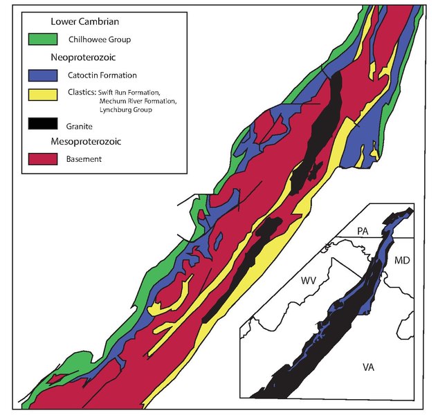
English: Geological Map of the Catoctin Formation and other formations associated with it. |
| Date | |
| Source | Own work |
| Author | Mannepuckett |
Licensing[edit]
I, the copyright holder of this work, hereby publish it under the following license:
This file is licensed under the Creative Commons Attribution-Share Alike 4.0 International license.
- You are free:
- to share – to copy, distribute and transmit the work
- to remix – to adapt the work
- Under the following conditions:
- attribution – You must give appropriate credit, provide a link to the license, and indicate if changes were made. You may do so in any reasonable manner, but not in any way that suggests the licensor endorses you or your use.
- share alike – If you remix, transform, or build upon the material, you must distribute your contributions under the same or compatible license as the original.
File history
Click on a date/time to view the file as it appeared at that time.
| Date/Time | Thumbnail | Dimensions | User | Comment | |
|---|---|---|---|---|---|
| current | 02:30, 13 April 2021 |  | 1,275 × 1,208 (406 KB) | Mannepuckett (talk | contribs) | Uploaded own work with UploadWizard |
You cannot overwrite this file.
File usage on Commons
There are no pages that use this file.
File usage on other wikis
The following other wikis use this file:
- Usage on en.wikipedia.org
Metadata
Categories:
- Geological maps of the United States
- Maps of the Catoctin Formation
- Chilhowee Group
- Swift Run Formation
- Mechum River Formation
- Lynchburg Group (geology)
- Mesoproterozoic basement rocks in the United States
- Neoproterozoic granite in the United States
- Geological maps of West Virginia
- Geological maps of Virginia
- Geological maps of Maryland
- Geological maps of Pennsylvania