File:Brahmaputrarivermap.png
Jump to navigation
Jump to search
No higher resolution available.
Brahmaputrarivermap.png (449 × 381 pixels, file size: 308 KB, MIME type: image/png)
Captions
Captions
river
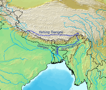
| Description | Map of the Brahmaputra/Yarlung Tsangpo river. |
| Date | |
| Source | Self-made, based on the DEMIS map server. |
| Author | Kmusser |
I, the copyright holder of this work, hereby publish it under the following license:
This file is licensed under the Creative Commons Attribution-Share Alike 2.5 Generic license.
- You are free:
- to share – to copy, distribute and transmit the work
- to remix – to adapt the work
- Under the following conditions:
- attribution – You must give appropriate credit, provide a link to the license, and indicate if changes were made. You may do so in any reasonable manner, but not in any way that suggests the licensor endorses you or your use.
- share alike – If you remix, transform, or build upon the material, you must distribute your contributions under the same or compatible license as the original.
File history
Click on a date/time to view the file as it appeared at that time.
| Date/Time | Thumbnail | Dimensions | User | Comment | |
|---|---|---|---|---|---|
| current | 12:06, 12 March 2019 | | 449 × 381 (308 KB) | Maphobbyist (talk | contribs) | Reverted to version as of 10:19, 21 February 2019 (UTC) |
| 12:18, 22 February 2019 |  | 449 × 381 (161 KB) | FakeDJT (talk | contribs) | Reverted to version as of 08:24, 13 December 2018 (UTC) | |
| 10:19, 21 February 2019 |  | 449 × 381 (308 KB) | Maphobbyist (talk | contribs) | Reverted to version as of 19:02, 26 September 2007 (UTC) | |
| 08:26, 13 December 2018 |  | 449 × 381 (161 KB) | FakeDJT (talk | contribs) | Reverted to version as of 08:24, 13 December 2018 (UTC) | |
| 08:25, 13 December 2018 |  | 449 × 381 (308 KB) | FakeDJT (talk | contribs) | Reverted to version as of 19:02, 26 September 2007 (UTC) | |
| 08:24, 13 December 2018 |  | 449 × 381 (161 KB) | FakeDJT (talk | contribs) | Fix | |
| 19:02, 26 September 2007 |  | 449 × 381 (308 KB) | Kmusser (talk | contribs) | {{Information |Description=Map of the Brahmaputra/Yarlung Tsangpo river. |Source=Self-made, based on the [http://www2.demis.nl/mapserver/mapper.asp DEMIS map server]. |Date=September 26, 2007 |
You cannot overwrite this file.
File usage on Commons
The following 9 pages use this file:
- User:Chumwa/OgreBot/Potential transport maps/2018 December 11-20
- User:Chumwa/OgreBot/Potential transport maps/2019 February 19-28
- User:Chumwa/OgreBot/Potential transport maps/2019 March 11-20
- User:Chumwa/OgreBot/Transport Maps/2018 December 11-20
- User:Chumwa/OgreBot/Transport Maps/2019 February 19-28
- User:Chumwa/OgreBot/Transport Maps/2019 March 11-20
- User:Chumwa/OgreBot/Travel and communication maps/2018 December 11-20
- User:Chumwa/OgreBot/Travel and communication maps/2019 February 19-28
- User:Chumwa/OgreBot/Travel and communication maps/2019 March 11-20
File usage on other wikis
The following other wikis use this file:
- Usage on af.wikipedia.org
- Usage on be.wikipedia.org
- Usage on bg.wikipedia.org
- Usage on bn.wikipedia.org
- Usage on bo.wikipedia.org
- Usage on ca.wikipedia.org
- Usage on cy.wikipedia.org
- Usage on de.wikipedia.org
- Usage on en.wikipedia.org
- Usage on es.wikipedia.org
- Usage on gl.wikipedia.org
- Usage on hi.wikipedia.org
- Usage on ja.wikipedia.org
- Usage on jv.wikipedia.org
- Usage on kn.wikipedia.org
- Usage on ko.wikipedia.org
- Usage on nl.wikipedia.org
- Usage on nn.wikipedia.org
- Usage on no.wikipedia.org
- Usage on oc.wikipedia.org
- Usage on pl.wikipedia.org
- Usage on pnb.wikipedia.org
- Usage on ro.wikipedia.org
- Usage on sk.wikipedia.org
- Usage on sv.wikipedia.org
- Usage on sw.wikipedia.org
- Usage on zh.wikipedia.org