Category:Maps of borders of China
Jump to navigation
Jump to search
Countries of Asia: Afghanistan · Armenia‡ · Azerbaijan‡ · Bhutan · Cambodia · People's Republic of China · Cyprus‡ · Egypt‡ · India · Indonesia‡ · Iran · Iraq · Israel · Jordan · Kuwait · Kyrgyzstan · Laos · Lebanon · Malaysia · Myanmar · Nepal · North Korea · Pakistan · Russia‡ · Saudi Arabia · South Korea · Syria · Tajikistan · Thailand · Turkey‡ · Vietnam
‡: partly located in Asia
‡: partly located in Asia
Subcategories
This category has only the following subcategory.
M
Media in category "Maps of borders of China"
The following 53 files are in this category, out of 53 total.
-
 1963 China-India Border (30848757436).jpg 1,472 × 956; 1.01 MB
-
 Bhutan china dispute.jpg 661 × 372; 62 KB
-
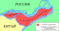
 Bolshoy Ussuriysky and Tarabarov EN.svg 2,453 × 1,280; 487 KB
-
 Bolshoy Ussuriysky and Tarabarov MK.svg 2,453 × 1,280; 396 KB
-
 Bolshoy Ussuriysky and Tarabarov RU.svg 2,453 × 1,280; 428 KB
-
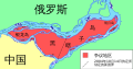 Bolshoy Ussuriysky and Tarabarov ZH.svg 2,453 × 1,280; 365 KB
-
 Brahmaputrarivermap.png 449 × 381; 308 KB
-
 Burma-China border map.jpg 742 × 1,008; 283 KB
-
 Burma-China border map2.jpg 742 × 1,008; 238 KB
-
 Buryatia - russian ostrog.svg 1,359 × 915; 171 KB
-
 China India eastern border 88.jpg 1,019 × 1,265; 297 KB
-
 China India western border 88.jpg 1,038 × 1,262; 312 KB
-
 China Nepal border.png 1,070 × 764; 319 KB
-
 China USSR E 88.jpg 1,030 × 1,278; 342 KB
-
 China-India relief location map.jpg 1,183 × 617; 320 KB
-
 China-Laos border map.png 850 × 1,171; 414 KB
-
 China-North Korea border.jpg 852 × 675; 134 KB
-
 China-Russia border - protocol of Chuguchak 1864.jpg 935 × 900; 674 KB
-
 China-Russia Frontier 1890 - Amur Manchuria.jpg 18,060 × 14,024; 31.96 MB
-
 China-USSR border map (eastern section).png 1,348 × 1,373; 3.17 MB
-
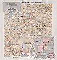 China-USSR Border Western Sector.jpg 989 × 1,043; 200 KB
-
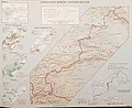 China-USSR Boundary (Western Section).jpg 3,104 × 2,537; 3.6 MB
-
 China-Vietnam border map.jpg 992 × 740; 230 KB
-
 Chinese-Pak border map.png 1,199 × 877; 313 KB
-
 CHN - VTN border map.jpg 2,341 × 3,016; 2.03 MB
-
 Dauria and Amur region 1650-55 cz.svg 1,985 × 1,281; 162 KB
-
 Dauria and Amur region 1652-58 cz.svg 1,985 × 1,281; 213 KB
-
 Dauria and Amur region 1683-84 cz.svg 1,985 × 1,281; 200 KB
-
 Dauria and Amur region 1685 cz.svg 1,985 × 1,281; 184 KB
-
 Dauria and Amur region 1686-88 cz.svg 1,985 × 1,281; 189 KB
-
 Dauria and Amur region 1689 cz.svg 1,985 × 1,281; 174 KB
-
 East China Sea natural gas field problem (China - Japan) NT.PNG 560 × 600; 58 KB
-
 Himalaya political map EN.svg 1,481 × 1,000; 951 KB
-
 Himalaya political map NL.svg 1,481 × 1,000; 947 KB
-
 MacMahon Line.jpg 750 × 528; 46 KB
-
 MANCHURIA-U.S.S.R BOUNDARY Ct002999.jpg 4,167 × 3,185; 4.25 MB
-
 Manchuria-U.S.S.R. boundary. LOC 2007627809.jpg 4,167 × 3,185; 1.33 MB
-
 Manchuria-U.S.S.R. boundary. LOC 2007627809.tif 4,167 × 3,185; 37.97 MB
-
 Map of Doklam.svg 474 × 455; 185 KB
-
 Map of the Amur−Heilongjiang region.jpg 423 × 611; 64 KB
-
 Map of Tibet in 1798, from- Map China c1798 (cropped).jpg 348 × 255; 40 KB
-
 MapOfBolshoyUssuriyskyIsland.gif 505 × 375; 132 KB
-
 MapOfBolshoyUssuriyskyIsland.PNG 479 × 369; 173 KB
-
 Northern Frontier 1899, 1905, 1963.png 1,938 × 1,935; 3 MB
-
 Poamuří kolonizace.svg 1,354 × 779; 174 KB
-
 Sino-russian border after treaty of Nerchinsk.svg 1,985 × 1,281; 196 KB
-
 Sino-Russian border conflicts cz.svg 1,985 × 1,281; 222 KB
-
 Sino-Russian border conflicts es.svg 1,985 × 1,281; 395 KB
-
 SinoVietnamBorderMarker.jpg 2,794 × 1,633; 3.85 MB
-

-
-
-
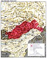
 Истоки территориальных претензий КНР к РФ.jpg 2,084 × 1,593; 415 KB
.jpg)


.png)

.jpg)


_NT.PNG)


.jpg)


_Map_1_(of_3)_Eastern_Border_Section.png)
_Map_2_(of_3)_Central_Border_Section.png)
_Map_3_(of_3)_Western_Border_Section.png)
