File:Black-river-boundary.pdf
Jump to navigation
Jump to search

Size of this JPG preview of this PDF file: 463 × 599 pixels. Other resolutions: 185 × 240 pixels | 371 × 480 pixels | 593 × 768 pixels | 1,275 × 1,650 pixels.
Original file (1,275 × 1,650 pixels, file size: 73 KB, MIME type: application/pdf)
Captions
Captions
Add a one-line explanation of what this file represents
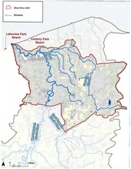
| Description | Watershed of Ohio's Black River, showing the EPA's "area of concern" (AOC) | |||||
| Source | https://www.epa.gov/black-river-aoc/black-river-aoc-boundary-map | |||||
| Author | ||||||
| Permission (Reusing this file) |
|
File history
Click on a date/time to view the file as it appeared at that time.
| Date/Time | Thumbnail | Dimensions | User | Comment | |
|---|---|---|---|---|---|
| current | 18:38, 15 August 2016 |  | 1,275 × 1,650 (73 KB) | Geo Swan (talk | contribs) | {{Information |Description=Watershed of Ohio's Black River, showing the EPA's "area of concern" (AOC) |Source=https://www.epa.gov/black-river-aoc/black-river-aoc-boundary-map |Date= |Author= |Permission={{PD-USGov-EPA}} |other_versions= }} [[Category:... |
You cannot overwrite this file.
File usage on Commons
There are no pages that use this file.