File:Andalucía-loc.svg
Jump to navigation
Jump to search

Size of this PNG preview of this SVG file: 512 × 345 pixels. Other resolutions: 320 × 216 pixels | 640 × 431 pixels | 1,024 × 690 pixels | 1,280 × 863 pixels | 2,560 × 1,725 pixels.
Original file (SVG file, nominally 512 × 345 pixels, file size: 1.22 MB)
Captions
Captions
Add a one-line explanation of what this file represents
Summary[edit]
| Description |
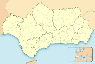
English: Location map of Andalusia
Equirectangular projection, N/S stretching 130 %. Geographic limits of the map:
Español: Mapa de localización de Andalucía
Proyección equirrectangular, N/S estirada 130 %. Límites geográficos del mapa:
|
|
| Date | ||
| Source | Own work based on: EspañaLoc.svg | |
| Author | Miguillen | |
| SVG development | This locator map was created with Inkscape.
|
Licensing[edit]
I, the copyright holder of this work, hereby publish it under the following licenses:

|
Permission is granted to copy, distribute and/or modify this document under the terms of the GNU Free Documentation License, Version 1.2 or any later version published by the Free Software Foundation; with no Invariant Sections, no Front-Cover Texts, and no Back-Cover Texts. A copy of the license is included in the section entitled GNU Free Documentation License. |
This file is licensed under the Creative Commons Attribution-Share Alike 4.0 International, 3.0 Unported, 2.5 Generic, 2.0 Generic and 1.0 Generic license.
- You are free:
- to share – to copy, distribute and transmit the work
- to remix – to adapt the work
- Under the following conditions:
- attribution – You must give appropriate credit, provide a link to the license, and indicate if changes were made. You may do so in any reasonable manner, but not in any way that suggests the licensor endorses you or your use.
- share alike – If you remix, transform, or build upon the material, you must distribute your contributions under the same or compatible license as the original.
You may select the license of your choice.
File history
Click on a date/time to view the file as it appeared at that time.
| Date/Time | Thumbnail | Dimensions | User | Comment | |
|---|---|---|---|---|---|
| current | 14:45, 4 November 2023 | | 512 × 345 (1.22 MB) | Lojwe (talk | contribs) | Removing frame |
| 20:27, 18 April 2012 |  | 512 × 345 (1.22 MB) | Miguillen (talk | contribs) | Reverted to version as of 21:38, 21 May 2010 | |
| 03:28, 18 April 2012 |  | 512 × 345 (1.64 MB) | Chipmunkdavis (talk | contribs) | Replacing inset of Europe with inset of Spain | |
| 21:38, 21 May 2010 |  | 512 × 345 (1.22 MB) | Miguillen (talk | contribs) | Comarca Campo de Gibraltar | |
| 16:35, 18 May 2010 |  | 512 × 345 (1.22 MB) | Miguillen (talk | contribs) | border | |
| 16:07, 18 May 2010 |  | 512 × 345 (1.22 MB) | Miguillen (talk | contribs) | border | |
| 15:27, 18 May 2010 |  | 512 × 344 (1.31 MB) | Miguillen (talk | contribs) | == {{int:filedesc}} == {{Information |Description= {{en|Location map of Andalusia}} Equirectangular projection, N/S stretching 130 %. Geographic limits of the map: * N: 38.015990° N * S: 36.558500° N * W: 3.241750° O * E: 1.50770 |
You cannot overwrite this file.
File usage on Commons
There are no pages that use this file.
File usage on other wikis
The following other wikis use this file:
- Usage on an.wikipedia.org
- Sevilla
- Malaga
- Comares
- Chaén
- Almería
- Granada
- Alameda (Malaga)
- Monda
- Coín
- Alhaurín de la Torre
- Ronda (Malaga)
- Alamedilla
- Alfarnate
- El Padul
- Cordoba
- Almuñécar
- Xerez de la Frontera
- Alchecira (Cádiz)
- Uelba
- Cádiz
- Marbella
- Láchar
- Torrecampo
- Alcaracejos
- Añora
- Belalcázar
- Cardeña
- Conquista (Cordoba)
- Dos Torres
- El Guijo
- El Viso
- Fuente la Lancha
- Hinojosa del Duque
- Pedroche
- Pozoblanco
- Santa Eufemia (Cordoba)
- Villanueva del Duque
- Villaralto
- Villanueva de Córdoba
- Baena
- Castro del Río
- Espejo
- Nueva Carteya
- Valenzuela
- Almedinilla
- Benamejí
- Cabra (Cordoba)
- Carcabuey
- Doña Mencía
- Encinas Reales
View more global usage of this file.