File:A mapp of the greate River Ganges. As it emptieth itself into the Bay of Bengala. Taken from a draught made uppon the place, by the agents for the English East India Company never before made publique. By John Thornton RMG F0239.tiff

Original file (7,248 × 6,000 pixels, file size: 124.42 MB, MIME type: image/tiff)
Captions
Captions
Summary[edit]
| Author |
Thornton, John; Thornton |
| Description |
English: A mapp of the greate River Ganges. As it emptieth itself into the Bay of Bengala. Taken from a draught made uppon the place, by the agents for the English East India Company never before made publique. By John Thornton Hydrographer to the Hono.ble East India Company. At the signe of England, Scotland & Ireland in the Minories, London.Single sheet. Hand col. engr. Scale: [ca. 1:2 750 000 (bar)]. Cartographic Note: Borders graduated for latitude. Some soundings. Scale in miles. Additional Places: India, Bangladesh, Ganga. Contents Note: Cartouche with figures. Dedication cartouche, to East India Company. Elephants and cities depicted on land, ships on the sea.
This chart was published in Thornton's Atlas Maritimus of 1685 (copy at PBD8515). |
| Date | 1685 |
| Dimensions | Printed area 45 x 55cm, on sheet 55 x 66cm. |
| Source/Photographer | http://collections.rmg.co.uk/collections/objects/540603 |
| Permission (Reusing this file) |
The original artefact or artwork has been assessed as public domain by age, and faithful reproductions of the two dimensional work are also public domain. No permission is required for reuse for any purpose. The text of this image record has been derived from the Royal Museums Greenwich catalogue and image metadata. Individual data and facts such as date, author and title are not copyrightable, but reuse of longer descriptive text from the catalogue may not be considered fair use. Reuse of the text must be attributed to the "National Maritime Museum, Greenwich, London" and a Creative Commons CC-BY-NC-SA-3.0 license may apply if not rewritten. Refer to Royal Museums Greenwich copyright. |
| Identifier | id number: G255:1/1 |
| Collection | Charts and maps |
Licensing[edit]
|
This is a faithful photographic reproduction of a two-dimensional, public domain work of art. The work of art itself is in the public domain for the following reason:
The official position taken by the Wikimedia Foundation is that "faithful reproductions of two-dimensional public domain works of art are public domain".
This photographic reproduction is therefore also considered to be in the public domain in the United States. In other jurisdictions, re-use of this content may be restricted; see Reuse of PD-Art photographs for details. | ||||
File history
Click on a date/time to view the file as it appeared at that time.
| Date/Time | Thumbnail | Dimensions | User | Comment | |
|---|---|---|---|---|---|
| current | 13:48, 22 August 2017 | 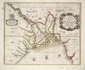 | 7,248 × 6,000 (124.42 MB) | Fæ (talk | contribs) | Royal Museums Greenwich Charts and maps, http://collections.rmg.co.uk/collections/objects/540603 |
You cannot overwrite this file.
File usage on Commons
The following page uses this file: