File:A map of New England, and Nova Scotia, with part of New York, Canada, and New Britain & the adjacent islands of New Found Land, Cape Breton &c. (4231924992).jpg
Jump to navigation
Jump to search
Size of this preview: 726 × 600 pixels. Other resolutions: 291 × 240 pixels | 581 × 480 pixels | 930 × 768 pixels | 1,240 × 1,024 pixels | 2,000 × 1,652 pixels.
Original file (2,000 × 1,652 pixels, file size: 3.54 MB, MIME type: image/jpeg)
Captions
Captions
Add a one-line explanation of what this file represents
Summary[edit]
.jpg&action=edit§ion=1)
| Description |
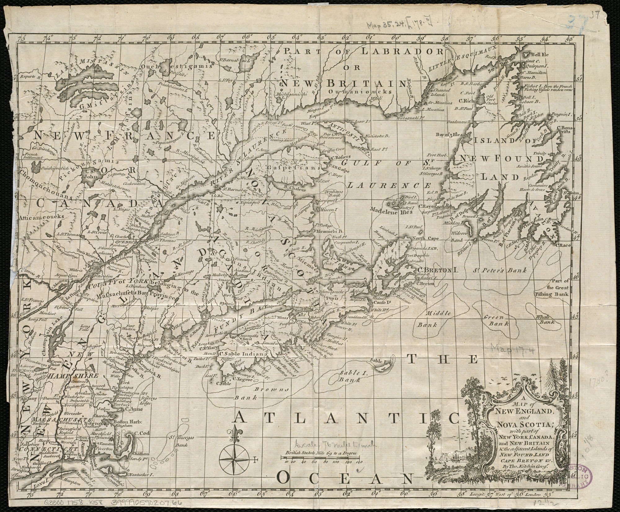
Zoom into this map at maps.bpl.org. Author: Kitchin, Thomas Date: 1758 Location: Canada, Eastern, Cape Breton Island (N.S.), Labrador, New England, New Foundland, North America, Nova Scotia Dimension: 26x33cm Scale: ca. 1:4,800,000 Call Number: G3300 1758 .K58 |
| Date | |
| Source | A map of New England, and Nova Scotia, with part of New York, Canada, and New Britain & the adjacent islands of New Found Land, Cape Breton &c. |
| Author | http://maps.bpl.org |
Licensing[edit]
.jpg&action=edit§ion=2)
This file is licensed under the Creative Commons Attribution 2.0 Generic license.
- You are free:
- to share – to copy, distribute and transmit the work
- to remix – to adapt the work
- Under the following conditions:
- attribution – You must give appropriate credit, provide a link to the license, and indicate if changes were made. You may do so in any reasonable manner, but not in any way that suggests the licensor endorses you or your use.
This work is in the public domain in the United States because it was published (or registered with the U.S. Copyright Office) before January 1, 1929.
Public domain works must be out of copyright in both the United States and in the source country of the work in order to be hosted on the Commons. If the work is not a U.S. work, the file must have an additional copyright tag indicating the copyright status in the source country.
Note: This tag should not be used for sound recordings. |
| This image, originally posted to Flickr, was reviewed on 21 August 2013 by the administrator or reviewer File Upload Bot (Magnus Manske), who confirmed that it was available on Flickr under the stated license on that date. |
File history
Click on a date/time to view the file as it appeared at that time.
| Date/Time | Thumbnail | Dimensions | User | Comment | |
|---|---|---|---|---|---|
| current | 04:18, 21 August 2013 | | 2,000 × 1,652 (3.54 MB) | File Upload Bot (Magnus Manske) (talk | contribs) | Transferred from Flickr by User:tm |
You cannot overwrite this file.
File usage on Commons
The following page uses this file:
- File:Nova Scotia 1763.jpg (file redirect)
File usage on other wikis
The following other wikis use this file:
- Usage on de.wikipedia.org
.jpg&oldid=874896622)