File:1780 Cook - Hogg Map of Tahiti ( Society Islands ) - Geographicus - Tahiti-hogg-1780.jpg

Original file (4,000 × 2,138 pixels, file size: 912 KB, MIME type: image/jpeg)
Captions
Captions
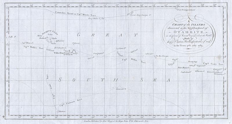
| A Chart of the Islands discovered in the Neighbourhood of Otaheite, in the Course of Several Voyages round the World Made by the Capts. Byron, Wallis, Carteret, & Cook. | |||||||
|---|---|---|---|---|---|---|---|
| Artist | |||||||
| Title |
A Chart of the Islands discovered in the Neighbourhood of Otaheite, in the Course of Several Voyages round the World Made by the Capts. Byron, Wallis, Carteret, & Cook. |
||||||
| Description |
English: This is a rare map of the Society Islands in the South Pacific published by Alexander Hogg to illustrate the voyages and discoveries of the sea captains Byron, Wallis, Carteret ad Cook. This map contains references to the cartographic work of John Hawkesworth (1715?-1773), James Cook (1728-1779), Sir Joseph Banks ( 1743-1820) and John Byron (1723-1786). Features the routes taken by these important explorers in and around the Society Islands. Depicts the island of Tahiti (Otaheite) as well as Bora Bora (Bolabola), Otaha, Marma, Ulietea, and others. Decorative title cartouche in the upper right quadrant. Published for Hogg’s account of Cook’s Voyages, c.1780. |
||||||
| Date |
1780 date QS:P571,+1780-00-00T00:00:00Z/9 |
||||||
| Dimensions |
height: 7.5 in (19 cm); width: 14 in (35.5 cm) dimensions QS:P2048,7.5U218593 dimensions QS:P2049,14U218593 |
||||||
| Accession number |
Geographicus link: Tahiti-hogg-1780 |
||||||
| Source/Photographer |
An account of the voyages undertaken by the order of His present Majesty for making discoveries in the Southern Hemisphere, and successively performed by Commodore Byron, Captain Wallis, Captain Carteret, and Captain Cook, in the Dolphin, the Swallow, and the Endeavor. Drawn up from the journals which were kept by the several commanders, and from the papers of Joseph Banks, Esq; by John Hawkesworth, LL.D. In three volumes. Illustrated with cuts, and a great variety of charts and maps relative to countries now first discovered, or hitherto but imperfectly known. London: printed for W. Strahan; and T. Cadell in the Strand, MDCCLXXIII.
|
||||||
| Permission (Reusing this file) |
|
||||||
File history
Click on a date/time to view the file as it appeared at that time.
| Date/Time | Thumbnail | Dimensions | User | Comment | |
|---|---|---|---|---|---|
| current | 00:24, 25 March 2011 |  | 4,000 × 2,138 (912 KB) | BotMultichillT (talk | contribs) | {{subst:User:Multichill/Geographicus |link=http://www.geographicus.com/P/AntiqueMap/Tahiti-hogg-1780 |product_name=1780 Cook / Hogg Map of Tahiti ( Society Islands ) |map_title=A Chart of the Islands discovered in the Neighbourhood of Otaheite, in the Cou |
You cannot overwrite this file.
File usage on Commons
The following page uses this file:
Structured data
Items portrayed in this file
depicts
image/jpeg
6c85281efb31070eb126538baebc647954fca16f
934,255 byte
2,138 pixel
4,000 pixel
- Maps of the Society Islands
- James Cook (maps relating to)
- Samuel Wallis
- John Byron
- Philip Carteret
- Maps of voyages
- Old maps of the history of Oceania
- Old maps of Polynesia
- 1780 maps
- English-language maps
- An account of the voyages undertaken by the order of His present Majesty for making discoveries in the Southern Hemisphere