| №
|
Name
|
Upload
|
Photo
|
Category
|
Type[1]
|
Region(s)
|
Wikidata
|
Location
|
|
|
Giant's Causeway
|

|
yes
|
Giant's Causeway
|
WHS, AONB, NR
|
County Antrim
|
Q106187
|
55°14′28″N 6°30′43″W / 55.241°N 6.512°W / 55.241; -6.512
|
| Ireland/6453
|
Marble Arch Caves Global Geopark
|
|
yes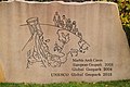
|
Marble Arch Caves Global Geopark
|
GP
|
County Fermanagh
County Cavan
|
Q6755158
|
54°15′29″N 7°48′50″W / 54.258°N 7.814°W / 54.258; -7.814
|
| 958
|
Belfast Lough
|
|
yes
|
Belfast Lough
|
RS
|
County Antrim
County Down
|
Q2360948
|
54°41′28″N 5°47′06″W / 54.691°N 5.785°W / 54.691; -5.785
|
|
|
Belshaw's Quarry Nature Reserve
|
|
yes
|
Belshaw's Quarry Nature Reserve
|
NR
|
County Antrim
|
Q112572416
|
54°32′13″N 6°06′07″W / 54.537°N 6.102°W / 54.537; -6.102
|
| UK0030097
|
Breen Wood/Breen Oakwood Nature Reserve
|
|
yes
|
Breen Oakwood Nature Reserve
|
SAC, NR
|
County Antrim
|
Q112572441
|
55°08′17″N 6°14′17″W / 55.138°N 6.238°W / 55.138; -6.238
|
| 969, UK0016606
|
Garron Plateau
|
|
yes
|
Garron Plateau
|
RS, SAC
|
County Antrim
|
Q48803825
|
54°58′59″N 6°04′59″W / 54.983°N 6.083°W / 54.983; -6.083
|
| 1042, UK0016610
|
Garry Bog
|
|
yes
|
Garry Bog
|
RS, SAC
|
County Antrim
|
|
55°06′00″N 6°31′01″W / 55.100°N 6.517°W / 55.100; -6.517
|
|
|
Glenariff Nature Reserve
|
|
yes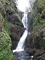
|
Glenariff Forest Park
|
NR
|
County Antrim
|
Q3364373
|
55°00′36″N 6°07′16″W / 55.010°N 6.121°W / 55.010; -6.121
|
|
|
Rathlin Kebble Nature Reserve
|
|
yes
|
Kebble Nature Reserve
|
NR
|
County Antrim
|
|
55°17′56″N 6°12′07″W / 55.299°N 6.202°W / 55.299; -6.202
|
| 895
|
Larne Lough
|
|
yes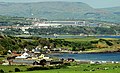
|
Larne Lough
|
RS
|
County Antrim
|
Q3756436
|
54°49′41″N 5°47′24″W / 54.828°N 5.790°W / 54.828; -5.790
|
| UK0030199
|
Main Valley Bogs
|
|
|
Main Valley Bogs
|
SAC
|
County Antrim
|
|
55°00′43″N 6°22′59″W / 55.012°N 6.383°W / 55.012; -6.383
|
| UK0030214
|
Montiaghs Moss
|
|
|
Montiaghs Moss
|
SAC
|
County Antrim
|
|
54°31′30″N 6°18′54″W / 54.525°N 6.315°W / 54.525; -6.315
|
| UK0030224
|
North Antrim Coast
|
|
yes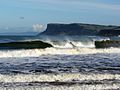
|
North Antrim Coast
|
SAC
|
County Antrim
|
Q112572468
|
55°13′59″N 6°23′35″W / 55.233°N 6.393°W / 55.233; -6.393
|
|
|
Portrush Nature Reserve
|
|
|
Portrush Nature Reserve
|
NR
|
County Antrim
|
|
55°12′29″N 6°39′14″W / 55.208°N 6.654°W / 55.208; -6.654
|
|
|
Randalstown Forest Nature Reserve
|
|
yes
|
Randalstown Forest Nature Reserve
|
NR
|
County Antrim
|
Q112579273
|
54°43′48″N 6°19′55″W / 54.730°N 6.332°W / 54.730; -6.332
|
| UK0030055
|
Rathlin Island
|
|
yes
|
Rathlin Island
|
SAC
|
County Antrim
|
Q1136111
|
55°18′00″N 6°13′01″W / 55.300°N 6.217°W / 55.300; -6.217
|
| UK0030244
|
Rea's Wood and Farr's Bay/Rea's Wood Nature Reserve
|
|
yes
|
Rea's Wood and Farr's Bay
|
SAC, NR
|
County Antrim
|
|
54°42′25″N 6°13′41″W / 54.707°N 6.228°W / 54.707; -6.228
|
|
|
Slieveanorra Nature Reserve
|
|
yes
|
Slieveanorra
|
NR
|
County Antrim
|
Q2738023
|
55°02′35″N 6°12′43″W / 55.043°N 6.212°W / 55.043; -6.212
|
|
|
Straidkilly Nature Reserve
|
|
|
Straidkilly Nature Reserve
|
NR
|
County Antrim
|
|
54°58′44″N 5°58′05″W / 54.979°N 5.968°W / 54.979; -5.968
|
|
|
Brackagh Nature Reserve
|
|
|
Brackagh Nature Reserve
|
NR
|
County Armagh
|
|
54°23′49″N 6°26′02″W / 54.397°N 6.434°W / 54.397; -6.434
|
|
|
Oxford Island Nature Reserve
|
|
yes
|
Oxford Island
|
NR
|
County Armagh
|
Q24673838
|
54°29′24″N 6°22′30″W / 54.490°N 6.375°W / 54.490; -6.375
|
| UK0030277
|
Slieve Gullion
|
|
yes
|
Slieve Gullion
|
SAC
|
County Armagh
|
Q823575
|
54°07′41″N 6°26′06″W / 54.128°N 6.435°W / 54.128; -6.435
|
| UK0016607
|
Pettigo Plateau
|
|
|
Pettigo Plateau
|
NR, RS, SAC
|
County Fermanagh
|
|
54°36′58″N 7°56′46″W / 54.616°N 7.946°W / 54.616; -7.946
|
| UK0030318
|
Aughnadarragh Lough
|
|
|
Aughnadarragh Lough
|
SAC
|
County Down
|
|
54°27′47″N 5°46′26″W / 54.463°N 5.774°W / 54.463; -5.774
|
| UK0030319
|
Ballykilbeg
|
|
yes
|
Ballykilbeg
|
SAC
|
County Down
|
Q104363217
|
54°17′38″N 5°46′34″W / 54.294°N 5.776°W / 54.294; -5.776
|
| UK0016620
|
Derryleckagh
|
|
yes
|
Derryleckagh
|
SAC
|
County Down
|
Q104359043
|
54°09′54″N 6°17′10″W / 54.165°N 6.286°W / 54.165; -6.286
|
|
|
Ballyquintin National Nature Reserve
|
|
yes
|
Ballyquintin Point
|
NR
|
County Down
|
Q24656370
|
54°19′59″N 5°30′00″W / 54.333°N 5.500°W / 54.333; -5.500
|
|
|
Bohill Nature Reserve
|
|
yes
|
Bohill Nature Reserve
|
NR
|
County Down
|
Q22000358
|
54°20′49″N 5°50′38″W / 54.347°N 5.844°W / 54.347; -5.844
|
| 936
|
Carlingford Lough
|
|
yes
|
Carlingford Lough
|
RS
|
County Down
|
Q2369538
|
54°40′19″N 7°01′16″W / 54.672°N 7.021°W / 54.672; -7.021
|
|
|
Cloghy Rocks Nature Reserve
|
|
yes
|
Cloghy Rocks Nature Reserve
|
NR
|
County Down
|
|
54°21′14″N 5°33′04″W / 54.354°N 5.551°W / 54.354; -5.551
|
|
|
The Dorn Nature Reserve
|
|
|
The Dorn Nature Reserve
|
NR
|
County Down
|
|
54°26′17″N 5°32′46″W / 54.438°N 5.546°W / 54.438; -5.546
|
| UK0016615
|
Eastern Mournes
|
|
yes
|
Eastern Mournes
|
SAC
|
County Down
|
|
54°10′30″N 5°57′58″W / 54.175°N 5.966°W / 54.175; -5.966
|
|
|
Granagh Bay Nature Reserve
|
|
yes
|
Granagh Bay Nature Reserve
|
NR
|
County Down
|
|
54°21′36″N 5°31′48″W / 54.360°N 5.530°W / 54.360; -5.530
|
| UK0030169
|
Hollymount Forest National Nature Reserve
|
|
|
Hollymount Forest
|
NR, SAC
|
County Down
|
|
54°19′23″N 5°44′42″W / 54.323°N 5.745°W / 54.323; -5.745
|
|
|
Killard National Nature Reserve
|
|
|
Killard National Nature Reserve
|
NR
|
County Down
|
|
53°52′52″N 9°45′29″W / 53.881°N 9.758°W / 53.881; -9.758
|
| 2278
|
Killough Bay
|
|
|
Killough Bay
|
RS
|
County Down
|
Q24640076
|
54°15′00″N 5°37′01″W / 54.250°N 5.617°W / 54.250; -5.617
|
| UK0030180
|
Lecale Fens
|
|
|
Lecale Fens
|
SAC
|
County Down
|
|
54°16′37″N 5°46′16″W / 54.277°N 5.771°W / 54.277; -5.771
|
| UK0016612
|
Murlough Nature Reserve
|
|
yes
|
Murlough National Nature Reserve
|
NR, SAC
|
County Down
|
Q15260305
|
54°12′40″N 5°46′59″W / 54.211°N 5.783°W / 54.211; -5.783
|
| 2279
|
Outer Ards
|
|
|
Outer Ards
|
RS
|
County Down
|
|
54°31′59″N 5°31′01″W / 54.533°N 5.517°W / 54.533; -5.517
|
|
|
Quoile Pondage National Nature Reserve
|
|
yes
|
Quoile Pondage National Nature Reserve
|
NR
|
County Down
|
|
54°21′47″N 5°41′24″W / 54.363°N 5.690°W / 54.363; -5.690
|
| UK0030268
|
Rostrevor Wood/Rostrevor Oakwood Nature Reserve
|
|
yes
|
Rostrevor Forest
|
SAC, AONB, NR
|
County Down
|
Q20713832
|
54°05′28″N 6°11′13″W / 54.091°N 6.187°W / 54.091; -6.187
|
| 937, UK0016618
|
Strangford Lough
|
|
yes
|
Strangford Lough
|
RS, SAC, NR
|
County Down
|
Q937070
|
54°28′59″N 5°34′59″W / 54.483°N 5.583°W / 54.483; -5.583
|
| 1178, UK0030291
|
Turmennan Fen Nature Reserve/Turmennan Lough
|
|
|
Turmennan Fen Nature Reserve
|
RS, SAC, NR
|
County Down
|
|
54°22′44″N 5°42′50″W / 54.379°N 5.714°W / 54.379; -5.714
|
|
|
Castle Archdale Islands Nature Reserve
|
|
yes
|
Castle Archdale Islands Nature Reserve
|
NR
|
County Fermanagh
|
|
54°29′24″N 7°46′05″W / 54.490°N 7.768°W / 54.490; -7.768
|
|
|
Castle Caldwell Nature Reserve
|
|
yes
|
Castle Caldwell Forest Park
|
NR
|
County Fermanagh
|
Q65107116
|
54°29′35″N 7°58′41″W / 54.493°N 7.978°W / 54.493; -7.978
|
|
|
Correl Glen Nature Reserve
|
|
yes
|
Correl Glen Nature Reserve
|
NR
|
County Fermanagh
|
|
54°26′24″N 7°53′10″W / 54.440°N 7.886°W / 54.440; -7.886
|
| UK0030116
|
Cladagh (Swanlinbar) River
|
|
|
River Cladagh (Swanlinbar)
|
SAC
|
County Fermanagh
|
Q14474933
|
54°13′08″N 7°37′52″W / 54.219°N 7.631°W / 54.219; -7.631
|
| UK0016603
|
Cuilcagh Mountain
|
|
yes
|
Cuilcagh Mountain
|
RS, SAC
|
County Fermanagh
|
Q3544420
|
54°12′00″N 7°48′40″W / 54.200°N 7.811°W / 54.200; -7.811
|
| 1177, UK0030068
|
Fardrum and Roosky Turloughs
|
|
yes
|
Fardrum and Roosky Turloughs
|
RS, SAC
|
County Fermanagh
|
|
54°24′00″N 7°43′01″W / 54.400°N 7.717°W / 54.400; -7.717
|
|
|
Hanging Rock and Rossaa Forest Nature Reserve
|
|
|
Hanging Rock and Rossaa Forest Nature Reserve
|
NR
|
County Fermanagh
|
Q5648004
|
54°15′25″N 7°42′14″W / 54.257°N 7.704°W / 54.257; -7.704
|
|
|
Killykeeghan and Crossmurrin Nature Reserve
|
|
|
Killykeeghan and Crossmurrin Nature Reserve
|
NR
|
County Fermanagh
|
|
54°15′22″N 7°50′02″W / 54.256°N 7.834°W / 54.256; -7.834
|
| UK0030045
|
Largalinny
|
|
|
Largalinny
|
SAC
|
County Fermanagh
|
|
54°25′55″N 7°53′13″W / 54.432°N 7.887°W / 54.432; -7.887
|
| UK0030047
|
Lough Melvin
|
|
yes
|
Lough Melvin
|
SAC
|
County Fermanagh
|
Q3776146
|
54°25′37″N 8°07′19″W / 54.427°N 8.122°W / 54.427; -8.122
|
| UK0016621
|
Magheraveely Marl Loughs
|
|
|
Magheraveely Marl Loughs
|
SAC
|
County Fermanagh
|
|
54°11′20″N 7°16′01″W / 54.189°N 7.267°W / 54.189; -7.267
|
| UK0016619
|
Monawilkin
|
|
|
Monawilkin
|
SAC
|
County Fermanagh
|
|
54°25′44″N 7°51′40″W / 54.429°N 7.861°W / 54.429; -7.861
|
| UK0030212
|
Moninea Bog
|
|
|
Moninea Bog
|
SAC
|
County Fermanagh
|
|
54°08′31″N 7°32′35″W / 54.142°N 7.543°W / 54.142; -7.543
|
|
|
Reilly and Gole Woods Nature Reserve
|
|
|
Reilly and Gole Woods Nature Reserve
|
NR
|
County Fermanagh
|
|
54°10′12″N 7°29′06″W / 54.170°N 7.485°W / 54.170; -7.485
|
| 896, UK0016614
|
Upper Lough Erne
|
|
yes
|
Upper Lough Erne
|
RS, SAC
|
County Fermanagh
|
Q11878874
|
54°13′41″N 7°32′24″W / 54.228°N 7.540°W / 54.228; -7.540
|
| UK0030300
|
West Fermanagh Scarplands
|
|
yes
|
Knockmore, County Fermanagh
|
SAC
|
County Fermanagh
|
Q4121975
|
54°23′24″N 7°52′08″W / 54.390°N 7.869°W / 54.390; -7.869
|
| 1035, UK0016622
|
Slieve Beagh
|
|
yes
|
Slieve Beagh
|
RS, SAC
|
County Fermanagh
County Tyrone
|
Q4319121
|
54°19′08″N 7°15′11″W / 54.319°N 7.253°W / 54.319; -7.253
|
| 967, UK0016599
|
Ballynahone Bog
|
|
|
Ballynahone Bog
|
RS, SAC, NR
|
County Londonderry
|
Q4852253
|
54°49′26″N 6°39′40″W / 54.824°N 6.661°W / 54.824; -6.661
|
| UK0030083
|
Banagher Glen
|
|
yes
|
Banagher Glen
|
SAC, NR
|
County Londonderry
|
|
54°53′02″N 6°57′11″W / 54.884°N 6.953°W / 54.884; -6.953
|
| UK0030084
|
Bann Estuary
|
|
|
Bann Estuary
|
SAC
|
County Londonderry
|
|
55°10′05″N 6°44′56″W / 55.168°N 6.749°W / 55.168; -6.749
|
| UK0030089
|
Binevenagh
|
|
yes
|
Binevenagh
|
SAC, NR
|
County Londonderry
|
Q3777160
|
55°06′36″N 6°55′12″W / 55.110°N 6.920°W / 55.110; -6.920
|
| UK0030110
|
Carn-Glenshane Pass
|
|
yes
|
Glenshane Pass
|
SAC
|
County Londonderry
|
Q3194501
|
54°52′48″N 6°47′28″W / 54.880°N 6.791°W / 54.880; -6.791
|
| UK0030322
|
Curran Bog
|
|
|
Curran Bog
|
SAC
|
County Londonderry
|
|
54°48′00″N 6°38′35″W / 54.800°N 6.643°W / 54.800; -6.643
|
| UK0030323
|
Dead Island Bog
|
|
|
Dead Island Bog
|
SAC
|
County Londonderry
|
|
54°53′17″N 6°32′53″W / 54.888°N 6.548°W / 54.888; -6.548
|
| UK0016613
|
Magilligan
|
|
yes
|
Magilligan
|
SAC, NR
|
County Londonderry
|
Q15243626
|
55°11′13″N 6°57′29″W / 55.187°N 6.958°W / 55.187; -6.958
|
| UK0030360
|
River Roe and Tributaries
|
|
yes
|
River Roe
|
SAC, NR
|
County Londonderry
|
Q2074865
|
55°04′01″N 7°00′00″W / 55.067°N 7.000°W / 55.067; -7.000
|
| UK0030303
|
Wolf Island Bog
|
|
|
Wolf Island Bog
|
SAC
|
County Londonderry
|
|
54°54′40″N 6°33′43″W / 54.911°N 6.562°W / 54.911; -6.562
|
| 974
|
Lough Foyle
|
|
yes
|
Lough Foyle
|
RS
|
County Londonderry
|
Q1314643
|
55°07′01″N 7°04′59″W / 55.117°N 7.083°W / 55.117; -7.083
|
| UK0016608
|
Teal Lough
|
|
|
Teal Lough
|
SAC
|
County Londonderry
County Tyrone
|
|
54°44′06″N 6°51′18″W / 54.735°N 6.855°W / 54.735; -6.855
|
|
|
Annagarriff Nature Reserve
|
|
|
Annagarriff Nature Reserve
|
NR
|
County Tyrone
|
|
54°29′17″N 6°35′56″W / 54.488°N 6.599°W / 54.488; -6.599
|
| 1032, UK0016609
|
Black Bog
|
|
|
Black Bog
|
RS, SAC
|
County Tyrone
|
Q4920386
|
54°40′19″N 7°01′16″W / 54.672°N 7.021°W / 54.672; -7.021
|
|
|
Boorin Nature Reserve
|
|
|
Boorin Nature Reserve
|
NR
|
County Tyrone
|
|
54°42′18″N 7°14′35″W / 54.705°N 7.243°W / 54.705; -7.243
|
|
|
Brookend Nature Reserve
|
|
|
Brookend Nature Reserve
|
NR
|
County Tyrone
|
|
54°35′49″N 6°32′24″W / 54.597°N 6.540°W / 54.597; -6.540
|
| UK0016609
|
Cranny Bogs
|
|
|
Cranny Bogs
|
SAC
|
County Tyrone
|
|
54°31′23″N 7°20′38″W / 54.523°N 7.344°W / 54.523; -7.344
|
| UK0030324
|
Deroran Bog
|
|
|
Deroran Bog
|
SAC
|
County Tyrone
|
|
54°35′17″N 7°11′17″W / 54.588°N 7.188°W / 54.588; -7.188
|
| 1033, UK0016611
|
Fairy Water Bogs
|
|
|
Fairy Water Bogs
|
RS, SAC
|
County Tyrone
|
|
54°37′59″N 7°28′59″W / 54.633°N 7.483°W / 54.633; -7.483
|
| UK0030211
|
Moneygal Bog
|
|
yes
|
Moneygal Bog
|
SAC
|
County Tyrone
|
|
54°44′31″N 7°37′48″W / 54.742°N 7.630°W / 54.742; -7.630
|
|
|
Mullenakill Nature Reserve
|
|
|
Mullenakill Nature Reserve
|
NR
|
County Tyrone
|
|
54°29′17″N 6°35′56″W / 54.488°N 6.599°W / 54.488; -6.599
|
| UK0030233
|
Owenkillew River
|
|
yes
|
Owenkillew River
|
SAC
|
County Tyrone
|
Q24638979
|
54°44′17″N 7°18′14″W / 54.738°N 7.304°W / 54.738; -7.304
|
| UK0030236
|
Peatlands Park
|
|
yes
|
Peatlands Park
|
SAC
|
County Tyrone
|
Q7158467
|
54°29′17″N 6°35′56″W / 54.488°N 6.599°W / 54.488; -6.599
|
| UK0030320
|
River Foyle and Tributaries
|
|
yes
|
River Foyle
|
SAC
|
County Tyrone
|
Q958530
|
55°06′25″N 7°04′44″W / 55.107°N 7.079°W / 55.107; -7.079
|
| UK0030325
|
Tonnagh Beg Bog
|
|
|
Tonnagh Beg Bog
|
SAC
|
County Tyrone
|
|
54°29′13″N 7°21′47″W / 54.487°N 7.363°W / 54.487; -7.363
|
| UK0030326
|
Tully Bog
|
|
|
Tully Bog
|
SAC
|
County Tyrone
|
|
54°37′34″N 7°21′00″W / 54.626°N 7.350°W / 54.626; -7.350
|
| UK0030296
|
Upper Ballinderry River
|
|
|
Upper Ballinderry River
|
SAC
|
County Tyrone
|
|
54°39′22″N 6°51′47″W / 54.656°N 6.863°W / 54.656; -6.863
|
| 74
|
Lough Neagh and Lough Beg
|
|
yes
|
Lough Neagh
|
RS, NR
|
Ulster
|
Q206942
|
54°37′05″N 6°23′42″W / 54.618°N 6.395°W / 54.618; -6.395
|
| 74
|
Lough Neagh and Lough Beg
|
|
yes
|
Lough Beg
|
RS, NR
|
Ulster
|
Q3776179
|
54°47′49″N 6°28′30″W / 54.797°N 6.475°W / 54.797; -6.475
|
| UK0030361
|
River Faughan and Tributaries
|
|
yes
|
River Faughan
|
SAC
|
Ulster
|
Q24196950
|
54°55′26″N 7°11′56″W / 54.924°N 7.199°W / 54.924; -7.199
|

.jpg)


_-_geograph.org.uk_-_1773972.jpg)


.jpg)


.jpeg)
.jpg)


.jpg)


_-_geograph.org.uk_-_796109.jpg)

.jpg)


_-_geograph.org.uk_-_618415.jpg)

_-_geograph.org.uk_-_618383.jpg)


.jpg)


_-_geograph.org.uk_-_300082.jpg)

,_February_2010.JPG)
,_October_2009.JPG)
_-_geograph.org.uk_-_205052.jpg)


.JPG)


