| №
|
Name
|
Upload
|
Photo
|
Category
|
Type[1]
|
Region(s)
|
Wikidata
|
Location
|
| IE0002122
|
Wicklow Mountains National Park
|

|
yes
|
Wicklow Mountains National Park
|
NP, SAC
|
County Wicklow
|
Q3364505
|
53°01′05″N 6°23′53″W / 53.018°N 6.398°W / 53.018; -6.398
|
| S.I. No. 233/1988, IE0000199
|
Baldoyle Estuary
|
|
yes
|
Baldoyle Bay
|
NR, SAC, RS
|
County Dublin
|
Q4850462
|
53°24′07″N 6°07′26″W / 53.402°N 6.124°W / 53.402; -6.124
|
| S.I. No. 231/1988, S.I. No. 232/1988, 406
|
North Bull Island
|
|
yes
|
Bull Island, Dublin
|
NR, RS
|
County Dublin
|
Q3778009
|
53°21′43″N 6°08′17″W / 53.362°N 6.138°W / 53.362; -6.138
|
| S.I. No. 71/1988, IE0000208, 412
|
Rogerstown Estuary
|
|
yes
|
Rogerstown Estuary
|
NR, RS, SAC
|
County Dublin
|
Q7359369
|
53°30′18″N 6°08′06″W / 53.505°N 6.135°W / 53.505; -6.135
|
| S.I. No. 414/1986, IE0000396, 474
|
Pollardstown Fen
|
|
yes
|
Pollardstown Fen
|
NR, RS, SAC
|
County Kildare
|
Q98836181
|
53°11′13″N 6°50′38″W / 53.187°N 6.844°W / 53.187; -6.844
|
| S.I. No. 386/1980
|
Ballykeeffe Wood
|
|
yes
|
Ballykeeffe Wood
|
NR
|
County Kilkenny
|
Q26717253
|
52°36′40″N 7°23′35″W / 52.611°N 7.393°W / 52.611; -7.393
|
| S.I. No. 234/1988
|
Fiddown Island
|
|
|
Fiddown Island
|
NR
|
County Kilkenny
|
Q98851240
|
52°19′34″N 7°19′05″W / 52.326°N 7.318°W / 52.326; -7.318
|
| S.I. No. 389/1980
|
Garryricken
|
|
yes
|
Garryricken
|
NR
|
County Kilkenny
|
|
52°29′49″N 7°24′54″W / 52.497°N 7.415°W / 52.497; -7.415
|
| S.I. No. 388/1980
|
Kyleadohir
|
|
yes
|
Kyleadohir
|
NR
|
County Kilkenny
|
|
52°31′59″N 7°27′14″W / 52.533°N 7.454°W / 52.533; -7.454
|
| S.I. No. 379/1982
|
Coolacurragh Wood
|
|
|
Coolacurragh Wood
|
NR
|
County Laois
|
Q104855223
|
52°51′50″N 7°30′32″W / 52.864°N 7.509°W / 52.864; -7.509
|
| S.I. No. 378/1982
|
Grantstown Wood and Grantstown Lough
|
|
|
Grantstown Wood and Grantstown Lough
|
NR
|
County Laois
|
Q104855358
|
52°52′16″N 7°30′07″W / 52.871°N 7.502°W / 52.871; -7.502
|
| S.I. No. 383/1985
|
Timahoe Esker
|
|
|
Timahoe Esker
|
NR
|
County Laois
|
Q104855055
|
52°58′37″N 7°11′53″W / 52.977°N 7.198°W / 52.977; -7.198
|
| S.I. No. 382/1985, IE0000412, 335
|
Slieve Bloom Mountains
|
|
yes
|
Slieve Bloom Mountains
|
NR, RS, SAC
|
County Laois
County Offaly
|
Q2658989
|
53°05′31″N 7°34′34″W / 53.092°N 7.576°W / 53.092; -7.576
|
| S.I. No. 226/1987, IE0000572, 460
|
Clara Bog
|
|
yes
|
Clara Bog
|
NR, SAC, RS
|
County Offaly
|
Q4090966
|
53°19′19″N 7°37′26″W / 53.322°N 7.624°W / 53.322; -7.624
|
| S.I. No. 230/1987, IE0000580, 416
|
Mongan Bog
|
|
yes
|
Mongan Bog
|
NR, SAC, RS
|
County Offaly
|
Q60574007
|
53°19′37″N 7°57′04″W / 53.327°N 7.951°W / 53.327; -7.951
|
| S.I. No. 280/1987, IE0000582, 417
|
Raheenmore Bog
|
|
|
Raheenmore Bog
|
NR, RS, SAC
|
County Offaly
|
Q7283363
|
53°20′17″N 7°20′35″W / 53.338°N 7.343°W / 53.338; -7.343
|
| S.I. No. 350/1992, IE0000692
|
Scragh Bog
|
|
|
Scragh Bog
|
NR, SAC
|
County Westmeath
|
Q98961363
|
53°34′44″N 7°21′36″W / 53.579°N 7.360°W / 53.579; -7.360
|
| S.I. No. 279/1987, S.I. No. 8/1990
|
Ballyteigue Burrow
|
|
yes
|
Ballyteigue Burrow
|
NR
|
County Wexford
|
Q98399898
|
52°12′36″N 6°39′32″W / 52.210°N 6.659°W / 52.210; -6.659
|
| S.I. No. 200/1983, 333
|
The Raven Nature Reserve
|
|
yes
|
The Raven Nature Reserve
|
NR, RS
|
County Wexford
|
Q98972908
|
52°21′07″N 6°21′54″W / 52.352°N 6.365°W / 52.352; -6.365
|
| S.I. No. 205/1981, 291
|
Wexford Wildfowl Reserve
|
|
yes
|
North Slob
|
NR, RS
|
County Wexford
|
Q7056767
|
52°21′32″N 6°24′58″W / 52.359°N 6.416°W / 52.359; -6.416
|
| S.I. No. 381/1982
|
Deputy's Pass
|
|
|
Deputy's Pass
|
NR
|
County Wicklow
|
Q99066798
|
52°57′07″N 6°09′50″W / 52.952°N 6.164°W / 52.952; -6.164
|
| S.I. No. 178/1980
|
Glen of the Downs
|
|
yes
|
Glen of the Downs
|
NR, SAC
|
County Wicklow
|
Q5568116
|
53°08′10″N 6°06′54″W / 53.136°N 6.115°W / 53.136; -6.115
|
| S.I. No. 68/1988
|
Glendalough
|
|
yes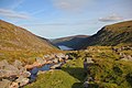
|
Glendalough Valley
|
NR
|
County Wicklow
|
Q691153
|
53°00′29″N 6°19′26″W / 53.008°N 6.324°W / 53.008; -6.324
|
| S.I. No. 69/1988
|
Glenealo Valley
|
|
yes
|
Glenealo Valley, Glendalough
|
NR
|
County Wicklow
|
Q104849570
|
53°00′40″N 6°23′24″W / 53.011°N 6.390°W / 53.011; -6.390
|
| S.I. No. 58/1994 IE0000725
|
Knocksink Wood
|
|
yes
|
Knocksink Wood
|
NR, SAC
|
County Wicklow
County Dublin
|
Q98106187
|
53°12′00″N 6°10′59″W / 53.200°N 6.183°W / 53.200; -6.183
|
| S.I. No. 374/1983
|
Vale of Clara
|
|
yes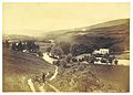
|
Vale of Clara
|
NR
|
County Wicklow
|
Q98380258
|
52°57′29″N 6°14′10″W / 52.958°N 6.236°W / 52.958; -6.236
|
| IE0000770
|
Blackstairs Mountains
|
|
yes
|
Blackstairs Mountains
|
SAC
|
County Carlow
County Wexford
|
Q601719
|
52°35′06″N 6°47′20″W / 52.585°N 6.789°W / 52.585; -6.789
|
| IE0002162
|
River Barrow
|
|
yes
|
River Barrow
|
SAC
|
Leinster
|
Q936301
|
52°34′55″N 7°10′59″W / 52.582°N 7.183°W / 52.582; -7.183
|
| IE0002162
|
River Nore
|
|
yes
|
River Nore
|
SAC
|
Leinster
|
Q1048506
|
52°34′55″N 7°10′59″W / 52.582°N 7.183°W / 52.582; -7.183
|
| IE0000781
|
Slaney River Valley
|
|
yes
|
River Slaney
|
SAC
|
County Carlow
County Wexford
County Wicklow
|
Q1122203
|
52°27′47″N 6°33′43″W / 52.463°N 6.562°W / 52.463; -6.562
|
| IE0002299
|
River Boyne
|
|
yes
|
River Boyne
|
SAC
|
Leinster
|
Q896037
|
53°41′38″N 6°47′06″W / 53.694°N 6.785°W / 53.694; -6.785
|
| IE0000713
|
Ballyman Glen
|
|
|
Ballyman Glen
|
SAC
|
County Dublin
County Wicklow
|
|
53°12′11″N 6°09′25″W / 53.203°N 6.157°W / 53.203; -6.157
|
| IE0000206
|
North Dublin Bay
|
|
yes
|
Dublin Bay
|
SAC, BIS
|
County Dublin
|
Q148621
|
53°22′08″N 6°08′10″W / 53.369°N 6.136°W / 53.369; -6.136
|
| IE0000210
|
South Dublin Bay
|
|
yes
|
Dublin Bay
|
SAC, BIS
|
County Dublin
|
Q148621
|
53°19′26″N 6°11′17″W / 53.324°N 6.188°W / 53.324; -6.188
|
| IE0001209
|
Glenasmole Valley
|
|
yes
|
Glenasmole Valley
|
SAC
|
County Dublin
|
Q109534170
|
53°14′31″N 6°21′47″W / 53.242°N 6.363°W / 53.242; -6.363
|
| IE0000202
|
Howth Head
|
|
yes
|
Howth Head
|
SAC
|
County Dublin
|
Q774374
|
53°22′26″N 6°03′54″W / 53.374°N 6.065°W / 53.374; -6.065
|
| IE0002193
|
Ireland's Eye
|
|
yes
|
Ireland's Eye
|
SAC
|
County Dublin
|
Q1672468
|
53°24′18″N 6°03′50″W / 53.405°N 6.064°W / 53.405; -6.064
|
| IE0000204
|
Lambay Island
|
|
yes
|
Lambay Island
|
SAC
|
County Dublin
|
Q1520062
|
53°29′28″N 6°00′50″W / 53.491°N 6.014°W / 53.491; -6.014
|
| IE0000205
|
Malahide Estuary
|
|
yes
|
Malahide Estuary
|
SAC
|
County Dublin
|
|
53°27′40″N 6°09′07″W / 53.461°N 6.152°W / 53.461; -6.152
|
| IE0000391
|
Ballynafagh Bog
|
|
|
Ballynafagh Bog
|
SAC
|
County Kildare
|
|
53°17′42″N 6°46′44″W / 53.295°N 6.779°W / 53.295; -6.779
|
| IE0001387
|
Ballynafagh Lake
|
|
|
Ballynafagh Lake
|
SAC
|
County Kildare
|
|
53°18′00″N 6°47′28″W / 53.300°N 6.791°W / 53.300; -6.791
|
| IE0000397
|
Red Bog, Kildare
|
|
|
Red Bog, County Kildare
|
SAC
|
County Kildare
|
|
53°11′49″N 6°32′06″W / 53.197°N 6.535°W / 53.197; -6.535
|
| IE0001398
|
Rye Water Valley/Carton
|
|
yes
|
River Rye
|
SAC
|
County Kildare
County Meath
|
Q7337795
|
53°22′48″N 6°32′13″W / 53.380°N 6.537°W / 53.380; -6.537
|
| IE0002331
|
Mouds Bog
|
|
|
Mouds Bog
|
SAC
|
County Kildare
|
|
53°12′54″N 6°49′01″W / 53.215°N 6.817°W / 53.215; -6.817
|
| IE0000404
|
Hugginstown Fen
|
|
|
Hugginstown Fen
|
SAC
|
County Kilkenny
|
|
52°25′34″N 7°13′59″W / 52.426°N 7.233°W / 52.426; -7.233
|
| IE0000407
|
The Loughans
|
|
|
The Loughans
|
SAC
|
County Kilkenny
|
|
52°43′26″N 7°32′02″W / 52.724°N 7.534°W / 52.724; -7.534
|
| IE0000831
|
Cullahill Mountain
|
|
|
Cullahill Mountain
|
SAC
|
County Kilkenny
|
Q28195275
|
52°47′24″N 7°29′20″W / 52.790°N 7.489°W / 52.790; -7.489
|
| IE0000849
|
Spahill and Clomantagh Hill
|
|
|
Spahill and Clomantagh Hill
|
SAC
|
County Kilkenny
|
Q5134932
|
52°44′53″N 7°30′25″W / 52.748°N 7.507°W / 52.748; -7.507
|
| IE0001858
|
Galmoy Fen
|
|
|
Galmoy Fen
|
SAC
|
County Kilkenny
|
|
52°48′29″N 7°34′08″W / 52.808°N 7.569°W / 52.808; -7.569
|
| IE0001858
|
Lower River Suir SAC
|
|
yes
|
Lower River Suir SAC
|
SAC
|
County Kilkenny
County Tipperary
County Waterford
|
|
52°23′53″N 7°38′06″W / 52.398°N 7.635°W / 52.398; -7.635
|
| IE0002252
|
Thomastown Quarry
|
|
|
Thomastown Quarry
|
SAC
|
County Kilkenny
|
|
52°32′06″N 7°08′38″W / 52.535°N 7.144°W / 52.535; -7.144
|
| IE0000859
|
Clonaslee Eskers and Derry Bog
|
|
|
Clonaslee Eskers and Derry Bog
|
SAC
|
County Laois
County Offaly
|
|
53°09′40″N 7°36′29″W / 53.161°N 7.608°W / 53.161; -7.608
|
| IE0002332
|
Coolrain Bog
|
|
|
Coolrain Bog
|
SAC
|
County Laois
|
|
52°58′23″N 7°36′00″W / 52.973°N 7.600°W / 52.973; -7.600
|
| IE0000869
|
Lisbigney Bog
|
|
|
Lisbigney Bog
|
SAC
|
County Laois
|
|
52°51′43″N 7°20′06″W / 52.862°N 7.335°W / 52.862; -7.335
|
| IE0002141
|
Mountmellick SAC
|
|
|
Mountmellick SAC
|
SAC
|
County Laois
|
|
53°07′37″N 7°15′58″W / 53.127°N 7.266°W / 53.127; -7.266
|
| IE0002333
|
Knockacollier Bog
|
|
|
Knockacollier Bog
|
SAC
|
County Laois
|
|
52°58′12″N 7°32′20″W / 52.970°N 7.539°W / 52.970; -7.539
|
| IE0002341
|
Ardagullion Bog
|
|
|
Ardagullion Bog
|
SAC
|
County Longford
|
|
53°43′34″N 7°31′26″W / 53.726°N 7.524°W / 53.726; -7.524
|
| IE0002346
|
Brown Bog
|
|
|
Brown Bog
|
SAC
|
County Longford
|
|
53°43′55″N 7°51′14″W / 53.732°N 7.854°W / 53.732; -7.854
|
| IE0002348
|
Clooneen Bog
|
|
|
Clooneen Bog
|
SAC
|
County Longford
|
|
53°48′11″N 7°53′46″W / 53.803°N 7.896°W / 53.803; -7.896
|
| IE0000448
|
Fortwilliam Turlough
|
|
|
Fortwilliam Turlough
|
SAC
|
County Longford
|
|
53°37′08″N 7°58′41″W / 53.619°N 7.978°W / 53.619; -7.978
|
| IE0001818
|
Lough Forbes Complex
|
|
|
Lough Forbes
|
SAC
|
County Longford
County Roscommon
|
Q24196541
|
53°45′54″N 7°52′41″W / 53.765°N 7.878°W / 53.765; -7.878
|
| IE0000440
|
Lough Ree
|
|
yes
|
Lough Ree
|
SAC
|
County Longford
County Roscommon
County Westmeath
|
Q608133
|
53°33′00″N 7°58′37″W / 53.550°N 7.977°W / 53.550; -7.977
|
| IE0002202
|
Mount Jessop Bog
|
|
|
Mount Jessop Bog
|
SAC
|
County Longford
|
|
53°40′41″N 7°48′11″W / 53.678°N 7.803°W / 53.678; -7.803
|
| IE0001957
|
Boyne Coast and Estuary
|
|
|
Boyne Coast and Estuary
|
SAC
|
County Louth
County Meath
|
|
53°43′44″N 6°15′29″W / 53.729°N 6.258°W / 53.729; -6.258
|
| IE0000453
|
Carlingford Mountain
|
|
yes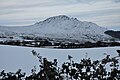
|
Slieve Foye
|
SAC
|
County Louth
|
Q7540435
|
54°03′32″N 6°16′16″W / 54.059°N 6.271°W / 54.059; -6.271
|
| IE0002306
|
Carlingford Shore
|
|
yes
|
Carlingford Shore
|
SAC
|
County Louth
|
Q112579673
|
54°02′02″N 6°09′47″W / 54.034°N 6.163°W / 54.034; -6.163
|
| IE0001459
|
Clogher Head
|
|
yes
|
Clogher Head
|
SAC
|
County Louth
|
Q26716062
|
53°47′35″N 6°13′16″W / 53.793°N 6.221°W / 53.793; -6.221
|
| IE0000455
|
Dundalk Bay
|
|
yes
|
Dundalk Bay
|
SAC, RS
|
County Louth
|
Q3633048
|
53°57′32″N 6°20′17″W / 53.959°N 6.338°W / 53.959; -6.338
|
| IE0002120
|
Lough Bane
|
|
yes
|
Lough Bane
|
SAC
|
County Meath
County Westmeath
|
Q1815595
|
53°41′17″N 7°10′23″W / 53.688°N 7.173°W / 53.688; -7.173
|
| IE0002120
|
Lough Glass
|
|
|
Lough Glass
|
SAC
|
County Meath
County Westmeath
|
Q33283353
|
53°41′17″N 7°10′23″W / 53.688°N 7.173°W / 53.688; -7.173
|
| IE0002340
|
Moneybeg Bogs and Clareisland Bogs
|
|
|
Moneybeg Bogs and Clareisland Bogs
|
SAC
|
County Meath
County Westmeath
|
|
53°46′55″N 7°20′02″W / 53.782°N 7.334°W / 53.782; -7.334
|
| IE0002342
|
Mount Hevey Bog
|
|
|
Mount Hevey Bog
|
SAC
|
County Meath
County Westmeath
|
|
53°28′41″N 7°04′01″W / 53.478°N 7.067°W / 53.478; -7.067
|
| IE0001810
|
White Lough, Ben Loughs and Lough Doo SAC
|
|
|
White Lough
|
SAC
|
County Meath
County Westmeath
|
Q33320705
|
53°42′00″N 7°12′58″W / 53.700°N 7.216°W / 53.700; -7.216
|
| IE0001810
|
White Lough, Ben Loughs and Lough Doo SAC
|
|
|
Ben Loughs
|
SAC
|
County Meath
County Westmeath
|
Q33230594
|
53°42′00″N 7°12′58″W / 53.700°N 7.216°W / 53.700; -7.216
|
| IE0001810
|
White Lough, Ben Loughs and Lough Doo SAC
|
|
|
Lough Doo
|
SAC
|
County Meath
County Westmeath
|
|
53°42′00″N 7°12′58″W / 53.700°N 7.216°W / 53.700; -7.216
|
| IE0000566
|
All Saints Bog and Esker
|
|
|
All Saints Bog and Esker
|
SAC
|
County Offaly
|
|
53°09′04″N 7°58′59″W / 53.151°N 7.983°W / 53.151; -7.983
|
| IE0000571
|
Charleville Wood
|
|
yes
|
Charleville Wood
|
SAC
|
County Offaly
|
|
53°15′36″N 7°31′26″W / 53.260°N 7.524°W / 53.260; -7.524
|
| IE0000575
|
Ferbane Bog
|
|
|
Ferbane Bog
|
SAC
|
County Offaly
|
|
53°17′02″N 7°50′10″W / 53.284°N 7.836°W / 53.284; -7.836
|
| IE0000576
|
Fin Lough
|
|
|
Fin Lough
|
SAC
|
County Offaly
|
|
53°18′54″N 7°57′04″W / 53.315°N 7.951°W / 53.315; -7.951
|
| IE0002236
|
Island Fen
|
|
|
Island Fen
|
SAC
|
County Offaly
|
|
53°03′47″N 7°49′08″W / 53.063°N 7.819°W / 53.063; -7.819
|
| IE0002147
|
Lisduff Fen
|
|
|
Lisduff Fen
|
SAC
|
County Offaly
|
|
53°03′14″N 7°52′41″W / 53.054°N 7.878°W / 53.054; -7.878
|
| IE0000581
|
Moyclare Bog
|
|
|
Moyclare Bog
|
SAC
|
County Offaly
|
|
53°16′05″N 7°53′02″W / 53.268°N 7.884°W / 53.268; -7.884
|
| IE0001776
|
Pilgrim's Road Esker
|
|
|
Pilgrim's Road Esker
|
SAC
|
County Offaly
|
|
53°19′59″N 7°56′35″W / 53.333°N 7.943°W / 53.333; -7.943
|
| IE0000216
|
River Shannon Callows
|
|
|
River Shannon Callows
|
SAC
|
Leinster
|
Q7488839
|
53°15′14″N 8°01′19″W / 53.254°N 8.022°W / 53.254; -8.022
|
| IE0000585
|
Sharavogue bog
|
|
|
Sharavogue bog
|
SAC
|
County Offaly
County Tipperary
|
|
53°02′10″N 7°55′48″W / 53.036°N 7.930°W / 53.036; -7.930
|
| IE0000925
|
The Long Derries
|
|
|
The Long Derries
|
SAC
|
County Offaly
|
|
53°18′40″N 7°00′14″W / 53.311°N 7.004°W / 53.311; -7.004
|
| IE0002313
|
Ballymore Fen
|
|
|
Ballymore Fen
|
SAC
|
County Westmeath
|
|
53°29′42″N 7°38′13″W / 53.495°N 7.637°W / 53.495; -7.637
|
| IE0002336
|
Carn Park Bog
|
|
|
Carn Park Bog
|
SAC
|
County Westmeath
|
|
53°25′34″N 7°49′37″W / 53.426°N 7.827°W / 53.426; -7.827
|
| IE0002337
|
Crosswood Bog
|
|
|
Crosswood Bog
|
SAC
|
County Westmeath
|
|
53°24′43″N 7°52′12″W / 53.412°N 7.870°W / 53.412; -7.870
|
| IE0000679
|
Garriskil Bog
|
|
|
Garriskil Bog
|
SAC
|
County Westmeath
|
|
53°39′22″N 7°27′11″W / 53.656°N 7.453°W / 53.656; -7.453
|
| IE0000685, 848
|
Lough Ennell
|
|
yes
|
Lough Ennell
|
SAC, RS
|
County Westmeath
|
Q2639357
|
53°28′01″N 7°24′14″W / 53.467°N 7.404°W / 53.467; -7.404
|
| IE0002121
|
Lough Lene
|
|
yes
|
Lough Lene
|
SAC
|
County Westmeath
|
Q1633096
|
53°39′47″N 7°13′44″W / 53.663°N 7.229°W / 53.663; -7.229
|
| IE0000688, 851
|
Lough Owel
|
|
yes
|
Lough Owel
|
SAC, RS
|
County Westmeath
|
Q2702889
|
53°34′23″N 7°23′35″W / 53.573°N 7.393°W / 53.573; -7.393
|
| IE0001831
|
Split Hills and Long Hill Esker
|
|
|
Split Hills and Long Hill Esker
|
SAC
|
County Westmeath
|
|
53°23′20″N 7°28′01″W / 53.389°N 7.467°W / 53.389; -7.467
|
| IE0000697, 840
|
Bannow Bay
|
|
yes
|
Bannow Bay
|
SAC, RS
|
County Wexford
|
Q26716368
|
52°13′59″N 6°47′42″W / 52.233°N 6.795°W / 52.233; -6.795
|
| IE0000700
|
Cahore Polders and Dunes
|
|
yes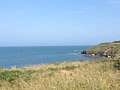
|
Cahore Polders and Dunes
|
SAC
|
County Wexford
|
|
52°32′35″N 6°12′50″W / 52.543°N 6.214°W / 52.543; -6.214
|
| IE0002269
|
Carnsore Point
|
|
yes
|
Carnsore Point
|
SAC
|
County Wexford
|
Q3495219
|
52°11′10″N 6°20′13″W / 52.186°N 6.337°W / 52.186; -6.337
|
| IE0000764
|
Hook Head
|
|
yes
|
Hook Head
|
SAC
|
County Wexford
|
Q1459722
|
52°06′11″N 6°52′30″W / 52.103°N 6.875°W / 52.103; -6.875
|
| IE0001741
|
Kilmuckridge-Tinnaberna Sandhills
|
|
yes
|
Kilmuckridge-Tinnaberna Sandhills
|
SAC
|
County Wexford
|
Q6408060
|
52°29′38″N 6°15′32″W / 52.494°N 6.259°W / 52.494; -6.259
|
| IE0001742
|
Kilpatrick Sandhills
|
|
|
Kilpatrick Sandhills
|
SAC
|
County Wexford
|
|
52°43′48″N 6°09′00″W / 52.730°N 6.150°W / 52.730; -6.150
|
| IE0000704
|
Lady's Island Lake
|
|
yes
|
Lady's Island Lake
|
SAC
|
County Wexford
|
Q6469864
|
52°11′38″N 6°23′35″W / 52.194°N 6.393°W / 52.194; -6.393
|
| IE0002161
|
Long Bank
|
|
|
Long Bank, County Wexford
|
SAC
|
County Wexford
|
Q26717460
|
52°18′00″N 6°16′55″W / 52.300°N 6.282°W / 52.300; -6.282
|
| IE0000707
|
Saltee Islands
|
|
yes
|
Saltee Islands
|
SAC
|
County Wexford
|
Q936626
|
52°07′05″N 6°35′53″W / 52.118°N 6.598°W / 52.118; -6.598
|
| IE0000708
|
Screen Hills
|
|
|
Screen Hills
|
SAC
|
County Wexford
|
|
52°24′25″N 6°23′20″W / 52.407°N 6.389°W / 52.407; -6.389
|
| IE0000709
|
Tacumshin Lake
|
|
|
Tacumshin Lake
|
SAC
|
County Wexford
|
Q26715337
|
52°11′49″N 6°28′05″W / 52.197°N 6.468°W / 52.197; -6.468
|
| IE0000714
|
Bray Head
|
|
yes
|
Bray Head
|
SAC
|
County Wicklow
|
Q902905
|
53°10′55″N 6°04′48″W / 53.182°N 6.080°W / 53.182; -6.080
|
| IE0000729
|
Buckroney-Brittas Dunes and Fen
|
|
|
Buckroney-Brittas Dunes and Fen
|
SAC
|
County Wicklow
|
|
52°52′01″N 6°04′34″W / 52.867°N 6.076°W / 52.867; -6.076
|
| IE0000716
|
Carriggower Bog
|
|
|
Carriggower Bog
|
SAC
|
County Wicklow
|
|
53°06′18″N 6°10′08″W / 53.105°N 6.169°W / 53.105; -6.169
|
| IE0000733
|
Rathdrum Wood
|
|
|
Rathdrum Wood
|
SAC
|
County Wicklow
|
|
52°57′22″N 6°14′10″W / 52.956°N 6.236°W / 52.956; -6.236
|
| IE0001757
|
Holdenstown Bog
|
|
|
Holdenstown Bog
|
SAC
|
County Wicklow
|
|
52°54′36″N 6°41′20″W / 52.910°N 6.689°W / 52.910; -6.689
|
| IE0001766
|
Magherabeg Dunes
|
|
|
Magherabeg Dunes
|
SAC
|
County Wicklow
|
|
52°55′23″N 6°01′52″W / 52.923°N 6.031°W / 52.923; -6.031
|
| IE0002249
|
The Murrough Wetlands
|
|
|
The Murrough Wetlands
|
SAC
|
County Wicklow
|
|
53°02′20″N 6°02′53″W / 53.039°N 6.048°W / 53.039; -6.048
|
| IE0002274
|
Wicklow Reef
|
|
|
Wicklow Reef
|
SAC
|
County Wicklow
|
|
52°58′26″N 5°57′25″W / 52.974°N 5.957°W / 52.974; -5.957
|
| 833
|
The Broadmeadow Estuary
|
|
yes
|
The Broadmeadow Estuary
|
RS
|
County Dublin
|
|
53°27′00″N 6°10′01″W / 53.450°N 6.167°W / 53.450; -6.167
|
| 847
|
Lough Derravaragh
|
|
yes
|
Lough Derravaragh
|
RS
|
County Westmeath
|
Q1586768
|
53°37′59″N 7°21′00″W / 53.633°N 7.350°W / 53.633; -7.350
|
| 849
|
Lough Glen
|
|
|
Lough Glen, County Westmeath
|
RS
|
County Westmeath
|
|
53°25′01″N 7°22′59″W / 53.417°N 7.383°W / 53.417; -7.383
|
| 850
|
Lough Iron
|
|
|
Lough Iron
|
RS
|
County Westmeath
|
Q6686126
|
53°37′01″N 7°16′59″W / 53.617°N 7.283°W / 53.617; -7.283
|
| 832
|
Sandymount Strand and Tolka Estuary
|
|
yes
|
Sandymount Strand
|
RS
|
County Dublin
|
Q7417543
|
53°19′59″N 6°12′00″W / 53.333°N 6.200°W / 53.333; -6.200
|
| 832
|
Sandymount Strand and Tolka Estuary
|
|
yes
|
Tolka Estuary
|
RS
|
County Dublin
|
Q107061307
|
53°21′36″N 6°13′30″W / 53.360°N 6.225°W / 53.360; -6.225
|


_p057_Vale_of_Clara.jpg)


_(32607943630).jpg)


.jpg)
_(33051773595).jpg)


.jpg)


