| №
|
Name
|
Upload
|
Photo
|
Category
|
Type[1]
|
Region(s)
|
Wikidata
|
Location
|
| IE0002356
|
Ardgraigue Bog
|

|
|
Ardgraigue Bog
|
SAC
|
County Galway
|
|
53°10′26″N 8°14′31″W / 53.174°N 8.242°W / 53.174; -8.242
|
| IE0002244
|
Ardrahan Grassland
|
|
|
Ardrahan Grassland
|
SAC
|
County Galway
|
|
53°09′54″N 8°49′52″W / 53.165°N 8.831°W / 53.165; -8.831
|
| IE0001228
|
Aughrusbeg Machair and Lake
|
|
|
Aughrusbeg Machair and Lake
|
SAC
|
County Galway
|
|
53°33′29″N 10°09′58″W / 53.558°N 10.166°W / 53.558; -10.166
|
| IE0002295
|
Ballinduff Turlough
|
|
|
Ballinduff Turlough
|
SAC
|
County Galway
|
|
53°07′12″N 8°48′25″W / 53.120°N 8.807°W / 53.120; -8.807
|
| IE0002118
|
Barnahallia Lough
|
|
|
Barnahallia Lough
|
SAC
|
County Galway
|
|
53°31′59″N 10°07′16″W / 53.533°N 10.121°W / 53.533; -10.121
|
| IE0000231
|
Barroughter Bog
|
|
|
Barroughter Bog
|
SAC
|
County Galway
|
|
53°04′44″N 8°18′40″W / 53.079°N 8.311°W / 53.079; -8.311
|
| IE0000238
|
Caherglassaun Turlough
|
|
|
Caherglassaun Turlough
|
SAC
|
County Galway
|
|
53°06′11″N 8°53′10″W / 53.103°N 8.886°W / 53.103; -8.886
|
| IE0002294
|
Cahermore Turlough
|
|
|
Cahermore Turlough
|
SAC
|
County Galway
|
|
53°07′05″N 8°52′26″W / 53.118°N 8.874°W / 53.118; -8.874
|
| IE0002347
|
Camderry Bog
|
|
|
Camderry Bog
|
SAC
|
County Galway
|
|
53°33′54″N 8°27′00″W / 53.565°N 8.450°W / 53.565; -8.450
|
| IE0002293
|
Carrowbaun, Newhall and Ballylee Turloughs
|
|
|
Carrowbaun, Newhall and Ballylee Turloughs
|
SAC
|
County Galway
|
|
53°06′32″N 8°46′59″W / 53.109°N 8.783°W / 53.109; -8.783
|
| IE0001242
|
Carrownagappul Bog
|
|
|
Carrownagappul Bog
|
SAC
|
County Galway
|
|
53°30′04″N 8°29′49″W / 53.501°N 8.497°W / 53.501; -8.497
|
| IE0000242
|
Castletaylor Complex
|
|
|
Castletaylor Complex
|
SAC
|
County Galway
|
|
53°11′06″N 8°49′01″W / 53.185°N 8.817°W / 53.185; -8.817
|
| IE0002034
|
Connemara Bog Complex
|
|
|
Connemara Bog Complex
|
SAC
|
County Galway
|
|
53°23′31″N 9°37′34″W / 53.392°N 9.626°W / 53.392; -9.626
|
| IE0001251
|
Cregduff Lough
|
|
|
Cregduff Lough
|
SAC
|
County Galway
|
|
53°23′13″N 9°55′34″W / 53.387°N 9.926°W / 53.387; -9.926
|
| IE0000255
|
Croaghill Turlough
|
|
|
Croaghill Turlough
|
SAC
|
County Galway
|
|
53°41′06″N 8°36′47″W / 53.685°N 8.613°W / 53.685; -8.613
|
| IE0002350
|
Curraghlehanagh Bog
|
|
|
Curraghlehanagh Bog
|
SAC
|
County Galway
|
|
53°31′48″N 8°29′28″W / 53.530°N 8.491°W / 53.530; -8.491
|
| IE0001257
|
Dog's Bay
|
|
yes
|
Dog's Bay
|
SAC
|
County Galway
|
Q98106298
|
53°22′30″N 9°57′43″W / 53.375°N 9.962°W / 53.375; -9.962
|
| IE0002181
|
Drummin Wood
|
|
|
Drummin Wood
|
SAC
|
County Galway
|
Q26718470
|
53°02′38″N 8°43′30″W / 53.044°N 8.725°W / 53.044; -8.725
|
| IE0002213
|
Glenloughaun Esker
|
|
|
Glenloughaun Esker
|
SAC
|
County Galway
|
|
53°17′35″N 8°15′54″W / 53.293°N 8.265°W / 53.293; -8.265
|
| IE0001271
|
Gortnandarragh Limestone Pavement
|
|
|
Gortnandarragh Limestone Pavement
|
SAC
|
County Galway
|
|
53°24′22″N 9°12′50″W / 53.406°N 9.214°W / 53.406; -9.214
|
| IE0000278
|
Inishbofin and Inishshark
|
|
yes
|
Inishbofin (Galway)
|
SAC
|
County Galway
|
Q1501256
|
53°37′01″N 10°13′26″W / 53.617°N 10.224°W / 53.617; -10.224
|
| IE0000278
|
Inishbofin and Inishshark
|
|
yes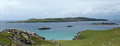
|
Inishark
|
SAC
|
County Galway
|
Q1558012
|
53°37′01″N 10°13′26″W / 53.617°N 10.224°W / 53.617; -10.224
|
| IE0001275
|
Inisheer Island
|
|
yes
|
Inisheer
|
SAC
|
County Galway
|
Q182941
|
53°03′22″N 9°31′48″W / 53.056°N 9.530°W / 53.056; -9.530
|
| IE0000212
|
Inishmaan Island
|
|
yes
|
Inishmaan
|
SAC
|
County Galway
|
Q1424587
|
53°04′55″N 9°35′31″W / 53.082°N 9.592°W / 53.082; -9.592
|
| IE0000213
|
Inishmore Island
|
|
yes
|
Inishmore
|
SAC
|
County Galway
|
Q369318
|
53°08′10″N 9°44′06″W / 53.136°N 9.735°W / 53.136; -9.735
|
| IE0002111
|
Kilkieran Bay and Islands
|
|
|
Kilkieran Bay and Islands
|
SAC
|
County Galway
|
|
53°16′52″N 9°43′48″W / 53.281°N 9.730°W / 53.281; -9.730
|
| IE0001285
|
Kiltiernan Turlough
|
|
|
Kiltiernan Turlough
|
SAC
|
County Galway
|
|
53°10′37″N 8°51′04″W / 53.177°N 8.851°W / 53.177; -8.851
|
| IE0002265
|
Kingstown Bay
|
|
|
Kingstown Bay
|
SAC
|
County Galway
|
|
53°30′58″N 10°07′37″W / 53.516°N 10.127°W / 53.516; -10.127
|
| IE0000295
|
Levally Lough
|
|
yes
|
Levally Lough
|
SAC
|
County Galway
|
Q33273029
|
53°31′44″N 8°42′36″W / 53.529°N 8.710°W / 53.529; -8.710
|
| IE0000296
|
Lisnageeragh Bog and Ballinastack Turlough
|
|
|
Lisnageeragh Bog and Ballinastack Turlough
|
SAC
|
County Galway
|
|
53°37′08″N 8°30′50″W / 53.619°N 8.514°W / 53.619; -8.514
|
| IE0001774
|
Lough Carra/Mask Complex
|
|
yes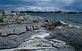
|
Lough Carra
|
SAC
|
County Galway
County Mayo
|
Q1871364
|
53°37′41″N 9°20′10″W / 53.628°N 9.336°W / 53.628; -9.336
|
| IE0001774
|
Lough Carra/Mask Complex
|
|
yes
|
Lough Mask
|
SAC
|
County Galway
County Mayo
|
Q1768048
|
53°37′41″N 9°20′10″W / 53.628°N 9.336°W / 53.628; -9.336
|
| IE0000297
|
Lough Corrib
|
|
yes
|
Lough Corrib
|
SAC
|
County Galway
County Mayo
County Roscommon
|
Q848917
|
53°26′06″N 9°10′12″W / 53.435°N 9.170°W / 53.435; -9.170
|
| IE0002117
|
Lough Coy
|
|
|
Lough Coy
|
SAC
|
County Galway
|
Q33282528
|
53°06′40″N 8°45′50″W / 53.111°N 8.764°W / 53.111; -8.764
|
| IE0000299
|
Lough Cutra
|
|
yes
|
Lough Cutra
|
SAC
|
County Galway
|
Q22084116
|
53°01′52″N 8°47′20″W / 53.031°N 8.789°W / 53.031; -8.789
|
| IE0000606
|
Lough Fingall Complex
|
|
|
Lough Fingall Complex
|
SAC
|
County Galway
|
Q33283161
|
53°10′59″N 8°52′59″W / 53.183°N 8.883°W / 53.183; -8.883
|
| IE0000301
|
Lough Lurgeen Bog/Glenamaddy Turlough
|
|
|
Lough Lurgeen Bog
|
SAC
|
County Galway
|
|
53°35′06″N 8°31′37″W / 53.585°N 8.527°W / 53.585; -8.527
|
| IE0000301
|
Lough Lurgeen Bog/Glenamaddy Turlough
|
|
yes
|
Glenamaddy Turlough
|
SAC
|
County Galway
|
Q5568140
|
53°35′06″N 8°31′37″W / 53.585°N 8.527°W / 53.585; -8.527
|
| IE0002119
|
Lough Nageeron
|
|
|
Lough Nageeron
|
SAC
|
County Galway
|
|
53°19′16″N 9°52′30″W / 53.321°N 9.875°W / 53.321; -9.875
|
| IE0000304
|
Lough Rea
|
|
yes
|
Lough Rea
|
SAC
|
County Galway
|
Q24196547
|
53°11′17″N 8°34′34″W / 53.188°N 8.576°W / 53.188; -8.576
|
| IE0002008
|
Maumturk Mountains
|
|
yes
|
Maumturk Mountains
|
SAC
|
County Galway
|
Q2639406
|
53°30′58″N 9°39′36″W / 53.516°N 9.660°W / 53.516; -9.660
|
| IE0002352
|
Monivea Bog
|
|
|
Monivea Bog
|
SAC
|
County Galway
|
|
53°21′43″N 8°40′52″W / 53.362°N 8.681°W / 53.362; -8.681
|
| IE0002129
|
Murvey Machair
|
|
|
Murvey Machair
|
SAC
|
County Galway
|
|
53°23′13″N 10°00′40″W / 53.387°N 10.011°W / 53.387; -10.011
|
| IE0001309
|
Omey Island Machair
|
|
|
Omey Island Machair
|
SAC
|
County Galway
|
|
53°32′02″N 10°09′47″W / 53.534°N 10.163°W / 53.534; -10.163
|
| IE0000318
|
Peterswell Turlough
|
|
|
Peterswell Turlough
|
SAC
|
County Galway
|
|
53°07′48″N 8°44′24″W / 53.130°N 8.740°W / 53.130; -8.740
|
| IE0004089
|
Rahasane Turlough
|
|
|
Rahasane Turlough
|
SAC
|
County Galway
|
Q7283312
|
53°13′16″N 8°47′10″W / 53.221°N 8.786°W / 53.221; -8.786
|
| IE0000324
|
Rosroe Bog
|
|
|
Rosroe Bog
|
SAC
|
County Galway
|
|
53°24′36″N 9°52′19″W / 53.410°N 9.872°W / 53.410; -9.872
|
| IE0001312
|
Ross Lake and Woods
|
|
|
Ross Lake and Woods
|
SAC
|
County Galway
|
|
53°22′34″N 9°13′08″W / 53.376°N 9.219°W / 53.376; -9.219
|
| IE0001313
|
Rosturra Wood
|
|
|
Rosturra Wood
|
SAC
|
County Galway
|
|
53°03′54″N 8°21′00″W / 53.065°N 8.350°W / 53.065; -8.350
|
| IE0001311
|
Rusheenduff Lough
|
|
|
Rusheenduff Lough
|
SAC
|
County Galway
|
|
53°36′29″N 10°00′25″W / 53.608°N 10.007°W / 53.608; -10.007
|
| IE0000326
|
Shankill West Bog
|
|
|
Shankill West Bog
|
SAC
|
County Galway
|
|
53°31′08″N 8°33′22″W / 53.519°N 8.556°W / 53.519; -8.556
|
| IE0000328
|
Slyne Head Islands
|
|
|
Slyne Head Islands
|
SAC
|
County Galway
|
|
53°25′30″N 10°11′46″W / 53.425°N 10.196°W / 53.425; -10.196
|
| IE0002074
|
Slyne Head Peninsula
|
|
|
Slyne Head Peninsula
|
SAC
|
County Galway
|
|
53°26′31″N 10°06′25″W / 53.442°N 10.107°W / 53.442; -10.107
|
| IE0001913
|
Sonnagh Bog
|
|
|
Sonnagh Bog
|
SAC
|
County Galway
|
|
53°07′30″N 8°38′42″W / 53.125°N 8.645°W / 53.125; -8.645
|
| IE0002031
|
The Twelve Bens/Garraun Complex
|
|
yes
|
Twelve Bens
|
SAC
|
County Galway
|
Q1093773
|
53°32′02″N 9°51′14″W / 53.534°N 9.854°W / 53.534; -9.854
|
| IE0002130
|
Tully Lough
|
|
yes
|
Tully Lough, Ballynahown, County Galway
|
SAC
|
County Galway
|
Q33317568
|
53°35′28″N 9°59′02″W / 53.591°N 9.984°W / 53.591; -9.984
|
| IE0000330
|
Tully Mountain
|
|
yes
|
Tully Mountain
|
SAC
|
County Galway
|
Q25240784
|
53°35′13″N 10°00′58″W / 53.587°N 10.016°W / 53.587; -10.016
|
| IE0002296
|
Williamstown Turloughs
|
|
|
Williamstown Turloughs
|
SAC
|
County Galway
|
|
53°39′43″N 8°39′00″W / 53.662°N 8.650°W / 53.662; -8.650
|
| IE0001403
|
Arroo Mountain
|
|
|
Arroo Mountain
|
SAC
|
County Leitrim
|
|
54°23′06″N 8°13′52″W / 54.385°N 8.231°W / 54.385; -8.231
|
| IE0000623
|
Ben Bulben, Gleniff and Glenade Complex
|
|
yes
|
Ben Bulben, Gleniff and Glenade Complex
|
SAC
|
County Leitrim
County Sligo
|
|
54°21′54″N 8°22′55″W / 54.365°N 8.382°W / 54.365; -8.382
|
| IE0002032
|
Boleybrack Mountain
|
|
|
Boleybrack Mountain
|
SAC
|
County Leitrim
County Cavan
|
|
54°14′49″N 8°04′05″W / 54.247°N 8.068°W / 54.247; -8.068
|
| IE0000625
|
Bunduff Lough and Machair/Trawalua/Mullaghmore
|
|
yes
|
Bunduff Lough
|
SAC
|
County Leitrim
County Sligo
|
Q33235299
|
54°27′58″N 8°26′56″W / 54.466°N 8.449°W / 54.466; -8.449
|
| IE0001919
|
Glenade Lough
|
|
yes
|
Glenade Lough
|
SAC
|
County Leitrim
|
Q24196274
|
54°21′54″N 8°16′16″W / 54.365°N 8.271°W / 54.365; -8.271
|
| IE0001976
|
Lough Gill
|
|
yes
|
Lough Gill
|
SAC
|
County Leitrim
County Sligo
|
Q1010499
|
54°15′43″N 8°20′28″W / 54.262°N 8.341°W / 54.262; -8.341
|
| IE0000428
|
Lough Melvin
|
|
yes
|
Lough Melvin
|
SAC
|
County Leitrim
County Donegal
|
Q3776146
|
54°25′59″N 8°11′06″W / 54.433°N 8.185°W / 54.433; -8.185
|
| IE0002268
|
Achill Head
|
|
yes
|
Achill Head
|
SAC
|
County Mayo
|
Q26716305
|
53°57′43″N 10°09′40″W / 53.962°N 10.161°W / 53.962; -10.161
|
| IE0000461
|
Ardkill Turlough
|
|
|
Ardkill Turlough
|
SAC
|
County Mayo
|
|
53°36′25″N 9°05′49″W / 53.607°N 9.097°W / 53.607; -9.097
|
| IE0000463
|
Balla Turlough
|
|
|
Balla Turlough
|
SAC
|
County Mayo
|
|
53°48′14″N 9°07′01″W / 53.804°N 9.117°W / 53.804; -9.117
|
| IE0001922
|
Bellacorick Bog Complex
|
|
|
Bellacorick Bog Complex
|
SAC
|
County Mayo
|
|
54°08′10″N 9°27′07″W / 54.136°N 9.452°W / 54.136; -9.452
|
| IE0000466
|
Bellacorick Iron Flush
|
|
|
Bellacorick Iron Flush
|
SAC
|
County Mayo
|
|
54°09′40″N 9°31′23″W / 54.161°N 9.523°W / 54.161; -9.523
|
| IE0002005
|
Bellacragher Saltmarsh
|
|
|
Bellacragher Saltmarsh
|
SAC
|
County Mayo
|
|
53°56′38″N 9°47′35″W / 53.944°N 9.793°W / 53.944; -9.793
|
| IE0000471
|
Brackloon Woods
|
|
yes
|
Brackloon Woods
|
SAC
|
County Mayo
|
|
53°45′36″N 9°33′36″W / 53.760°N 9.560°W / 53.760; -9.560
|
| IE0000472
|
Broadhaven Bay
|
|
yes
|
Broadhaven Bay
|
SAC
|
County Mayo
|
Q1089032
|
54°17′28″N 9°54′25″W / 54.291°N 9.907°W / 54.291; -9.907
|
| IE0000475
|
Carrowkeel Turlough
|
|
|
Carrowkeel Turlough
|
SAC
|
County Mayo
|
|
53°40′01″N 9°03′36″W / 53.667°N 9.060°W / 53.667; -9.060
|
| IE0000476
|
Carrowmore Lake Complex
|
|
yes
|
Carrowmore Lake
|
SAC
|
County Mayo
|
Q1045261
|
54°10′19″N 9°43′30″W / 54.172°N 9.725°W / 54.172; -9.725
|
| IE0002243
|
Clare Island Cliffs
|
|
|
Clare Island cliffs
|
SAC
|
County Mayo
|
|
53°48′22″N 10°01′08″W / 53.806°N 10.019°W / 53.806; -10.019
|
| IE0001482
|
Clew Bay Complex
|
|
|
Clew Bay Complex
|
SAC
|
County Mayo
|
|
53°51′07″N 9°39′11″W / 53.852°N 9.653°W / 53.852; -9.653
|
| IE0001899
|
Cloonakillina Lough
|
|
|
Cloonakillina Lough
|
SAC
|
County Mayo
|
Q33239899
|
54°00′14″N 8°37′30″W / 54.004°N 8.625°W / 54.004; -8.625
|
| IE0000479
|
Cloughmoyne
|
|
|
Cloughmoyne
|
SAC
|
County Mayo
|
|
53°29′28″N 9°10′23″W / 53.491°N 9.173°W / 53.491; -9.173
|
| IE0000480
|
Clyard Kettle-Holes
|
|
|
Clyard Kettle-Holes
|
SAC
|
County Mayo
|
|
53°34′52″N 9°10′44″W / 53.581°N 9.179°W / 53.581; -9.179
|
| IE0000485
|
Corraun Plateau
|
|
|
Corraun Plateau
|
SAC
|
County Mayo
|
|
53°53′38″N 9°51′32″W / 53.894°N 9.859°W / 53.894; -9.859
|
| IE0001955
|
Croaghaun/Slievemore
|
|
yes
|
Croaghaun
|
SAC
|
County Mayo
|
Q841068
|
53°59′42″N 10°08′10″W / 53.995°N 10.136°W / 53.995; -10.136
|
| IE0001955
|
Croaghaun/Slievemore
|
|
yes
|
Slievemore
|
SAC
|
County Mayo
|
Q1987191
|
53°59′42″N 10°08′10″W / 53.995°N 10.136°W / 53.995; -10.136
|
| IE0000484
|
Cross Lough (Killadoon)
|
|
yes
|
Cross Lough
|
SAC
|
County Mayo
|
Q22083934
|
53°42′18″N 9°54′36″W / 53.705°N 9.910°W / 53.705; -9.910
|
| IE0000492
|
Doocastle Turlough
|
|
|
Doocastle Turlough
|
SAC
|
County Mayo
County Sligo
|
|
54°01′37″N 8°38′28″W / 54.027°N 8.641°W / 54.027; -8.641
|
| IE0001497
|
Doogort Machair/Lough Doo
|
|
|
Doogort Machair
|
SAC
|
County Mayo
|
|
54°01′08″N 9°58′48″W / 54.019°N 9.980°W / 54.019; -9.980
|
| IE0001497
|
Doogort Machair/Lough Doo
|
|
|
Lough Doo
|
SAC
|
County Mayo
|
|
54°01′08″N 9°58′48″W / 54.019°N 9.980°W / 54.019; -9.980
|
| IE0000495
|
Duvillaun Islands
|
|
|
Duvillaun Islands
|
SAC
|
County Mayo
|
Q3776586
|
54°04′44″N 10°09′22″W / 54.079°N 10.156°W / 54.079; -10.156
|
| IE0001501
|
Erris Head
|
|
yes
|
Erris Head
|
SAC
|
County Mayo
|
Q2703868
|
54°16′52″N 10°02′28″W / 54.281°N 10.041°W / 54.281; -10.041
|
| IE0000497
|
Flughany Bog
|
|
|
Flughany Bog
|
SAC
|
County Mayo
County Sligo
|
|
54°00′32″N 8°35′28″W / 54.009°N 8.591°W / 54.009; -8.591
|
| IE0000500
|
Glenamoy Bog Complex
|
|
|
Glenamoy Bog Complex
|
SAC
|
County Mayo
|
|
54°16′48″N 9°38′35″W / 54.280°N 9.643°W / 54.280; -9.643
|
| IE0000503
|
Greaghans Turlough
|
|
|
Greaghans Turlough
|
SAC
|
County Mayo
|
|
53°36′36″N 9°04′30″W / 53.610°N 9.075°W / 53.610; -9.075
|
| IE0000507
|
Inishkea Islands
|
|
yes
|
Inishkea Islands
|
SAC
|
County Mayo
|
Q841031
|
54°07′48″N 10°12′22″W / 54.130°N 10.206°W / 54.130; -10.206
|
| IE0001513
|
Keel Machair/Menaun Cliffs
|
|
|
Keel Machair
|
SAC
|
County Mayo
|
|
53°57′18″N 10°02′13″W / 53.955°N 10.037°W / 53.955; -10.037
|
| IE0001513
|
Keel Machair/Menaun Cliffs
|
|
yes
|
Menawn Cliffs
|
SAC
|
County Mayo
|
Q26715519
|
53°57′18″N 10°02′13″W / 53.955°N 10.037°W / 53.955; -10.037
|
| IE0000504
|
Kilglassan/Caheravoostia Turlough Complex
|
|
|
Kilglassan/Caheravoostia Turlough Complex
|
SAC
|
County Mayo
|
|
53°37′30″N 9°05′42″W / 53.625°N 9.095°W / 53.625; -9.095
|
| IE0000516
|
Lackan Saltmarsh and Kilcummin Head
|
|
|
Lackan Saltmarsh and Kilcummin Head
|
SAC
|
County Mayo
|
|
54°16′37″N 9°14′35″W / 54.277°N 9.243°W / 54.277; -9.243
|
| IE0001529
|
Lough Cahasy, Lough Baun and Roonah Lough
|
|
|
Lough Cahasy
|
SAC
|
County Mayo
|
Q33282278
|
53°43′59″N 9°53′42″W / 53.733°N 9.895°W / 53.733; -9.895
|
| IE0001529
|
Lough Cahasy, Lough Baun and Roonah Lough
|
|
|
Lough Baun
|
SAC
|
County Mayo
|
Q33282039
|
53°43′59″N 9°53′42″W / 53.733°N 9.895°W / 53.733; -9.895
|
| IE0001529
|
Lough Cahasy, Lough Baun and Roonah Lough
|
|
|
Roonah Lough
|
SAC
|
County Mayo
|
Q33303315
|
53°43′59″N 9°53′42″W / 53.733°N 9.895°W / 53.733; -9.895
|
| IE0000522
|
Lough Gall Bog
|
|
|
Lough Gall Bog
|
SAC
|
County Mayo
|
|
53°56′24″N 9°48′40″W / 53.940°N 9.811°W / 53.940; -9.811
|
| IE0000633
|
Lough Hoe Bog
|
|
|
Lough Hoe Bog
|
SAC
|
County Mayo
County Sligo
|
|
54°03′58″N 8°58′44″W / 54.066°N 8.979°W / 54.066; -8.979
|
| IE0001536
|
Mocorha Lough
|
|
|
Mocorha Lough
|
SAC
|
County Mayo
|
|
53°32′24″N 9°09′47″W / 53.540°N 9.163°W / 53.540; -9.163
|
| IE0000470
|
Mullet/Blacksod Bay Complex
|
|
|
Mullet Bay, County Mayo
|
SAC
|
County Mayo
|
|
54°08′46″N 10°00′58″W / 54.146°N 10.016°W / 54.146; -10.016
|
| IE0000470
|
Mullet/Blacksod Bay Complex
|
|
yes
|
Blacksod Bay
|
SAC
|
County Mayo
|
Q515309
|
54°08′46″N 10°00′58″W / 54.146°N 10.016°W / 54.146; -10.016
|
| IE0001932
|
Mweelrea/Sheeffry/Erriff Complex
|
|
yes
|
Mweelrea Mountains
|
SAC
|
County Mayo
|
Q1956300
|
53°40′01″N 9°42′25″W / 53.667°N 9.707°W / 53.667; -9.707
|
| IE0001932
|
Mweelrea/Sheeffry/Erriff Complex
|
|
yes
|
Sheeffry Hills
|
SAC
|
County Mayo
|
Q7492326
|
53°40′01″N 9°42′25″W / 53.667°N 9.707°W / 53.667; -9.707
|
| IE0001932
|
Mweelrea/Sheeffry/Erriff Complex
|
|
yes
|
Erriff River
|
SAC
|
County Mayo
|
Q28232563
|
53°40′01″N 9°42′25″W / 53.667°N 9.707°W / 53.667; -9.707
|
| IE0002144
|
Newport River
|
|
yes
|
Newport River, County Mayo
|
SAC
|
County Mayo
|
|
53°55′34″N 9°25′48″W / 53.926°N 9.430°W / 53.926; -9.430
|
| IE0000534
|
Owenduff/Nephin Complex
|
|
|
Owenduff River
|
SAC
|
County Mayo
|
|
54°01′01″N 9°41′38″W / 54.017°N 9.694°W / 54.017; -9.694
|
| IE0000534
|
Owenduff/Nephin Complex
|
|
yes
|
Nephin
|
SAC
|
County Mayo
|
Q1650901
|
54°01′01″N 9°41′38″W / 54.017°N 9.694°W / 54.017; -9.694
|
| IE0002006
|
Ox Mountains Bogs
|
|
|
Ox Mountains Bogs
|
SAC
|
County Mayo
County Sligo
|
|
54°09′04″N 8°50′28″W / 54.151°N 8.841°W / 54.151; -8.841
|
| IE0000525
|
Shrule Turlough
|
|
|
Shrule Turlough
|
SAC
|
County Mayo
|
|
53°31′59″N 9°06′47″W / 53.533°N 9.113°W / 53.533; -9.113
|
| IE0000541
|
Skealoghan Turlough
|
|
|
Skealoghan Turlough
|
SAC
|
County Mayo
|
|
53°36′32″N 9°08′28″W / 53.609°N 9.141°W / 53.609; -9.141
|
| IE0000542
|
Slieve Fyagh Bog
|
|
|
Slieve Fyagh Bog
|
SAC
|
County Mayo
|
|
54°12′25″N 9°40′23″W / 54.207°N 9.673°W / 54.207; -9.673
|
| IE0001571
|
Urlaur Lakes
|
|
yes
|
Urlaur Lakes
|
SAC
|
County Mayo
County Roscommon
|
|
53°51′00″N 8°45′04″W / 53.850°N 8.751°W / 53.850; -8.751
|
| IE0001626
|
Annaghmore Lough
|
|
|
Annaghmore Lough
|
SAC
|
County Roscommon
|
Q24196675
|
53°47′49″N 8°08′24″W / 53.797°N 8.140°W / 53.797; -8.140
|
| IE0000588
|
Ballinturly Turlough
|
|
|
Ballinturly Turlough
|
SAC
|
County Roscommon
|
|
53°35′17″N 8°14′42″W / 53.588°N 8.245°W / 53.588; -8.245
|
| IE0002339
|
Ballynamona Bog and Corkip Lough
|
|
yes
|
Ballynamona Bog
|
SAC
|
County Roscommon
|
|
53°26′17″N 8°05′38″W / 53.438°N 8.094°W / 53.438; -8.094
|
| IE0002339
|
Ballynamona Bog and Corkip Lough
|
|
|
Corkip Lough
|
SAC
|
County Roscommon
|
|
53°26′17″N 8°05′38″W / 53.438°N 8.094°W / 53.438; -8.094
|
| IE0004105
|
Bellanagare Bog
|
|
|
Bellanagare Bog
|
SAC
|
County Roscommon
|
|
53°49′37″N 8°26′13″W / 53.827°N 8.437°W / 53.827; -8.437
|
| IE0000595
|
Callow Bog
|
|
|
Callow Bog
|
SAC
|
County Roscommon
|
|
53°54′36″N 8°30′00″W / 53.910°N 8.500°W / 53.910; -8.500
|
| IE0000597
|
Carrowbehy/Caher Bog
|
|
|
Carrowbehy/Caher Bog
|
SAC
|
County Roscommon
|
|
53°47′38″N 8°39′07″W / 53.794°N 8.652°W / 53.794; -8.652
|
| IE0001625
|
Castlesampson Esker
|
|
|
Castlesampson Esker
|
SAC
|
County Roscommon
|
|
53°24′40″N 8°06′32″W / 53.411°N 8.109°W / 53.411; -8.109
|
| IE0000600
|
Cloonchambers Bog
|
|
|
Cloonchambers Bog
|
SAC
|
County Roscommon
|
|
53°46′12″N 8°33′54″W / 53.770°N 8.565°W / 53.770; -8.565
|
| IE0000614
|
Cloonshanville Bog
|
|
|
Cloonshanville Bog
|
SAC
|
County Roscommon
|
|
53°52′23″N 8°22′41″W / 53.873°N 8.378°W / 53.873; -8.378
|
| IE0000218
|
Coolcam Turlough
|
|
|
Coolcam Turlough
|
SAC
|
County Roscommon
|
|
53°41′13″N 8°38′31″W / 53.687°N 8.642°W / 53.687; -8.642
|
| IE0002349
|
Corbo Bog
|
|
|
Corbo Bog
|
SAC
|
County Roscommon
|
|
53°40′08″N 8°05′10″W / 53.669°N 8.086°W / 53.669; -8.086
|
| IE0002110
|
Corliskea/Trien/Cloonfelliv Bog
|
|
|
Corliskea/Trien/Cloonfelliv Bog
|
SAC
|
County Roscommon
|
|
53°43′05″N 8°30′25″W / 53.718°N 8.507°W / 53.718; -8.507
|
| IE0000604
|
Derrinea Bog
|
|
|
Derrinea Bog
|
SAC
|
County Roscommon
|
|
53°50′35″N 8°41′31″W / 53.843°N 8.692°W / 53.843; -8.692
|
| IE0002338
|
Drumalough Bog
|
|
|
Drumalough Bog
|
SAC
|
County Roscommon
|
|
53°47′49″N 8°35′35″W / 53.797°N 8.593°W / 53.797; -8.593
|
| IE0000607
|
Errit Lough
|
|
|
Errit Lough
|
SAC
|
County Roscommon
|
Q24196679
|
53°48′50″N 8°42′00″W / 53.814°N 8.700°W / 53.814; -8.700
|
| IE0001637
|
Four Roads Turlough
|
|
|
Four Roads Turlough
|
SAC
|
County Roscommon
|
|
53°30′43″N 8°14′28″W / 53.512°N 8.241°W / 53.512; -8.241
|
| IE0000609
|
Lisduff Turlough
|
|
|
Lisduff Turlough
|
SAC
|
County Roscommon
|
|
53°33′00″N 8°14′28″W / 53.550°N 8.241°W / 53.550; -8.241
|
| IE0001673
|
Lough Arrow
|
|
yes
|
Lough Arrow
|
SAC
|
County Roscommon
County Sligo
|
Q1871350
|
54°03′29″N 8°19′19″W / 54.058°N 8.322°W / 54.058; -8.322
|
| IE0004139
|
Lough Croan Turlough
|
|
|
Lough Croan
|
SAC
|
County Roscommon
|
Q33282560
|
53°29′42″N 8°10′52″W / 53.495°N 8.181°W / 53.495; -8.181
|
| IE0000611
|
Lough Funshinagh
|
|
yes
|
Lough Funshinagh
|
SAC
|
County Roscommon
|
Q24196537
|
53°30′43″N 8°06′11″W / 53.512°N 8.103°W / 53.512; -8.103
|
| IE0000612
|
Mullygollan Turlough
|
|
|
Mullygollan Turlough
|
SAC
|
County Roscommon
|
|
53°45′50″N 8°18′22″W / 53.764°N 8.306°W / 53.764; -8.306
|
| IE0002298
|
River Moy
|
|
yes
|
River Moy
|
SAC
|
County Roscommon
County Mayo
County Sligo
|
|
53°59′20″N 9°06′47″W / 53.989°N 9.113°W / 53.989; -9.113
|
| IE0002354
|
Tullaghanrock Bog
|
|
|
Tullaghanrock Bog
|
SAC
|
County Roscommon
|
|
53°54′40″N 8°31′52″W / 53.911°N 8.531°W / 53.911; -8.531
|
| IE0000622
|
Ballysadare Bay
|
|
yes
|
Ballysadare Bay
|
SAC, SPA
|
County Sligo
|
Q26716363
|
54°14′10″N 8°35′20″W / 54.236°N 8.589°W / 54.236; -8.589
|
| IE0001656
|
Bricklieve Mountains and Keishcorran
|
|
yes
|
Bricklieve Mountains
|
SAC
|
County Sligo
|
Q26717911
|
54°02′56″N 8°23′31″W / 54.049°N 8.392°W / 54.049; -8.392
|
| IE0001656
|
Bricklieve Mountains and Keishcorran
|
|
|
Keishcorran
|
SAC
|
County Sligo
|
Q26715902
|
54°02′56″N 8°23′31″W / 54.049°N 8.392°W / 54.049; -8.392
|
| IE0000627
|
Cummeen Strand/Drumcliff Bay
|
|
|
Cummeen Strand
|
SAC
|
County Sligo
|
|
54°19′19″N 8°34′59″W / 54.322°N 8.583°W / 54.322; -8.583
|
| IE0000627
|
Cummeen Strand/Drumcliff Bay
|
|
yes
|
Drumcliff Bay
|
SAC
|
County Sligo
|
Q26716174
|
54°19′19″N 8°34′59″W / 54.322°N 8.583°W / 54.322; -8.583
|
| IE0000458
|
Killala Bay/Moy Estuary
|
|
yes
|
Killala Bay
|
SAC
|
County Sligo
County Mayo
|
Q944964
|
54°12′18″N 9°09′50″W / 54.205°N 9.164°W / 54.205; -9.164
|
| IE0001669
|
Knockalongy and Knockachree Cliffs
|
|
yes
|
Knockalongy
|
SAC
|
County Sligo
|
Q6422817
|
54°12′22″N 8°44′20″W / 54.206°N 8.739°W / 54.206; -8.739
|
| IE0001669
|
Knockalongy and Knockachree Cliffs
|
|
|
Knockachree Cliffs
|
SAC
|
County Sligo
|
|
54°12′22″N 8°44′20″W / 54.206°N 8.739°W / 54.206; -8.739
|
| IE0000634
|
Lough Nabrickkeagh Bog
|
|
|
Lough Nabrickkeagh Bog
|
SAC
|
County Sligo
|
|
54°04′59″N 8°53′28″W / 54.083°N 8.891°W / 54.083; -8.891
|
| IE0001680
|
Streedagh Point Dunes
|
|
yes
|
Streedagh Point Dunes
|
SAC
|
County Sligo
|
|
54°24′36″N 8°32′02″W / 54.410°N 8.534°W / 54.410; -8.534
|
| IE0000636
|
Templehouse and Cloonacleigha Loughs
|
|
yes
|
Templehouse Lough
|
SAC
|
County Sligo
|
Q24196288
|
54°05′49″N 8°35′28″W / 54.097°N 8.591°W / 54.097; -8.591
|
| IE0000636
|
Templehouse and Cloonacleigha Loughs
|
|
yes
|
Cloonacleigha Lough
|
SAC
|
County Sligo
|
Q24196603
|
54°05′49″N 8°35′28″W / 54.097°N 8.591°W / 54.097; -8.591
|
| IE0000637
|
Turloughmore
|
|
|
Turloughmore (lake)
|
SAC
|
County Sligo
|
|
54°04′01″N 8°41′35″W / 54.067°N 8.693°W / 54.067; -8.693
|
| IE0000638
|
Union Wood
|
|
|
Union Wood
|
SAC
|
County Sligo
|
Q26717895
|
54°12′11″N 8°29′17″W / 54.203°N 8.488°W / 54.203; -8.488
|
| IE0001898
|
Unshin River
|
|
|
Unshin River
|
SAC
|
County Sligo
|
|
54°09′36″N 8°28′05″W / 54.160°N 8.468°W / 54.160; -8.468
|


_-_geograph.org.uk_-_1295616.jpg)

.jpg)


.jpg)


_(32607943630).jpg)


.jpg)
_(33051773595).jpg)


.jpg)


.jpg)


.jpg)


_-_geograph.org.uk_-_1773972.jpg)


.jpg)


.jpeg)
.jpg)


