Category:Utah State Route 139
Jump to navigation
Jump to search
 | number: | (one hundred thirty-nine) |
|---|---|---|
| State highways in Utah: | 119 · 120 · 121 · 122 · 123 · 124 · 125 · 126 · 127 · 128 · 129 · 130 · 131 · 132 · 133 · 134 · 135 · 136 · 137 · 138 · 139 · 140 · 141 · 142 · 143 · 144 · 145 · 146 · 147 · 148 · 149 · 150 · 151 · 152 · 153 · 154 · 155 · 156 · 157 · 158 · 159 |
state highway in Carbon County, Utah, United States  | |||||
| Upload media | |||||
| Instance of | |||||
|---|---|---|---|---|---|
| Location | Carbon County, Utah | ||||
| Transport network | |||||
| Owned by |
| ||||
| Maintained by | |||||
| Inception |
| ||||
| Length |
| ||||
| Terminus |
| ||||
 | |||||
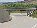
English: Media related to Utah State Route 139 (SR-139), also known as North Spring Glen Road, a 1.4187-mile (2.2832 km) state highway in northwestern Carbon County, Utah, United States, that connects U.S. Route 6 / U.S. Route 191 (US 6 / US 191), just southwest of Spring Glen, with Utah State Route 157 (Kenilworth Road) on the north side of Spring Glen.
From 1933 to 1977 the western terminus of SR-139 was at Consumers and from 1933 to 1969 the eastern terminus was at Utah State Route 27, later also designated as US 6 / U.S. Route 50, (at the intersection of West 3500 North and North Spring Glenn Drive, northeast of its current southern terminus).
From 1933 to 1977 the western terminus of SR-139 was at Consumers and from 1933 to 1969 the eastern terminus was at Utah State Route 27, later also designated as US 6 / U.S. Route 50, (at the intersection of West 3500 North and North Spring Glenn Drive, northeast of its current southern terminus).
Subcategories
This category has only the following subcategory.
Media in category "Utah State Route 139"
The following 10 files are in this category, out of 10 total.
-
 East at junction of US 6 & US 191 with SR-139, May 17.jpg 2,592 × 1,944; 2.36 MB
-
 East at SR-139 & SR-157 junction, May 17.jpg 2,592 × 1,944; 2.42 MB
-
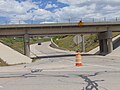
 North at junction of US 6 & US 191 with SR-139, May 17.jpg 2,592 × 1,944; 2.39 MB
-
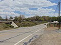
 North at SR-139 & SR-157 junction, May 17.jpg 2,592 × 1,944; 2.44 MB
-
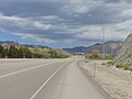
 South at junction of US 6 & US 191 with SR-139, May 17.jpg 2,592 × 1,944; 2.26 MB
-
 South at SR-139 & SR-157 junction, May 17.jpg 2,592 × 1,944; 2.43 MB
-
 Utah 139.svg 750 × 600; 73 KB
-
 Utah SR 139.svg 385 × 385; 9 KB
-
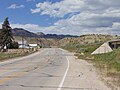
 West at junction of US 6 & US 191 with SR-139, May 17.jpg 2,592 × 1,944; 2.36 MB
-
 West at SR-139 & SR-157 junction, May 17.jpg 2,592 × 1,944; 2.38 MB


