Category:Utah State Route 103
Jump to navigation
Jump to search
 | number: | (one hundred three) |
|---|---|---|
| State highways in Utah: | 83 · 84 · 85 · 86 · 87 · 88 · 89 · 90 · 91 · 92 · 93 · 94 · 95 · 96 · 97 · 98 · 99 · 100 · 101 · 102 · 103 · 104 · 105 · 106 · 107 · 108 · 109 · 110 · 111 · 112 · 113 · 114 · 115 · 116 · 117 · 118 · 119 · 120 · 121 · 122 · 123 |
state highway in Clearfield, Utah, United States   | |||||
| Upload media | |||||
| Instance of | |||||
|---|---|---|---|---|---|
| Location | Clearfield, Davis County, Utah | ||||
| Transport network | |||||
| Connects with | |||||
| Owned by | |||||
| Maintained by | |||||
| Inception |
| ||||
| Length |
| ||||
| Terminus | |||||
| |||||
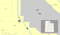
English: Media related to Utah State Route 103, a 0.225-mile (0.362 km) state highway on the northern edge of Clearfield, Utah, United States, that connects Utah State Route 126 (North Main Street) with the Falcon Hill National Aerospace Research Park (just west the West Gate of the Hill Air Force Base), with an interchange with Interstate 15 along the way. (For over fifty years, prior to the establishment of Utah State 231 in 2018, it was the shortest state highway in Utah that did not serve a state park or other state institution.)
Subcategories
This category has only the following subcategory.
Media in category "Utah State Route 103"
The following 6 files are in this category, out of 6 total.
-
 Northbound I-15 at UT-103 - 650 North.jpg 3,400 × 2,240; 1.21 MB
-
 UT 103 in Ogden, 1954.PNG 613 × 447; 171 KB
-
 Utah 103.svg 750 × 600; 73 KB
-
 Utah Route 103 map.png 1,138 × 852; 35 KB
-
 Utah SR 103 map.svg 1,475 × 860; 317 KB
-
 Utah SR 103.svg 385 × 385; 10 KB


