Category:SVG maps of Wyoming
Jump to navigation
Jump to search
States of the United States: Alabama · Alaska · Arizona · Arkansas · California · Colorado · Connecticut · Delaware · Florida · Georgia · Hawaii · Idaho · Illinois · Indiana · Iowa · Kansas · Kentucky · Louisiana · Maine · Maryland · Massachusetts · Michigan · Minnesota · Mississippi · Missouri · Montana · Nebraska · Nevada · New Hampshire · New Jersey · New Mexico · New York · North Carolina · North Dakota · Ohio · Oklahoma · Oregon · Pennsylvania · Rhode Island · South Carolina · South Dakota · Tennessee · Texas · Utah · Vermont · Virginia · Washington · West Virginia · Wisconsin · Wyoming – Washington, D.C.
American Samoa · Guam · Northern Mariana Islands · Puerto Rico – Navassa Island · Palmyra Atoll
American Samoa · Guam · Northern Mariana Islands · Puerto Rico – Navassa Island · Palmyra Atoll
A collection of maps of Wyoming or portions thereof in SVG format.
Subcategories
This category has only the following subcategory.
Media in category "SVG maps of Wyoming"
The following 33 files are in this category, out of 33 total.
-
 2014 Wyoming gubernatorial election results map by county.svg 810 × 624; 15 KB
-
 2018 Wyoming House of Representatives election results map.svg 1,200 × 940; 359 KB
-
 2020 Wyoming House of Representatives election results map.svg 1,200 × 940; 359 KB
-
 2022 Wyoming House of Representatives election results map.svg 1,200 × 940; 581 KB
-
 2022 Wyoming House of Representatives election results with margins.svg 3,062 × 1,693; 625 KB
-
 41st parallel US.svg 959 × 593; 66 KB
-
 45th parallel US-as.svg 959 × 593; 66 KB
-
 45th parallel US-bn.svg 959 × 593; 66 KB
-
 45th parallel US.svg 959 × 593; 66 KB
-
 Blank Map of Wyoming, with counties labeled and labels for values.svg 5,892 × 4,514; 67 KB
-
 COVID-19 in Wyoming.svg 512 × 392; 32 KB
-
 Front Range Urban Corridor.svg 723 × 843; 265 KB
-
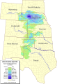
 High plains fresh groundwater usage 2000.svg 747 × 946; 1.48 MB
-
 I-25 Wyoming-1.svg 325 × 1,120; 139 KB
-
 I-25 Wyoming-2.svg 325 × 813; 71 KB
-
 I-25 Wyoming-full.svg 1,903 × 3,495; 478 KB
-
 LGBT flag map of Wyoming.svg 5,883 × 4,500; 5 KB
-
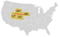
 Map of USA WY.svg 286 × 186; 167 KB
-
 Ogallala saturated thickness 1997-sattk97-v2.svg 656 × 960; 1.36 MB
-

-

-
 Wyoming counties by race.svg 221 × 183; 22 KB
-
 Wyoming county map, cb 500k.svg 810 × 624; 12 KB
-
 Wyoming Hispanic population percentage by county.svg 627 × 480; 30 KB
-
 Wyoming House 2022 retirements.svg 1,200 × 940; 581 KB
-
 Wyoming House of Representatives districts party map, 66th Legislature.svg 1,200 × 940; 361 KB
-
 Wyoming House of Representatives districts party map, 67th Legislature.svg 1,200 × 940; 581 KB
-
 Wyoming Köppen.svg 1,260 × 1,305; 798 KB
-
 Wyoming Locator Map with US.svg 2,102 × 2,045; 364 KB
-
 Wyoming map of Köppen climate classification.svg 1,900 × 1,305; 118 KB
-
 Wyoming racial and ethnic map.svg 221 × 183; 20 KB
-
 Wyoming state senate Map Current.svg 800 × 459; 1.68 MB
-
 Wyoming Toad current range map.svg 512 × 392; 87 KB


