Category:RAF Andrews Field
Jump to navigation
Jump to search
English: RAF Andrews Field near Great Saling, Essex, was used by the RAF and USAAF until the end of World War II. For civilian aviation use since 1946 see Category:Andrewsfield Airport.
| Object location | | View all coordinates using: OpenStreetMap |
|---|
former Air Force field located in England  | |||||
| Upload media | |||||
| Instance of |
| ||||
|---|---|---|---|---|---|
| Location |
| ||||
| Operator |
| ||||
| Inception |
| ||||
| Dissolved, abolished or demolished date |
| ||||
| Replaced by | |||||
 | |||||
Subcategories
This category has only the following subcategory.
Media in category "RAF Andrews Field"
The following 25 files are in this category, out of 25 total.
-
 1st Pathfinder Squadron - Crew Photo.jpg 640 × 508; 74 KB
-
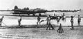
 322d Bomb Group B-26 Marauder 41-31773 (cropped).jpg 1,170 × 659; 168 KB
-
 322d Bomb Group B-26 Marauder 41-31773.jpg 1,303 × 872; 244 KB
-
 322dbg-b26.jpg 600 × 463; 59 KB
-
 95bg-b17andrews.jpg 600 × 280; 42 KB
-

-

-

-

-
 Andrewsfieldphoto-26jul48.png 600 × 493; 352 KB
-
 B-26-322bg-andfld-1944.jpg 1,267 × 867; 282 KB
-
 Grodynski Brigade Image 17.jpg 1,697 × 1,136; 210 KB
-
 RAF Andrews Field - 3 July 1949 5372.jpg 1,668 × 1,726; 614 KB
-
 RAF Andrews Field - 3 July 1949 5373.jpg 1,662 × 1,729; 600 KB
-
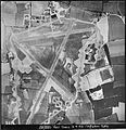 RAF Andrews Field - 3 July 1949 5412.jpg 1,670 × 1,722; 550 KB
-
 RAF Andrews Field - 3 July 1949 5419.jpg 1,666 × 1,734; 574 KB
-
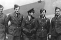
 RAF Andrews Field - 322d Bombardment Group - 3 Airmen.jpg 1,316 × 866; 232 KB
-
 RAF Andrews Field - 322d Bombardment Group - B-26 Marauder 41-31814 2.jpg 1,312 × 861; 201 KB
-
 RAF Andrews Field - 322d Bombardment Group - B-26 Marauder 41-31814.jpg 1,318 × 862; 193 KB
-
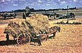 RAF Andrews Field - 322d Bombardment Group - Farmers.jpg 1,273 × 828; 532 KB
-
 RAF Andrews Field - 4 September 1943 - Airfield.jpg 1,704 × 1,350; 439 KB
-
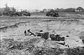 RAF Andrews Field - Construction Photo.jpg 5,486 × 3,597; 2.44 MB
-
 Andrews Field Hangar^ - geograph.org.uk - 570307.jpg 640 × 426; 108 KB
-
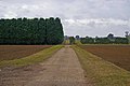 Andrews Field Peri - geograph.org.uk - 577168.jpg 640 × 426; 95 KB
-


.jpg)


