Category:Old maps of the Sinai Peninsula
Jump to navigation
Jump to search
Subcategories
This category has the following 3 subcategories, out of 3 total.
P
- Ptolemy's 4th Asian Map (73 F)
Media in category "Old maps of the Sinai Peninsula"
The following 79 files are in this category, out of 79 total.
-
 Tabula Rogeriana Muhammad al-Idrisi map of Syria, Palestine, Sinai.png 1,440 × 837; 1.82 MB
-
 Arabiae Petraeae descriptio ex observatione Ziegleri - btv1b5963523z (1 of 2).jpg 7,360 × 5,528; 6.41 MB
-
 Sinai, et Horeb, montes sancti, in Arabia - (Jacob Ziegler) - btv1b5963525s (1 of 2).jpg 7,464 × 5,472; 4.94 MB
-
 Arabiae Desertae Pars - Patami Arabes - (Thevenot, 1660) - btv1b59001126 (1 of 2).jpg 10,408 × 5,704; 6.89 MB
-
 Thévenot, Melchisédech. Iter a Gaza ad montem Sinaï ex Brittembachio (1659-1661).jpg 1,332 × 1,758; 482 KB
-
 Carte du voïage des Israëlites. xviie siècle.JPG 2,690 × 2,023; 825 KB
-

-
-
 Toussaint, A. Carte de la Palestine. 1834.B.jpg 2,457 × 2,228; 759 KB
-

-
 WELLSTED(1838) p2.971 THE READ SEA.jpg 1,419 × 2,199; 1.17 MB
-
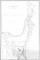
 WELLSTED(1838) p2.490 THE PENINSUOLA OF MOUNT SINAI.jpg 1,539 × 2,343; 1.43 MB
-

-

-

-
 Persia, Arabia, etc - 1852.png 1,310 × 1,024; 2.42 MB
-
 TOBIN(1855) p128 ROUTE ON THE NILE.jpg 2,726 × 3,735; 4.45 MB
-
 1856 Kiepert Map of the Sinai Peninsula, Egypt - Geographicus - Sinai-kiepert-1856.jpg 3,500 × 4,449; 4.12 MB
-
 1865 Spruner Map of Canaan - Mountains of Sinai crop.jpg 1,094 × 632; 177 KB
-
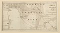
 121 of '(Sinai and Palestine, etc.)' (11073050104).jpg 1,397 × 2,348; 1,001 KB
-

-
 1869 map of the Sinai Peninsula by the Ordnance Survey Office.jpg 23,327 × 30,577; 85.91 MB
-

-
 Biblical tables (1871) (14756367516).jpg 3,120 × 2,026; 1.66 MB
-

-
 Rawson, A.L. Map of Palestine and all Bible lands. 1873.jpg 5,823 × 8,139; 44.47 MB
-
 1873 map of Sinai Peninsula during Exodus.jpg 1,766 × 2,118; 977 KB
-
 Sinai Peninsula. Rawson, A.L. Map of Palestine and all Bible lands. 1873.jpg 1,735 × 2,091; 3.28 MB
-
 Stieler, Adolf. Das Mittellandische Meer Und Nord-Afrika. 1875 BJ.jpg 836 × 1,090; 290 KB
-

-

-

-

-
 20 of 'The Accursed Land; or, First steps on the water-way of Edom' (11169112804).jpg 3,025 × 2,144; 1.12 MB
-
 1885 map Egypt and the Basin of the Nile by Johnston BPL m0612005 detail.png 1,065 × 746; 1.4 MB
-
 105 of 'Buried Cities and Bible Countries' (11212909116).jpg 1,325 × 1,780; 570 KB
-
 66 of 'Buried Cities and Bible Countries' (11211391176).jpg 2,176 × 1,421; 784 KB
-
 MACCOUN(1899) p049 ELIM TO REPHIDIM.jpg 3,590 × 1,968; 3.16 MB
-
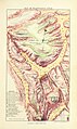
 MACCOUN(1899) p057 MT. SINAI OR JEBEL MUSA.jpg 1,438 × 2,678; 1.89 MB
-

-

-
 D068- N° 436. Egypte et Syrie de Bonaparte. - Liv3-Ch16.png 1,444 × 1,798; 336 KB
-
 Bedouin map.jpg 483 × 746; 250 KB
-
 The Harmsworth atlas and Gazetter 1908 (135850138).jpg 12,561 × 9,578; 123.36 MB
-
 1916 map of Sinai Peninsula, Egypt, the Gulf of Suez and the Gulf of Akaba by the British War Office.jpg 15,719 × 15,179; 34.02 MB
-
 First World War northern Sinai Desert.jpg 816 × 666; 60 KB
-
 Powles pp.32-3RomaniDet.jpeg 1,142 × 908; 341 KB
-
 Ca. 1917 Ottoman Turkish map of the Sinai and Palestine Campaign.jpg 10,084 × 11,482; 13.45 MB
-
 1950s Sinai Peninsula Terrain (30252923214).jpg 3,600 × 4,757; 8.68 MB
-

-

-
 A dictionary of the Bible.. (1887) (14595226549).jpg 2,020 × 3,284; 970 KB
-

-
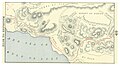
 C+B-Egypt-Fig1-SinaiAndNileDeltaInPluvial.PNG 498 × 597; 179 KB
-

-
 Diario di un viaggio in Arabia Petrea (1865) BHL48741116.jpg 2,268 × 2,872; 752 KB
-
 Die Sieben Säulen der Weisheit, Skizze I.jpg 929 × 1,227; 225 KB
-
 1002-Carte Basse Egypte.jpg 2,816 × 2,112; 1.57 MB
-
 1023-EgyptMap.jpg 2,816 × 2,112; 1.53 MB
-
 Hans Fischer, Das Syrisch - Aegyptische Grenzgebiet (FL10423010 2367090) (cropped3).jpg 4,099 × 2,511; 18.97 MB
-
 Kiepert Sinai map 1840.jpg 10,365 × 13,477; 34.42 MB
-
 Kiepert Sinai St Katherine map 1840 alternate.jpg 3,292 × 4,613; 5.33 MB
-
 Kiepert Sinai St Katherine map 1840.jpg 1,722 × 2,596; 1.22 MB
-
 Map Of Lower Egypt, Sinai And Arabia Petraea.jpg 3,842 × 3,232; 3.58 MB
-
 Meyers b14 s0989 b1.png 388 × 408; 100 KB
-
 Nakhl 1941 closer.jpg 1,164 × 656; 1.2 MB
-
 Karte der Sinai-Halbinsel (NYPL b14291191-37508).jpg 5,016 × 6,299; 6.38 MB
-
 Karte der Sinai-Halbinsel (NYPL b14291191-37508).tiff 5,016 × 6,299; 90.42 MB
-
 Routen in der Sinai-Halbinsel (NYPL b14291191-37509).jpg 4,125 × 4,693; 3.78 MB
-
 Routen in der Sinai-Halbinsel (NYPL b14291191-37509).tiff 5,016 × 6,299; 90.42 MB
-
 Palmer map of Northern Sinai and the Negev.jpg 2,523 × 2,450; 948 KB
-
 Sharm el Sheikh and the Strait of Tiran in the Kiepert Sinai map 1840 (cropped).jpg 2,639 × 1,787; 1.33 MB
-

-
 Sinai Peninsula.jpg 1,387 × 1,400; 520 KB
-
 Sinai. LOC 2012592017.jpg 5,193 × 7,109; 3.44 MB
-
 Sinai. LOC 2012592017.tif 5,193 × 7,109; 105.62 MB
-
 Stieler, Adolf. Das Mittellandische Meer Und Nord-Afrika. 1875 BB.jpg 920 × 1,466; 389 KB
-
 The Times history of the war (1914) (14764640005).jpg 2,122 × 1,356; 443 KB
-
 UBBasel Map Ägypten 1670-1690 Kartenslg Mappe 252-57.tif 11,112 × 8,515, 2 pages; 270.73 MB

.jpg)
_-_btv1b5963525s_(1_of_2).jpg)
_-_btv1b59001126_(1_of_2).jpg)
.jpg)

.jpg)


_(14801210593).jpg)
_p2.971_THE_READ_SEA.jpg)
_p2.490_THE_PENINSUOLA_OF_MOUNT_SINAI.jpg)
.jpg)
.jpg)
%27_(11030535996).jpg)

_p128_ROUTE_ON_THE_NILE.jpg)


%27_(11073050104).jpg)
.jpg)

.jpg)
_(14756367516).jpg)
.jpg)


.jpg)
.jpg)
.jpg)
%27_(11166093863).jpg)
.jpg)

.jpg)
.jpg)
_p049_ELIM_TO_REPHIDIM.jpg)
_p057_MT._SINAI_OR_JEBEL_MUSA.jpg)
.jpg)
%27_(11250727076).jpg)


.jpg)


.jpg)
.jpg)
-_for_popular_and_professional_use,_comprising_full_information_on_Biblical,_theological,_and_ecclesiastical_subjects_(1875)_(14793670453).jpg)
_(14595226549).jpg)
_(14595847020).jpg)


_BHL48741116.jpg)


_(cropped3).jpg)


.jpg)
.jpg)

.jpg)


_(14764640005).jpg)