Category:Narragansett Bay
Jump to navigation
Jump to search
bay comprising 28 miles of coastline in the state of Rhode Island, USA  Most přes Narragansettský záliv | |||||
| Upload media | |||||
| Instance of | |||||
|---|---|---|---|---|---|
| Location |
| ||||
| Located in or next to body of water |
| ||||
| Has part(s) | |||||
| Inflows | |||||
 | |||||
English: Narragansett Bay — on the north side of Rhode Island Sound, in Rhode Island.
- New England's largest estuary.
Subcategories
This category has the following 20 subcategories, out of 20 total.
B
C
- Claiborne Pell Newport Bridge (70 F)
- Conimicut Light (6 F)
F
H
- Hog Island Shoal Light (5 F)
J
- Jamestown Verrazzano Bridge (9 F)
M
- Maps of Narragansett Bay (26 F)
N
P
- Plum Beach Light (14 F)
R
S
W
- Warwick Light (4 F)
Media in category "Narragansett Bay"
The following 56 files are in this category, out of 56 total.
-
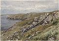
 20180525 - 11 - Newport, RI (Ocean Drive).jpg 2,013 × 1,510; 586 KB
-
 20180525 - 17 - Newport, RI (Ocean Drive) - "Some People's Backyards".jpg 1,965 × 1,225; 467 KB
-
 20180525 - 21 - Newport, RI (Ocean Drive) - "Vanderbilt Vista".jpg 2,025 × 1,519; 638 KB
-
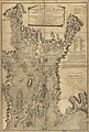
 A chart of the harbour of Rhode Island and Narraganset Bay (3045761151).jpg 1,381 × 2,000; 2.44 MB
-
-
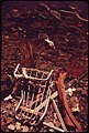
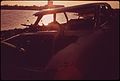 ABANDONED AUTO AT FIELDS POINT ON NARRAGANSETT BAY - NARA - 547484.jpg 3,000 × 2,026; 617 KB
-
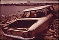 ABANDONED CAR AT FIELDS POINT ON NARRAGANSETT BAY - NARA - 547481.jpg 3,000 × 2,016; 985 KB
-

-

-

-
 'Sabin Point, Narragansett Bay' by Edward Mitchell Bannister, 1885.jpg 1,482 × 840; 343 KB
-
 Barges docked on Narragansett Bay.JPG 4,288 × 2,848; 4.98 MB
-
 BEACH AT MIDDLETOWN - NARA - 547676.jpg 3,000 × 2,017; 842 KB
-
 Black Point.JPG 2,048 × 1,536; 895 KB
-
 BristolRI ColtStatePark NarragansettBayView.jpg 1,024 × 680; 196 KB
-
-
 Cole River Ocean Grove.JPG 1,600 × 1,200; 456 KB
-
 ConanicutIsland.jpg 2,048 × 1,536; 1.12 MB
-
 DUMPING ALONG THE SHORE OF NARRAGANSETT BAY AT FIELDS POINT - NARA - 547485.jpg 2,037 × 3,000; 980 KB
-
 DUMPING ON NARRAGANSETT BAY SHORE - NARA - 547606.jpg 2,032 × 3,000; 1.11 MB
-
 East Bay Bike Path at Sunset.jpg 1,280 × 851; 81 KB
-
 FMIB 39029 Oyster boat dredging up mussels in Narragansett Bay.jpeg 789 × 462; 65 KB
-

-
 Martin Johnson Heade -Thunder Storm on Narragansett Bay ATC.jpg 5,150 × 3,005; 1.54 MB
-
 Improvement Little Narragansett Bay, Rhode Island and Connecticut - NARA - 128215705.jpg 8,112 × 5,714; 1.98 MB
-
 Izzy Paskowitz of Surfer's Healing with Surfer Dustin Sweeney.jpg 2,880 × 2,160; 643 KB
-
 Mussel bed.jpg 750 × 1,000; 121 KB
-
 Musselbed shoal old light.PNG 462 × 390; 140 KB
-

-
 Narragansett Bay Rhode Island June 2021.jpg 4,288 × 2,848; 1.76 MB
-
 NARRAGANSETT BAY SHORE AT FIELDS POINT - NARA - 547472.jpg 3,000 × 2,029; 998 KB
-
 Narragansett Bay surf on the rocks.jpg 3,648 × 2,736; 2.38 MB
-

-
 Narragansett Bay.jpg 650 × 488; 226 KB
-
 Narragansett Towers Casino ruins and lifeguard station.jpg 396 × 221; 23 KB
-

-
 Newport Cliff Walk Sheep Point Cove Narragansett Bay view.jpg 4,320 × 3,240; 3 MB
-
 OIL STAINED BEACH-RESULT OF A SPILL BY A TANKER IN NARRAGANSETT BAY - NARA - 547545.jpg 2,031 × 3,000; 1.14 MB
-
 On the Cliffs beside Fort Wetherill.jpg 4,032 × 3,024; 3.19 MB
-
 Päivi Murphy (2010).jpg 210 × 280; 18 KB
-
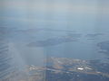
 R000ag00 - Flickr - NOAA Photo Library.jpg 1,772 × 1,088; 1.28 MB
-
 R000ag01 - Flickr - NOAA Photo Library.jpg 1,800 × 1,157; 1.26 MB
-
 R000ag03 - Flickr - NOAA Photo Library.jpg 1,800 × 1,169; 1.29 MB
-
 R0021111 - Flickr - NOAA Photo Library.jpg 1,768 × 1,188; 2.49 MB
-
 Rock jetty in North Kingston, RI.JPG 4,288 × 2,848; 5.39 MB
-

-
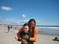
 Surfers Healing Narragansett, Rhode Island.jpg 2,880 × 2,160; 749 KB
-

-
 The magazine of American history with notes and queries (1877) (14598168479).jpg 3,328 × 1,976; 1.55 MB
-
 The past and the present (1879) (14778809044).jpg 2,424 × 3,544; 1.81 MB
-
 The Southern Gateway of New England.jpg 2,267 × 3,078; 5.6 MB
-
 Tomas Murphy (2010).jpg 185 × 225; 13 KB
-
 USS Kasaan Bay (CVE-69) in Narragansett Bay 1944.jpg 899 × 667; 332 KB
-
 USS Purdy (DD-734) underway in Narragansett Bay in 1971.jpg 899 × 675; 353 KB
-
 USS Sidonia (AKA-42) underway in Narragansett Bay (USA), 27 April 1945.jpg 2,788 × 2,068; 3.52 MB
-

.jpg)
_-_%22Some_People%27s_Backyards%22.jpg)
_-_%22Vanderbilt_Vista%22.jpg)
.jpg)


_(19363450805).jpg)
_(14780183011).jpg)
_(19336559536).jpg)


_(14583404400).jpg)


.jpg)


.jpg)

)_(1922)_(14782427805).jpg)
_(14598168479).jpg)
_(14778809044).jpg)

.jpg)
_in_Narragansett_Bay_1944.jpg)
_underway_in_Narragansett_Bay_in_1971.jpg)
_underway_in_Narragansett_Bay_(USA),_27_April_1945.jpg)

,_in_August_1973.jpg)