Category:Maps of Narragansett Bay
Jump to navigation
Jump to search
Wikimedia category | |||||
| Upload media | |||||
| Instance of | |||||
|---|---|---|---|---|---|
| Category combines topics | |||||
| Narragansett Bay | |||||
bay comprising 28 miles of coastline in the state of Rhode Island, USA  Most přes Narragansettský záliv | |||||
| Instance of | |||||
| Location |
| ||||
| Located in or next to body of water |
| ||||
| Has part(s) | |||||
| Inflows | |||||
 | |||||
Media in category "Maps of Narragansett Bay"
The following 26 files are in this category, out of 26 total.
-

-
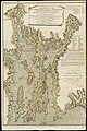
 A Topographical chart of the bay of Narraganset - Blaskowitz - btv1b53089827s.jpg 7,967 × 11,395; 20.51 MB
-
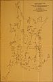
 A Topographical chart of the bay of Narraganset - btv1b53089712r.jpg 2,368 × 3,320; 944 KB
-
-

-

-
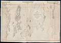 Admiralty Chart No 2892a Rhode Island State Narraganset Bay, Published 1862.jpg 12,505 × 8,835; 13.38 MB
-
 Admiralty Chart No 2892b Rhode Island State Narraganset Bay, Published 1862.jpg 12,505 × 8,734; 13.03 MB
-
-

-

-

-

-

-
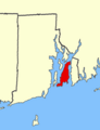 Aquidneck Island map.png 238 × 310; 13 KB
-
 Conanicut.png 238 × 310; 13 KB
-
 FMIB 33454 Narragansett Bay.jpeg 703 × 1,009; 123 KB
-
 FMIB 33477 Providence River and Narragansett Bay.jpeg 695 × 1,017; 128 KB
-
 NarraBayRIMineNetDef01.jpg 816 × 612; 165 KB
-

-
 Prudenceisland.GIF 238 × 310; 12 KB
-
 RIBay.JPG 691 × 1,023; 425 KB
-
 The magazine of American history with notes and queries (1877) (14598169099).jpg 1,952 × 3,640; 508 KB
-
 The magazine of American history with notes and queries (1877) (14804684163).jpg 1,772 × 2,940; 837 KB
-
 The past and the present (1879) (14594532999).jpg 3,200 × 2,616; 1.13 MB
-
 The past and the present (1879) (14594534179).jpg 3,232 × 2,464; 1.05 MB
%27_(11165205255).jpg)


.jpg)


_(19357252442).jpg)
_(19363360455).jpg)
_(14589697947).jpg)
_(19356473412).jpg)
_(19175026050).jpg)
_(19177272039).jpg)


.jpg)


_(14598169099).jpg)
_(14804684163).jpg)
_(14594532999).jpg)
_(14594534179).jpg)