Category:Maps of the history of Belgium
Jump to navigation
Jump to search
Countries of Europe: Albania · Andorra · Armenia‡ · Austria · Azerbaijan‡ · Belarus · Belgium · Bosnia and Herzegovina · Bulgaria · Croatia · Cyprus‡ · Czech Republic · Denmark · Estonia · Finland · France‡ · Georgia‡ · Germany · Greece · Hungary · Iceland · Republic of Ireland · Italy · Kazakhstan‡ · Latvia · Lithuania · Luxembourg · Malta · Moldova · Montenegro · Netherlands‡ · North Macedonia · Norway · Poland · Portugal‡ · Romania · Russia‡ · Serbia · Slovakia · Slovenia · Spain‡ · Sweden · Switzerland · Turkey‡ · Ukraine · United Kingdom
Limited recognition: Abkhazia‡ · Kosovo · South Ossetia‡ · Transnistria · Northern Cyprus‡
‡: partly located in Europe
Limited recognition: Abkhazia‡ · Kosovo · South Ossetia‡ · Transnistria · Northern Cyprus‡
‡: partly located in Europe
Subcategories
This category has the following 27 subcategories, out of 27 total.
A
- Maps of Austrasia (8 F)
B
- Maps of the history of Brabant (29 F)
D
F
H
- Maps of the history of Hainaut (15 F)
L
M
- Maps of the Guelders Wars (8 F)
R
- Maps of the Roman Low Countries (36 F)
S
T
Media in category "Maps of the history of Belgium"
The following 67 files are in this category, out of 67 total.
-
 LageLanden.PNG 585 × 431; 52 KB
-
 Nederlanden 1523.PNG 465 × 600; 82 KB
-
 16 of '(Histoire de la Belgique.)' (11111017204).jpg 2,560 × 1,541; 868 KB
-
 Marlborough Gains.jpg 1,104 × 865; 155 KB
-
 422 of 'England under Stuart Rule, etc' (11246288953).jpg 1,267 × 1,916; 534 KB
-
 Netherlands during French administration 1810-1814.png 520 × 764; 889 KB
-
 LocationUKN.png 250 × 115; 6 KB
-
 Talleyrand partition plan.jpg 560 × 500; 42 KB
-
 United Kingdom of the Netherlands.png 800 × 550; 81 KB
-
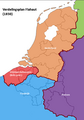
 Verdelingsplan Talleyrand.PNG 961 × 1,351; 205 KB
-
 Verenigd Koninkrijk der Nederlanden (tot 1830).png 628 × 912; 121 KB
-
 Yser ix.jpg 473 × 588; 121 KB
-
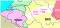 Belgische Strijdkrachten Duitsland.png 330 × 153; 5 KB
-
 279 of 'Bijdragen tot eene geschiedenis der Bataven. (With two maps.)' (11109505674).jpg 5,577 × 1,466; 1.26 MB
-
 281 of 'Bijdragen tot eene geschiedenis der Bataven. (With two maps.)' (11109302925).jpg 2,941 × 4,186; 1.77 MB
-
 334 of '(Histoire de la Belgique.)' (11108891003).jpg 1,541 × 2,574; 717 KB
-
 3limburgen.png 1,035 × 1,540; 62 KB
-
 Antwerpen1477.png 299 × 217; 111 KB
-
 Belgian Medieval Dioceses.png 1,664 × 2,284; 140 KB
-
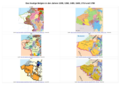 Belgien 1200 1350 1400 1648 u 1714 o Vgl.png 7,016 × 4,962; 6.48 MB
-
 Belgien Luxemburg Limburg Deutscher Bund dt.png 620 × 206; 59 KB
-
 Belgien Luxemburg Limburg Deutscher Bund(2) 01.png 620 × 206; 59 KB
-
 Belgien Luxemburg Limburg Deutscher Bund(2) 02.png 620 × 206; 58 KB
-
 Belgien Luxemburg Limburg Deutscher Bund.png 620 × 206; 50 KB
-
 Belgique 1830.jpg 1,466 × 969; 76 KB
-
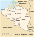
 Belgium c.1850-60.jpg 3,408 × 2,844; 3.64 MB
-
 Belgium-TheNetherlands.PNG 400 × 296; 28 KB
-
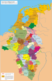
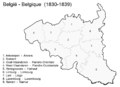 België - Belgique (1830-1839).png 1,329 × 969; 157 KB
-
 Belva.pdf 1,800 × 1,454; 214 KB
-
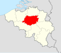 Brabant location map.svg 1,136 × 988; 220 KB
-
 Brunen map2.png 831 × 538; 114 KB
-
 Buste du roi Léopold II, gravure attribuée à Félicien Rops.png 681 × 440; 569 KB
-
 Campagnes du Nord.jpg 934 × 585; 142 KB
-

-
 Chaussée-Brunehault.jpg 723 × 693; 286 KB
-
 Dalhem-comte.jpg 1,677 × 1,537; 478 KB
-
 De LYser a LAisne, Acervo do Museu Paulista da USP (cropped).jpg 4,359 × 6,407; 35.76 MB
-
 Ensemble des Vallonnements Brabançons.png 852 × 486; 466 KB
-
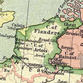
 Flandria Comit. (1).jpg 7,060 × 5,793; 12.71 MB
-
 Flandria Comit. (2).jpg 7,009 × 5,813; 11.85 MB
-
 France map Lambert-93 with regions and departments-occupation Belgium inset.png 1,025 × 462; 149 KB
-
 France map Lambert-93 with regions and departments-occupation Belgium.png 1,996 × 1,894; 975 KB
-
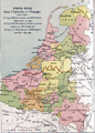
 French departments in the Netherlands and Belgium in 1812.png 2,213 × 2,599; 2.22 MB
-
 French-Belgian frontier zone, 1914.jpg 942 × 701; 151 KB
-
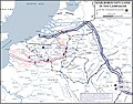
 German advance in Belgium, August 1914.jpg 1,059 × 1,055; 154 KB
-

-

-
 Karte von Deutschland, dem Königr. der Niederlande und der Schweiz.jpg 5,821 × 4,769; 7.38 MB
-
 Kingdom of Belgium c1850-70.png 330 × 355; 32 KB
-
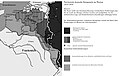 Kriegsziele im Westen.jpg 3,090 × 1,958; 1.23 MB
-
 Limburg-LandenVanOvermaas 1600.gif 2,040 × 2,155; 444 KB
-
 Liège 1477.JPG 310 × 318; 28 KB
-
 Lorena 870-segle XI.png 2,697 × 4,170; 1.99 MB
-
 Luxembourg 1477.jpg 345 × 386; 63 KB
-
 Map Belgica.jpg 385 × 341; 115 KB
-
 Map of Liège diocese until 1559.png 1,664 × 2,284; 82 KB
-
 Map of Luxembourg and southern Belgium 1914.png 1,043 × 1,616; 2.03 MB
-
 Map of the Habsburg Netherlands by Alexis-Marie Gochet.png 532 × 744; 813 KB
-

-
-
 Overmaas-voor-1785 redemptie.png 2,000 × 1,891; 282 KB
-
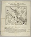
 PlanFlahaut.png 485 × 692; 79 KB
-
 SELECTION OF A POSITION ON THE GETTE.jpg 1,113 × 876; 146 KB
-
 Spruner and Menke - Deutschland's Gaue. II. Mittleres Lothringen (...).jpeg 3,346 × 2,792; 2.54 MB
-
 Super Universas Dioceses NL.png 1,664 × 2,284; 344 KB
-
 Talleyrandwellington.png 528 × 756; 76 KB
-
 VlaanderenArtesie1477.png 327 × 327; 227 KB


%27_(11111017204).jpg)

.jpg)


.png)


%27_(11109302925).jpg)
%27_(11108891003).jpg)


.png)


.jpg)

.jpg)
.jpg)


.jpg)
.jpg)


.jpg)


.jpeg)


%27_(11109505674).jpg)
_01.png)
_02.png)