Category:Maps of the 2011 Tōhoku tsunami
Jump to navigation
Jump to search
Media in category "Maps of the 2011 Tōhoku tsunami"
The following 56 files are in this category, out of 56 total.
-
 2011 Tohoku earthquake observed tsunami heights en.png 700 × 640; 298 KB
-
 2011 Tohoku earthquake observed tsunami heights-2.png 700 × 640; 310 KB
-
 2011 Tohoku earthquake observed tsunami heights.png 700 × 640; 299 KB
-
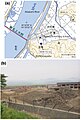
 2011 Tohoku tsunami flooded area Sendai Natori by GSI and Namiwake Shrine.jpg 1,075 × 760; 303 KB
-
 2011 Tohoku tsunami flooded area Sendai Natori by GSI and Yuriage Tamaura.jpg 1,075 × 760; 310 KB
-
 2011 Tohoku tsunami flooded area Sendai Natori by GSI.png 1,075 × 760; 800 KB
-
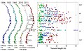
 2011 Tohoku tsunami height by Joint Research Group 2012-03-01.png 1,050 × 1,100; 133 KB
-
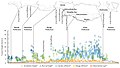
 2011 tsunami wave height.jpg 3,000 × 2,000; 2.35 MB
-
20110311Houshu.ogv 1 min 0 s, 710 × 672; 23.33 MB
-
 2011Sendai-NOAA-Energy plot20110311.png 1,837 × 1,388; 2.48 MB
-
 2011Sendai-NOAA-Energylhvpd9-05.jpg 1,318 × 918; 315 KB
-
 2011Sendai-NOAA-TravelTime-Ttvulhvpd9-06.jpg 900 × 824; 532 KB
-
 Actual inundation areas were much larger than predicted.jpg 1,910 × 1,457; 765 KB
-
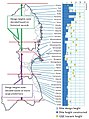
 Actual versus predicted tsunami height MLIT.jpg 2,396 × 1,356; 636 KB
-
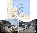
 An example of a tsunami hazard map Miyako City Iwate Prefecture.jpg 1,704 × 907; 198 KB
-
Animated View of March 11, 2011 Tsunami Wave Height Model.ogv 11 s, 400 × 226; 771 KB
-

-
-
 Determining dike height MLIT.jpg 1,284 × 1,728; 522 KB
-
 Energy plot20110311-1000.png 1,000 × 756; 1.26 MB
-
-
 Hazard map produced by the village of Toni in Kamaishi City Iwate Prefecture.jpg 1,219 × 1,683; 428 KB
-
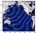
 Honshu2011-globalmaxplot.png 3,275 × 1,460; 13.21 MB
-
-
 Inundation area in Fudai Village - Iwate MLIT.jpg 1,297 × 758; 269 KB
-
-
-

-

-

-
-

-
 Land-use planning and projects in Minamisanriku.jpg 1,717 × 1,204; 382 KB
-
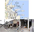
 Minamisoma City - Map of Triple Disaster 2011.png 3,417 × 3,399; 8.9 MB
-
-
-

-
 Miyagi - Minamisanriku - Utatsu -a- Tsunami heights -b and c- Tsunami damage.jpg 2,751 × 2,695; 1.12 MB
-
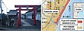 Namiwake Shrine and the inundation area of the 2011 tsunami.jpg 750 × 273; 56 KB
-

-

-

-
 Relocation project in Sendai City.jpg 1,215 × 1,384; 232 KB
-

-

-
-

-

-
Tsunami Animation- Tohoku, Japan 2011 (rotating globe).webm 2 min 43 s, 1,920 × 1,080; 40.07 MB
-

-
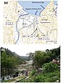
 Tsunami inundation area along the Kitakami and Kyu-Kitakami rivers.jpg 1,290 × 952; 265 KB
-
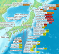
 Tsunami map Tohoku2011.svg 1,483 × 942; 121 KB
-
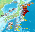
 Tsunami map Tohoku2011jp.svg 1,129 × 942; 560 KB
-
 Uriage Land Cover Change.png 8,185 × 3,692; 21.03 MB
-
 Uriage Land Cover Change.svg 595 × 842; 8.26 MB
-


_in_Onagawa_town_and_the_mechanisms_that_mediated_overturning.gif)


